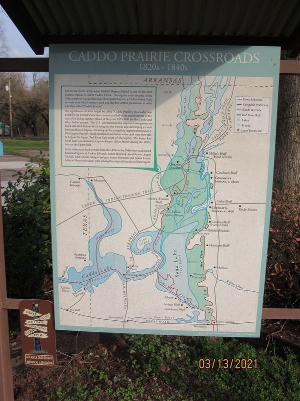
Caddo Prairie Crossroads
1820s - 1840s
The Significance of what might be called "Caddo Prairie Crossroads," was noted by the United States Government and led to the establishment in the area of an Indian Agency House in the years 1825-1831 for the Caddo and other Indian groups. The U.S. Government also improved navigation on Black and Red Bayous by clearing out the bayous and developing a canal between the two bayous. Heading up the navigation improvements was Lt. Washington Seawell. Small steamboats and other water craft were now able to bypass the Upper Red River Raft north of Shreveport. The lower Red River Raft was cleared by Captain Henry Miller Shreve during the 1830s, but not the Upper Raft.
Early settlers and land owners from the 1820s to the 1840s were such noted historical figures as Larkin Edwards, James Shennick, Jacob Irwin, Angus McNeil, John Sewall, Sturgis Sprague, James Herndon and James Erwin. Many of these individuals were among the original founders of Shreveport.
Erected by Red
Topics. This historical marker is listed in these topic lists: Industry & Commerce • Waterways & Vessels. A significant historical year for this entry is 1820.
Location. 32° 49.632′ N, 93° 50.695′ W. Marker is in Gilliam, Louisiana, in Caddo Parish. Marker is on Main Street north of 2nd Street, on the right when traveling north. Located to the right of the Red River Crossroads Historical Association Museum. Touch for map. Marker is at or near this postal address: 12797 Main St, Gilliam LA 71029, United States of America. Touch for directions.
Other nearby markers. At least 8 other markers are within 3 miles of this marker, measured as the crow flies. Town of Gilliam (a few steps from this marker); Gilliam Louisiana (a few steps from this marker); TS&N/T&P Railroad (within shouting distance of this marker); Gilliam United Methodist Church (about 500 feet away, measured in a direct line); Reuben Thom Douglas Home (about 700 feet away); Linda Lay Memorial (about 700 feet away); Justice Chapel Baptist Church (approx. 1.8 miles away); Lynn Plantation (approx. 2.4 miles away). Touch for a list and map of all markers in Gilliam.
Credits. This page was last revised on June 2, 2021. It was originally submitted on June 1, 2021, by Jason Armstrong of Talihina, Oklahoma. This page has been viewed 287 times since then and 48 times this year. Photo 1. submitted on June 1, 2021, by Jason Armstrong of Talihina, Oklahoma. • Mark Hilton was the editor who published this page.
