Nearby History
Explore Charlotte!
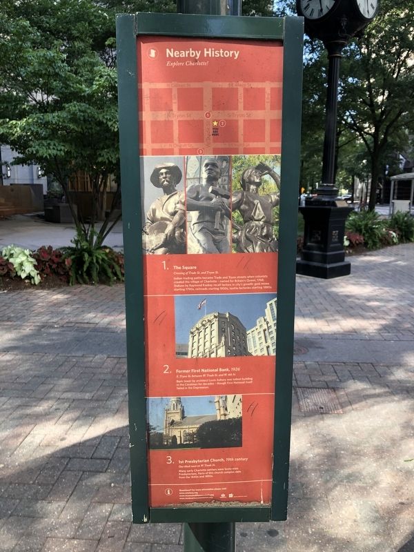
1. The Square
Crossing of Trade St. and Tryon St. Indian trading paths became Trade and Tryon streets when colonists created the village of Charlotte — named for Britain's Queen, 1768. Statues by Raymond Kaskey recall factors in the city's growth: gold mines starting 1790s, railroads starting 1850s, textile factories starting 1880s.
2. Former First National Bank, 1926
S. Tryon St. between W. Trade St. and W. 4th St.
Bank tower by architect Louis Asbury was tallest building in the Carolinas for decades — though First National itself failed in the Depression.
3. 1st Presbyterian Church, 19th century
One block west on W. Trade St.
Many early Charlotte settlers were Scots-Irish Presbyterians. Parts of this church complex date from the 1840s and 1890s.
Erected by City of Charlotte, North Carolina.
Topics. This historical marker is listed in these topic lists: Architecture • Indigenous Peoples and Communities • Industry & Commerce • Railroads & Streetcars • Religion & Religious Structures. A significant historical year for this entry is 1768.
Location. 35° 13.635′ N, 80° 50.573′ W. Marker
this page online

Regionally, this marker is in the Piedmont. It is also in the American South and specifically in the Upper South. Globally, it is in North America, the Western Hemisphere, the Western World, and the Anglosphere. Historically, it finds itself in what was once the territory of the Mississippian Culture, one of the original Thirteen Colonies, one of the Confederate States of America, and the Antebellum South.
Other nearby markers. At least 8 other markers are within walking distance of this marker: The Sculptures at Independence Square (a few steps from this marker); Nathanael Greene (a few steps from this marker); Home of Col. Thomas Polk (a few steps from this marker); Mecklenburg Resolves (within shouting distance of this marker); Independence Square (within shouting distance of this marker);
Credits. This page was last revised on February 3, 2023. It was originally submitted on June 20, 2021, by Devry Becker Jones of Washington, District of Columbia. This page has been viewed 331 times since then and 28 times this year. Photos: 1, 2. submitted on June 20, 2021, by Devry Becker Jones of Washington, District of Columbia.
