Petersburg, Virginia — The American South (Mid-Atlantic)
Battle of Petersburg
25 April 1781
| — | Second Line Of Defense | — |
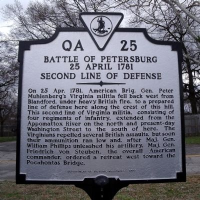
Photographed by Bernard Fisher, March 29, 2009
1. Battle of Petersburg Marker
Erected 2005 by Department of Historic Resources. (Marker Number QA-25.)
Topics and series. This historical marker is listed in this topic list: War, US Revolutionary. In addition, it is included in the Virginia Department of Historic Resources (DHR) series list. A significant historical date for this entry is April 25, 1781.
Location. 37° 13.862′ N, 77° 23.859′ W. Marker is in Petersburg, Virginia. It is on North Madison Street 0.1 miles north of East Washington Street (U.S. 301), on the left when
this page online

Regionally, this marker is in Central Virginia. It is also in the American South and specifically in the Upper South. Globally, it is in North America, the Western Hemisphere, the Western World, and the Anglosphere. Historically, it finds itself in what was once the territory of the Mississippian Culture, one of the original Thirteen Colonies, one of the Confederate States of America, and the Antebellum South.
Other nearby markers. At least 8 other markers are within walking distance of this marker: A different marker also named Battle of Petersburg (a few steps from this marker); East Hill (about 700 feet away, measured in a direct line); Lincoln In Petersburg (approx. 0.2 miles away); Petersburg Volunteers 1812 (approx. 0.2 miles away); a different marker also named Battle of Petersburg (approx. ¼ mile away); Ladies Confederate Hospital (approx. ¼ mile away); William Langhorne Bond (1893-1985) (approx. 0.3 miles
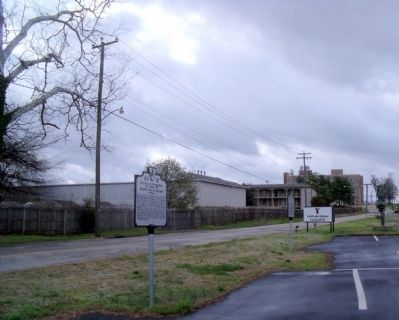
Photographed by Bernard Fisher, March 29, 2009
2. Battle of Petersburg Marker on N Madison St (facing south).
Before the construction of the interstate, this position was substantially higher, and was atop East Hill. The Patriot force was aligned along what is now Madison Street, running from Washington Street in the distance towards the camera and past this view all the way to the river (behind the photographer). Blandford, the direction from which the Patriots came, is generally in the distance beyond the interstate (direction the camera faces).
Related markers. Click here for a list of markers that are related to this marker.
Also see . . . Battle of Blanford, also called the Battle of Petersburg. “The second line, which was to form the main line of defense after the first one fell back, consisted of Ralph Faulkner’s regiment on the left, and John Slaughter’s on the right. The line extended along what is today Madison Street in Petersburg, from a causeway and bridge across the Lieutenant Run, a creek separating Petersburg and Blandford. The line was positioned to maximize the exposure of British troops to gunfire as they approached.” (Submitted on April 23, 2016.)
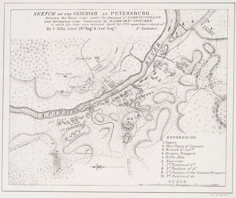
John Hills, from the collections of The New York Public Library, circa 1781
3. Battle of Petersburg Engraving
This 1844 George Endicott engraving of a map sketched after the battle by British Lt. John Hills, an assistant engineer of the 23rd Regiment, shows the position of the marker keyed with the number "7" - the second position of the American forces. The town of Blandford is actually the cluster of buildings further towards the upper right, and the road labeled "to South Key" is today's Old Church Street (and Main Avenue in Blandford Cemetery) - which used to parallel Crater Road. Old Church Street ran right into the center of Old Blandford Town. The area labeled as Blandford is what became the town of Bollingbrook in 1783. The road nearest the river, along which the shaded dark rectangles are buildings, is today's Bank Street, known as the River Road at that time. The road angling up from the bottom of the sketch, labeled "to Hicks Ford", is the Halifax Road (Hicks' Ford is modern Emporia, VA) - where it diverges towards the river, left of the Americans' 2nd position, is modern Sycamore Street. Of note is the bridge shown goes to Pocahontas, which was cut off from Chesterfield County by the re-routing of the Appomattox River at a later date. So, the modern MLK Bridge is not the Patriot escape route - instead the bridge crossed the old river channel in the vicinity of Joseph Jenkins Robert Street, and the Americans regrouped on Pocahontas Island (not modern Colonial Heights as the existing bridge would suggest to the reader).
Credits. This page was last revised on August 23, 2026. It was originally submitted on April 4, 2009, by Bernard Fisher of Richmond, Virginia. This page has been viewed 1,511 times since then and 40 times this year. Photos: 1, 2. submitted on April 4, 2009, by Bernard Fisher of Richmond, Virginia. 3. submitted on August 23, 2026, by Evan Dwyer of Richmond, Virginia.
