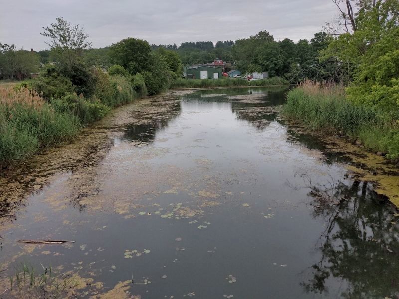
South End in Burlington in Chittenden County, Vermont — The American Northeast (New England)
Pine Street Barge Canal
The combination of raw lumber, water and rail led to Burlington’s rise in the mid-1800s to one of the nation’s most important lumber ports. In the 1860s, entrepreneur Lawrence Barnes saw that more lakefront access was needed to load and unload boats at the increasingly busy industrial port. He owned a bit of swampy land, described as “miasmic frog pond,” near the lakeshore. With the help of forty men, Barnes transformed his swamp into a wood-flanked canal complete with a single-track drawbridge.
The city’s booming lumber industry ended in late 1890s. Lumber companies around the canal were gradually replaced with other businesses, especially coal dealers. A manufactured gas plant opened near the canal in 1895. The plant converted oil and coal into gas for streetlights and heating. Toxic wastes from this process were disposed of in the wetlands around the canal, contaminating the area. In 1983, the canal was designated a Superfund site by the Environmental Protection Agency.
After many years of study and extensive public input, a cleanup plan was devised and the site was restored as a wetland in 2003. The barge canal now supports a variety of wildlife including turtles, ducks, beaver and frogs. The wetland also acts as a natural filter for some of the city’s stormwater runoff, helping to protect Lake Champlain. The only visible reminder of the barge canal’s industrial past ins the circa 1920 steel trunnion bascule (“see-saw”) bridge at the outlet to the lake.
[captions] 1877 Bird’s eye view of Burlington showing the Pine Street Barge Canal at the lower right. Note the milled lumber stacked around the canal and alongside much of Burlington’s waterfront. (Courtesy Special Collections, Baily-Howe Library, University of Vermont.) As the Pine Street Barge Canal fell into disrepute in the early twentieth century, at least five canal boats were abandoned in its waters. This is a composite picture of multiple photographs showing one of these boats. (Courtesy Lake Champlain Maritime Museum.) The canal boats were documented by archeologists from the Lake Champlain Maritime Museum when the canal was drained during the Superfund cleanup. The sunken vessels are considered historically important because they contain information about how these once common watercraft were built. (Courtesy Lake
Champlain Maritime Museum.) In the mid-1880s federal law exempted Canadian timber from tariff. This created a profitable industry, with Canadian boats, known as “pin-flats” bringing forest products to Burlington. (Courtesy Lake Champlain Maritime Museum.) During the late-1800s, much of Burlington’s waterfront was taken up by lumberyards. In fact, parts of Burlington’s waterfront today are actually built on top on thousands of tons of compacted wood chips! (Courtesy Special Collections, Baily-Howe Library, University of Vermont.)
Erected by Lake Champlain Basin Program.
Topics. This historical marker is listed in this topic list: Waterways & Vessels. A significant historical year for this entry is 1870.
Location. 44° 28.148′ N, 73° 13.14′ W. Marker is in Burlington, Vermont, in Chittenden County. It is in South End. Marker can be reached from Island Line (Bike/Pedestrian) Trail, 0.2 miles south of Railway Lane, on the right when traveling south. Marker is south of Roundhouse Park on a bike/pedestrian paved path. Access the park from Railway Lane southward, which is at the foot of Maple Street. Touch for map. Marker is in this post office area: Burlington VT 05401, United States of America. Touch for directions.
Other nearby markers. At least 8 other markers are within walking distance of this marker. Dr. Charles N. Perkins (approx. 0.3 miles away); Ground Beneath Your Feet (approx. 0.3 miles away); Vermont / Steamer "Vermont" (approx. 0.4 miles away); Union Station (approx. 0.4 miles away); Lake Champlain Navy Memorial (approx. half a mile away); The Battle of Plattsburgh Bay (approx. half a mile away); The Lone Sailor (approx. half a mile away); The Battle of Valcour Island (approx. half a mile away). Touch for a list and map of all markers in Burlington.
Credits. This page was last revised on February 16, 2023. It was originally submitted on July 11, 2021, by Anton Schwarzmueller of Wilson, New York. This page has been viewed 122 times since then and 20 times this year. Photos: 1, 2, 3, 4, 5. submitted on July 11, 2021, by Anton Schwarzmueller of Wilson, New York.


