Near Silverton in San Juan County, Colorado — The American Mountains (Southwest)
Howardsville
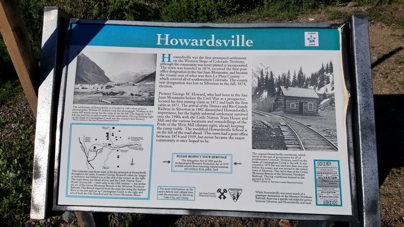
Howardsville was the first attempted settlement on the Western Slope of Colorado Territory, although the community was never platted or incorporated. The town was founded in 1874, received the first post office designation in the San Juan Mountains, and became the county seat of what was then La Plata County which covered all of southwestern Colorado. The county seat designation was lost to Silverton in the fall, 1874, election.
Pioneer George W. Howard, who had been in the San Juan Mountains before the Civil War as a prospector, located his first mining claim in 1872 and built the first cabin in 1873. The arrival of the Denver and Rio Grande Railway in Silverton in 1882 diminished Howardsville's importance, but the highly informal settlement survived into the 1940s with the Little Nation Tram House and Mill and the various locations and remodellings of the Pride of the West Mill (distant right, ahead) keeping the camp viable. The modified Howardsville School is on the left of the road ahead. This town had a post office between 1874 and 1939, but never became the major community it once hoped to be.
Map
This composite map shows some of the key structures in Howardsville throughout the years. Founder George Howard's cabin (no longer in existence) was behind you at the end of the terrace on the right. The main street was ahead of you, and the Little Nation Tram House on your left - built early in the 20th century. The arc of the Green Mountain Branch of the Silverton Northern was within Railroad. This Branch departed from the main line along the Animas River to the left and ran up Cunningham Gulch to the right and served both the Old Hundred and the Green Mountain Mines.
Captions
1. The settlement of Howardsville as it looked in 1883 when pioneer photographer William H. Jackson took this photograph. Nothing in this scene still stands except for the cabin at the far left. The flagpole at the left was used for an early Fourth of July celebration. The log building right on the bank of Cunningham Creek was the county's first brewery.
- Photo courtesy of San Juan County Historical Society
2. The original Howardsville courthouse, which served as the seat of government for all of southwestern Colorado Territory, stood on the banks of Cunningham Creek to the left. It was erected in 1874 but was used less than one year before the county seat was moved to the newer town of Silverton. The rail is that of the Green Mountain Branch of the Silverton Northern Railroad. The log courthouse burned to the ground in 1954.
Photo courtesy of San Juan County Historical Society
3. While Howardsville was never much of a passenger destination on the Silverton Northern Railroad, there was a specific rail ticket for service between Silverton and Howardsville and back.
Erected by San Juan County Historical Society, U.S. Department of the Interior - Bureau of Land Management.
Topics. This historical marker is listed in these topic lists: Industry & Commerce • Settlements & Settlers.
Location. 37° 50.123′ N, 107° 35.718′ W. Marker is near Silverton, Colorado, in San Juan County. Marker is at the intersection of County Highway 2 and County Highway 4, on the right when traveling east on County Highway 2. The marker is located on the west side of the old town of Howardsville. Touch for map. Marker is at or near this postal address: Animas Forks Road, Silverton CO 81433, United States of America. Touch for directions.
Other nearby markers. At least 8 other markers are within 4 miles of this marker, measured as the crow flies. Arrastra Gulch (approx. 1.8 miles away); Wealth of Mining History (approx. 2.3 miles away); Tailings Ponds Reclamation (approx. 2.3 miles away); Mayflower Mill (approx. 2.3 miles away); Mayflower Mill Tailing Ponds (approx. 2.3 miles away); San Juan County Memorial (approx. 3.8 miles away); Silverton Northern Caboose 1005 (approx. 3.9 miles away); S.R.R. Caboose (approx. 3.9 miles away). Touch for a list and map of all markers in Silverton.
Also see . . .
Alpine Loop. Colorado Department of Transportation website entry:
The Alpine Loop is truly a backcountry experience. Make sure someone knows your travel plans and do your homework before you start your trip. Make sure you have plenty of water, food and fuel to make it to your destination. Electronics and wireless devises DO NOT work in most places on the Alpine Loop. It is recommended that you download or print hard copy maps prior to your trip. The Alpine Loop Backcountry Byway is a rugged 4x4 road that winds through the spectacular scenery of the San Juan Mountains, connecting Lake City, Silverton, and Ouray. The Alpine Loop byway traverses passes up to 12,800 feet while showcasing old mines, ghost towns, natural wonders, beautiful wildflowers, and abundant wildlife. Alpine Loop is an avenue for exploring nature and history amidst thrilling views and stunning geography. Tackling the loop in its entirety is easily an all-day experience event. However, the main loop is only part of the experience; miles of designated side routes allow visitors to either take a short tour or extend their trip to multiple days. For more information, please contact the Gunnison Field Office.(Submitted on July 21, 2021, by James Hulse of Medina, Texas.)
Credits. This page was last revised on May 8, 2023. It was originally submitted on July 20, 2021, by James Hulse of Medina, Texas. This page has been viewed 207 times since then and 31 times this year. Photos: 1, 2, 3. submitted on July 21, 2021, by James Hulse of Medina, Texas.


