South Nashville in Davidson County, Tennessee — The American South (East South Central)
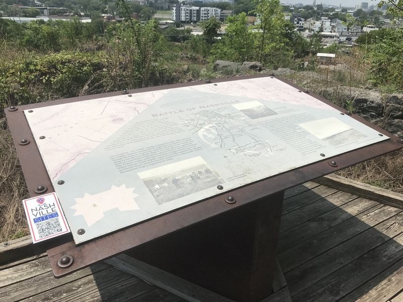
The Battle of Nashville
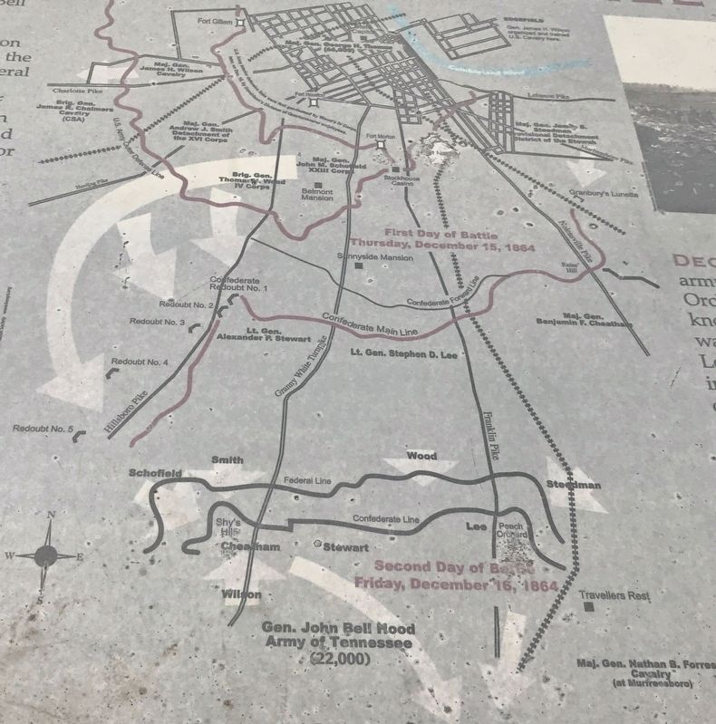
"The sharp points of frozen mud rendered it difficult, and even painful, for Hood's brave bare-footed men to maneuver. Why Thomas did not capture Hood's whole army seemed strange to us." — Private W.J. Worsham, 19th Tennessee, USAOn December 2, 1864, Confederate commander John Bell Hood led his wounded Army of Tennessee to the outskirts of Nashville. Though suffering heavy losses at Franklin on November 30th, he was determined to capture the Union garrison under the command of Major General George H. Thomas. Hood spent almost two weeks fortifying his position south of the city through a series of redoubts along the Hillsboro Pike. He extended his line east in a semicircular arc, ending just west of the Murfreesboro Pike. Amid bitter cold temperatures and freezing rain, the Confederates waited for a Union attack.
December 15, 1864 Finally, on December 15th, after a break in the weather, Thomas assailed Hood's right flank at Granbury's Lunette. Though the Federal troops were repulsed, the main Union assault came along the far left Confederate flank in the early afternoon against the series of Confederate fortifications, called redoubts, along the Hillsboro Pike. Federal cavalry under the command of major General James H. Wilson and two Union infantry corps successfully captured the redoubts and forced Hood's army to retreat to positions two miles south. Artillery fire from Fort Negley supported the attack.
December 16, 1864 On the afternoon of the 16th, the Union army again assailed both Confederate flanks, the right at Peach Orchard Hill above the Franklin Pike and on the left at Compton's Hill, known today as Shy's Hill. A regiment of United States Colored Troops was repeatedly beaten back by Confederate Major General Stephen D. Lee's Corp on the Confederate right. The U.S.C.T. Thirteenth Tennessee infantry suffered 221 casualties out of 576 men. On the Confederate left, Union Brigadier General John McArthur captured Compton's Hill late in the day, turning the Confederate left flank and sending the army, save Lee's position at Peach Orchard Hill, in retreat. By sundown, the Army of Tennessee had abandoned the field. The Confederates suffered 4,400 casualties, the Union 3,000. Nashville was one of the most complete and decisive Union victories of the war. Fort Negley was never directly attacked during the two-day battle.
Captions
(Left) Union troops during the Battle of Nashville.
(Right, top) View of Casino Blockhouse from below Fort Negley. Casino Blockhouse was located on the hill straight ahead, where the City Water Reservoir was later built.
(Right, bottom) Fog draped Nashville both days of
the battle.
Erected 2004 by Metropolitan Government of Nashville and Davidson County Parks & Recreation.
Topics. This historical marker is listed in these topic lists: African Americans • War, US Civil. A significant historical date for this entry is December 15, 1864.
Location. 36° 8.693′ N, 86° 46.498′ W. Marker is in Nashville, Tennessee, in Davidson County. It is in South Nashville. Marker can be reached from Fort Negley Boulevard north of Chestnut Street, on the right when traveling north. Marker is located within the ruins of Fort Negley. Touch for map. Marker is at or near this postal address: 1100 Fort Negley Boulevard, Nashville TN 37203, United States of America. Touch for directions.
Other nearby markers. At least 8 other markers are within walking distance of this marker. Peach Orchard Hill (here, next to this marker); Fort Design (within shouting distance of this marker); Fortress Nashville / Forts (within shouting distance of this marker); Sally Port (within shouting distance of this marker); Union Major General Don Carlos Buell (about 300 feet away, measured in a direct line); Decline and Restoration of Fort Negley (about 300 feet away); Nashville Surrendered (about 400 feet away); A Birthplace of Freedom (about 400 feet away). Touch for a list and map of all markers in Nashville.
Also see . . . The Battle of Nashville. Overview of the battle by Ross Massey, the Battle of Nashville Trust's historian. (Submitted on August 1, 2021, by Duane and Tracy Marsteller of Murfreesboro, Tennessee.)
Credits. This page was last revised on February 7, 2023. It was originally submitted on August 1, 2021, by Duane and Tracy Marsteller of Murfreesboro, Tennessee. This page has been viewed 179 times since then and 14 times this year. Photos: 1, 2, 3. submitted on August 1, 2021, by Duane and Tracy Marsteller of Murfreesboro, Tennessee.


