Williamson in Mingo County, West Virginia — The American South (Appalachia)
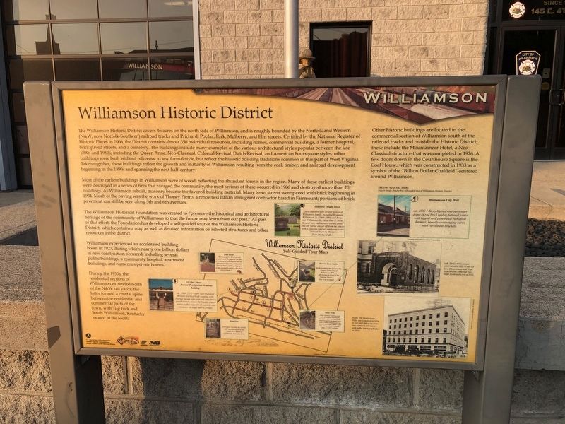
Williamson Historic District
— National Coal Heritage Trail —
The Williamson Historic District covers 46 acres on the north side of Williamson, and is roughly bounded by the Norfolk and Western (N&W, now Norfolk-Southern) railroad tracks and Prichard, Poplar, Park, Mulberry, and Elm streets. Certified by the National Register of Historic Places in 2006, the District contains almost 350 individual resources, including homes, commercial buildings, a former hospital, brick paved streets, and a cemetery. The buildings include many examples of the various architectural styles popular between the late 1890s and 1950s, including the Queen Anne, Neo-Classical, Colonial Revival, Dutch Revival, and American Foursquare styles; other buildings were built without reference to any formal style, but reflect the historic building traditions common in this part of West Virginia. Taken together, these buildings reflect the growth and maturity of Williamson resulting from the coal, timber, and railroad development beginning in the 1890s and spanning the next half-century.
Most of the earliest buildings in Williamson were of wood, reflecting the abundant forests in the region. Many of these earliest buildings were destroyed in a series of fires that ravaged the community; the most serious of these occurred in 1906 and destroyed more than 20 buildings. As Williamson rebuilt, masonry became the favored building material. Many town streets were paved with brick beginning in 1904. Much of the paving was the work of Thoney Pietro, a renowned Italian immigrant contractor based in Fairmount; portions of brick pavement can still be seen along 5th and 6th avenues.
The Williamson Historical Foundation was created to "preserve the historical and architectural heritage of the community of Williamson so that the future may learn from our past." As part of that effort, the Foundation has developed a self-guided tour of the Williamson Historic District, which contains a map as well as detailed information on selected structures and other resources in the district.
Williamson experienced an accelerated building boom in 1927, during which nearly one billion dollars in new construction occurred, including several public buildings, a community hospital, apartment buildings, and numerous private homes.
During the 1930s, the residential sections of Williamson expanded north of the N&W rail yards; the latter formed a central spine between the residential and commercial parts of the town, with Tug Fork and South Williamson, Kentucky, located to the south.
Other historic buildings are located in the commercial section of Williamson south of the railroad tracks and outside the Historic District; these railroad tracks and outside the Historic District; these
[Captions, clockwise from top right:]
Williamson City Hall
ca. 1900 1-Story hipped roof passenger depot of red brick laid in buttered joints with hipped roof penetrated by hipped dormers; broadly overhanging eaves with curvilinear brackets.
Left: The Coal House was constructed in 1933 of over 65 tons of bituminous coal. This structure has withstood four major floods and a fire in 2010.
Right: The Mountaineer Hotel was completed in 1926. It cost $600,000 at the time and contained 116 rooms with baths, (photograph taken in 1933).
Stone Walls
Many beautiful retaining stone walls of masonry construction, executed both in brick and stone, found throughout the district were built by Italian stonemasons, Joe Raimella and Robert Zando. Look for them as you drive around. Date: c. 1892 and after.
Metal Gate
Entry gate bearing the initials LBC manufactured by the Stuart Iron Works of Cincinnati. (See map #14.)
138 Oak STreet, Former Presbyterian Academy Building
ca. 1904 2 1/2-story Neo Classical Revival-inspired brick building with five bay façade and centered entry brick porch extends across the façade; fenestration is flat-topped with six-over-six windows set singly and in groups.
Brick Streets
1904 and after. Brick-paved streets found throughout the district, many of which were laid by Morgantown paving contractor Thoney Pietro in the early years of the twentieth century (See brick icons on map.)
Cemetery - Maple Street
Early cemetery with several graves of Williamson family, including Benjamin Williamson Jr. (1808-1880) and Benjamin Williamson Sr., (died June 6, 1854). Several very rudimentary carved stones and one burial site set off from the others with a concrete barrier, tombstone reads "Servant Mammy Maria", Date-1854 and after.
Historic Stone Marker
Stone marking the Geographic Center of the City of Williamson, WV on 5th Avenue in front of the Linkous House. (See icon on map.)
Erected by Eastern Federal Lands Highway Division, Federal Highway Administration, U.S. Department of Transportation; National Coal Heritage Area; Norfolk & Southern.
Topics. This historical marker is listed in these topic lists: Architecture • Cemeteries & Burial Sites • Industry & Commerce • Railroads & Streetcars. A significant historical date for this entry is June 6, 2006.
Location. 37° 40.383′ N, 82° 16.568′ W. Marker is in Williamson, West Virginia, in Mingo County. Marker is on 4th Avenue (U.S. 52) just south of Logan Street, on the right when traveling north. Touch for map. Marker is at or near this postal address: 208 Logan St, Williamson WV 25661, United States of America. Touch for directions.
Other nearby markers. At least 8 other markers are within 5 miles of this marker, measured as the crow flies. Williamson and the Railroad (within shouting distance of this marker); Williamson (within shouting distance of this marker); Veterans Memorial (about 600 feet away, measured in a direct line); Williamson, Mingo County (about 700 feet away); Chief Logan (about 700 feet away); West Virginia (Mingo County) / Kentucky (approx. 0.2 miles away); The Ohio Extension (approx. 3.3 miles away); Baby’s Grave Site (approx. 4.2 miles away in Kentucky). Touch for a list and map of all markers in Williamson.
Credits. This page was last revised on August 3, 2021. It was originally submitted on August 2, 2021, by Devry Becker Jones of Washington, District of Columbia. This page has been viewed 328 times since then and 38 times this year. Photos: 1, 2. submitted on August 2, 2021, by Devry Becker Jones of Washington, District of Columbia.

