Port Townsend in Jefferson County, Washington — The American West (Northwest)
Port Townsend's Waterfront
Then and Now
Photographed by William Fischer, Jr., August 2, 2021
1. Port Townsend's Waterfront Marker
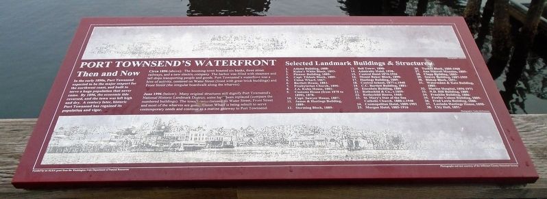
In the early 1890s, Port Townsend expected to be the major seaport for the northwest coast, and built to serve a huge population that never came. By 1896, the economic tide reserved, and the town was left high and dry. A century later, historic Port Townsend has regained its population and vigor.
Circa 1896 (above): The booming town boasted six banks, three street railways, and a new electric company. The harbor was filled with steamers and tall ships transporting people and goods. Port Townsend's waterfront was a hive of activity, centered on Water Street (lined with great brick buildings) and Front Street (the irregular boardwalk along the wharves).
June 1996 (below): Many original structures still dignify Port Townsend's National Historic Landmark District; some have been replaced (compare the numbered buildings). The town is now focused on Water Street; Front Street and most of the wharves are gone. Union Wharf is being rebuilt to serve contemporary needs and continue as a maritime gateway to Port Townsend.
Selected Landmark Buildings & Structures
[not transcribed]
Erected by Washington State Department of
this page online
Topics. This historical marker is listed in this topic list: Settlements & Settlers. A significant historical month for this entry is June 1996.
Location. 48° 6.803′ N, 122° 45.345′ W. Marker is in Port Townsend, Washington, in Jefferson County. It can be reached from Taylor Street. Marker is on the Union Wharf, near the pavilion, at the south end of Taylor Street. Touch for map. Marker is in this post office area: Port Townsend WA 98368, United States of America. Touch for directions.

Regionally, this marker is in the Olympic Peninsula. It is also on the American Pacific Coast, in the Pacific Northwest, and in the Lewis & Clark Corridor. Globally, it is in North America, on the Pacific Rim, in the Western Hemisphere, in the Western World, and in the Anglosphere.
Other nearby markers. At least 8 other markers are within walking distance of this marker: Bounty of the Bay (a few steps from this marker); Union Wharf / Indian Island (a few steps from this marker); Union Wharf: A Century of Continuous Service (within shouting distance of this marker); Welcome to Port Townsend: Washington's Victorian Seaport (within

Photographed by William Fischer, Jr., August 2, 2021
2. Port Townsend's Waterfront and Marker
Credits. This page was last revised on May 11, 2025. It was originally submitted on August 16, 2021, by William Fischer, Jr. of Reynoldsburg, Ohio. This page has been viewed 275 times since then and 29 times this year. Photos: 1, 2. submitted on August 16, 2021, by William Fischer, Jr. of Reynoldsburg, Ohio.
