
Marker Logo
THE HISTORICAL
MARKER DATABASE
“Bite-Size Bits of Local, National, and Global History”
Divide near Silver Bow in Silver Bow County, Montana — The American West (Mountains)
 

Keep Watching The Skies!
 
 
Keep Watching The Skies! Marker image. Click for full size.
Photographed by Barry Swackhamer, July 11, 2021
1. Keep Watching The Skies! Marker
Inscription.
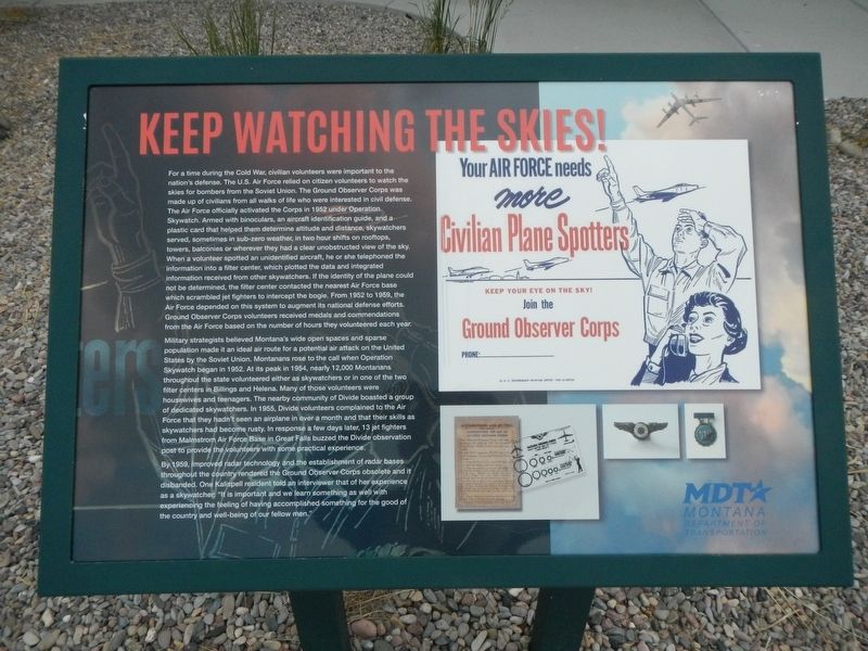
For a time during the Cold War, civilian volunteers were important to the nation's defense. The U.S. Air Force relied on citizen volunteers to watch the skies for bombers from the Soviet Union. The Ground Observer Corps was made up of civilians from all walks of life who were interested in civil defense. The Air Force officially activated the Corps in 1952 under Operation Skywatch. Armed with binoculars, the aircraft identification guide, and a plastic card that helped to determine altitude and distance, skywatchers served, sometimes in sub-zero weather, in two hour shifts on rooftops, towers, balconies or wherever they had a clear unobstructed view of the sky. When a volunteer spotted an unidentified aircraft, he or she telephoned the information into a filter center, which plotted the data and integrated information received from other skywatchers. It the identity of the plane could not be determined, the filter center contacted the nearest Air Force base which scrambled jet fighters to intercept the bogie. From 1952 to 1959, the Air Force depended on this system to augment its national defense efforts. Ground Observer
Paid Advertisement
Click or scan to see
this page online
Corps volunteers received medals and commendations for the Air Force based on the number of hours they volunteered each year.
Military strategists believed Montana's wide open spaces and space population made an ideal air route for a potential air attack on the United States by the Soviet Union. Montanans rose to the call when Operation Skywatch began in 1952. At its peak in 1954, nearly 12,000 Montanans throughout the state volunteered either as skywatchers or in one of the two filter centers in Billings and Helena. Many of those were housewives and teenagers. The nearby community of Divide boasted a group of dedicated skywatchers. In 1955, Divide volunteers complained to the Air Force that they hadn't seen an airplane in over a month and that their skills as skywatchers had become rusty. In response a few days later, 13 jet fighters from Malmstrom Air Force Base in Great Falls buzzed the Divide observation post to provide the volunteers with some practical experience.
By 1959, improved radar technology and the establishment of radar bases throughout the country rendered the Ground Observer Corps obsolete and it was disbanded.
Keep Watching The Skies! Marker image. Click for full size.
Photographed by Barry Swackhamer, July 11, 2021
2. Keep Watching The Skies! Marker
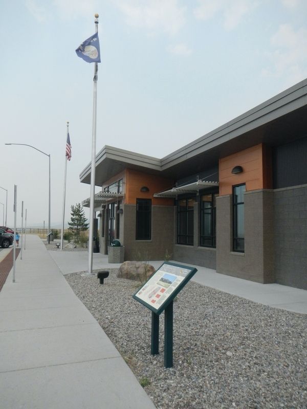
The marker is in the distance near the American Flag pole.
One Kalispell resident told an interviewer that of her experience as a skywatcher: "It is important and we learned something as well with experiencing the feeling of having accomplished something for the good of the country and well-being of our fellow men."
 
Erected by Montana Department of Transportation.
 
Topics. This historical marker is listed in these topic lists: Air & SpaceWar, Cold.
 
Location. 45° 50.097′ N, 112° 41.031′ W. Marker is near Silver Bow, Montana, in Silver Bow County. It is in Divide. It is on Interstate 15 at milepost 111 near Divide Creek Road. The marker is located in the North Bound Feely Rest Stop. Touch for map. Touch for directions.

Regionally, this marker is in Montana’s Colorado River Valley, specifically in Flagstaff & High Country, on the Mogollon Rim, in the Prescott Area, in Verde Valley, in the White Mountains, in The Valley (the San Fernando Valley), in the Inland Empire, in Silicon Valley, in the Coachella Valley, in the Colorado Desert, in the Gold Country, in the High Desert, in the Mojave Desert, in the San Bernardino

Ground Observer Corps pin image. Click for full size.
Photographed by Wikipedia
3. Ground Observer Corps pin
Mountains, in the San Luis Valley, in the Berkshire Foothills, in the Connecticut River Valley, on the Connecticut Shoreline, on the Gold Coast, in Greater Bridgeport, in Greater Hartford, in Greater New Haven, in Greater New London, in the Knowledge Corridor, in the Litchfield Hills, in Mystic and the Eastern Shore, in the Quiet Corner, in the Thames River Valley, on Delaware’s Beaches, in Southern New Castle County, in the Everglades, on the Florida Keys, on Hilo and East Hawaii, on the Kona Coast, on North Shore Oahu, on Pearl Harbor and Historic West Oahu, in Upcountry Maui, in Lahaina and West Maui, on Windward Oahu, in the Quad Cities, on the Indiana Dunes and Lake Michigan Shore, in the Calumet Region, in the Spirit Lake Nation, in the Mandan, Hidatsa, and Arikara Nation, in the Turtle Mountain Band of Chippewa, on the Oglala Lakota Pine Ridge Reservation, in the Rosebud Sioux Tribe, in the Standing Rock Sioux Tribe, on the Cheyenne River Reservation, in the Crow Creek Sioux Tribe, on the Coeur d'Alene Reservation, in the Lower Brule Sioux Tribe, on the Kootenai Reservation, in the Sisseton-Wahpeton Oyate, on the Wind River Indian Reservation, on the Shoshone–Paiute Duck Valley Reservation, on the Southern Ute Indian Reservation, in the Yankton Sioux Tribe, in the Navajo Nation, on the Shoshone-Bannock Fort Hall Reservation, on the Ute Mountain Ute Indian Reservation, on Nez Perce Tribal Land, in the Blackfeet Nation, in the Crow Nation, in the Flathead Nation, in the Fort Belknap Indian Reservation, on the Fort Peck Indian Reservation, in the Northern Cheyenne Nation, on the Rocky Boy’s Reservation, in the Tohono O’odham Nation, in the White Mountain Apache Nation, in the Yavapai-Apache Nation, in the Amana Colonies, on Mount Desert Island, in the Kennebec Valley, in the Maine Highlands, in Midcoast Maine, on Penobscot Bay, on Southern Maine Coast, in the Western Maine Lakes and Mountains Region, in Greater Bangor, in Greater Portland, in the Baltimore Metro Region, in Central Maryland, in Historic Boston, on Cape Ann, on the North Shore, in the South Coast, on the South Shore, in Greater Boston, on the Straits of Mackinac, on the Boundary Waters Canoe Area Wilderness, in Greater Duluth — The Twin Ports, in Southwest Montana, in Gold West Country, in Mining Country, in Greater Billings, in the Lakes Region, in the Merrimack Valley, in North Jersey, in Central Jersey, on the Jersey Shore, in the Pine Barrens, in Piedmont Triad, on the Cape Fear Coast, on the Crystal Coast, in Greater Asheville, in Greater Charlotte, on the Outer Banks, in the Research Triangle, on the Oregon Coast, in the Blackstone Valley, in Greater Providence, on Narragansett Bay, in Newport and Aquidneck Island, in Historic Charleston, on the Grand Strand, on the Sea Islands, on Waccamaw Neck, in the Ashepoo, Combahee and Edisto Basin, in the Foothills, in Congaree Country, in Greater Burlington, in the Mid-Ohio Valley and in the Jackson Hole Area. It is also in the American Mountain West, in the Ohio River Valley, on the Colorado Plateau, in the Black Hills, in the Lewis & Clark Corridor, in the Chesapeake Bay Region, and on the Eastern Seaboard. Globally, it is in the North Atlantic Region, North America, the Great North Woods, the Rocky Mountains, the Western Hemisphere, the Western World, and the Anglosphere. Historically, it finds itself in what was once Fairfield County, Hartford County, Litchfield County, Middlesex County, New Haven County, New London County, Tolland County, Windham County, the Viceroyalty of New France, Acadia, Rupert’s Land, and the Louisiana Purchase.

Other nearby markers. At least 8 other markers are within 14 miles of this marker,
Paid Advertisement
measured as the crow flies: Plutons and the Humbug Spires (a few steps from this marker); Pay Gold (approx. 11.9 miles away); Robert Emmet Literary Association (approx. 12.4 miles away); Spanish-American War Veterans Memorial (approx. 12½ miles away); Mass Rock / Carraig an Aifrinn (approx. 12½ miles away); Milwaukee Depot (approx. 13.4 miles away); Montana Tech Campus Library/Museum (approx. 13.6 miles away); Chasing the Minerals (approx. 13.6 miles away).
 
Also see . . .  Operation Skywatch. The Project Blue Book Research Center website entry:
Following are a few very good news articles from the time that reflect the public’s perception of Operation Skywatch: (Submitted on September 1, 2021, by Barry Swackhamer of Brentwood, California.) 
 
 
Credits. This page was last revised on February 16, 2023. It was originally submitted on September 1, 2021, by Barry Swackhamer of Brentwood, California. This page has been viewed 762 times since then and 51 times this year. Photos:   1, 2, 3. submitted on September 1, 2021, by Barry Swackhamer of Brentwood, California.

m=180831

CeraNet Cloud Computing sponsors the Historical Marker Database.
This website earns income from purchases you make after using our links to Amazon.com. We appreciate your support.
Paid Advertisement
Sep. 8, 2026