Hanover in York County, Pennsylvania — The American Northeast (Mid-Atlantic)
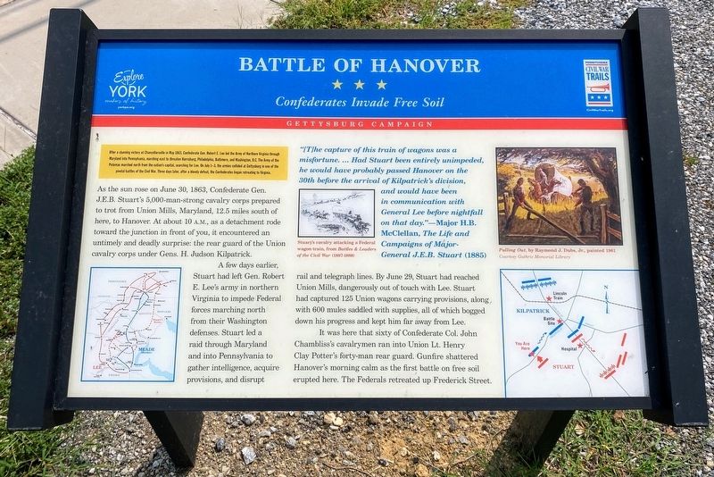
Battle of Hanover
Confederates Invade Free Soil
— Gettysburg Campaign —
After a stunning victory at Chancellorsville in May 1863, Confederate Gen. Robert E. Lee led the Army of Northern Virginia through Maryland into Pennsylvania, marching east to threaten Harrisburg, Philadelphia, Baltimore, and Washington D.C. The Army of the Potomac marched north from the nation’s capital, searching for Lee. On July 1-3, the armies collided at Gettysburg in one of the pivotal battles of the Civil War. Three days later, after a bloody defeat, the Confederates began retreating to Virginia.
As the sun rose on June 30, 1863, Confederate Gen. J.E.B. Stuart’s 5,00-man-strong cavalry corps prepared to trot from Union Mills, Maryland, 12.5 miles south of here, to Hanover. At about 10 A.M., as a detachment rode towards the junction in front of you, it encountered an untimely and deadly surprise: the rear guard of the Union cavalry corps under Gens. H. Judson Kilpatrick.
A few days earlier, Stuart had left Gen. Robert E. Lee’s army in northern Virginia to impede Federal forces marching north from their Washington defenses. Stuart led a raid through Maryland and into Pennsylvania to gather intelligence, acquire provisions, and disrupt rail and telegraph lines. By June 29, Stuart had reached Union Mills, dangerously out of touch with Lee. Stuart had captured 125 Union wagons carrying provisions, along with 600 mules saddled with supplies, all of which bogged down his progress and kept him far away from Lee.
It was here that sixty of Confederate Col. John Chambliss’s cavalrymen ran into Union Lt. Henry Clay Potter’s forty-man rear guard. Gunfire shattered Hanover’s morning calm as the first battle on free soil erupted here. The Federals retreated up Frederick Street.
“[T]he capture of this train of wagons was a misfortune. …Had Stuart been entirely unimpeded, he would probably have passed Hanover on the 30th before the arrival of Kilpatrick’s division, and would have been in communication with General Lee before nightfall on that day.”—Major H.B. McClellan, The Life and Campaigns of Major General J.E.B. Stuart 1885
(image captions)
Stuart’s cavalry attacking a Federal wagon train, from Battles and Leaders of the Civil War (1887-1888)
Pulling Out, by Raymond J. Dubs, Jr., painted 1961
Courtesy Guthrie Memorial Library
Erected by Pennsylvania Civil War Trails & York County.
Topics and series. This historical marker is listed in this topic list: War, US Civil. In addition, it is included in the Pennsylvania Civil War Trails series list. A significant historical date for this entry is June 30, 1863.
Location. 39°
47.599′ N, 76° 59.499′ W. Marker is in Hanover, Pennsylvania, in York County. Marker is at the intersection of Frederick Street (Pennsylvania Route 194) and Stuart Avenue, on the left when traveling north on Frederick Street. Touch for map. Marker is in this post office area: Hanover PA 17331, United States of America. Touch for directions.
Other nearby markers. At least 8 other markers are within walking distance of this marker. Stuart's Fruitless Odyssey (here, next to this marker); The Confederates Invade Pennsylvania (a few steps from this marker); Gettysburg Campaign (within shouting distance of this marker); J.E.B. Stuart's Jump (within shouting distance of this marker); Hanover (about 600 feet away, measured in a direct line); The Forney Farms (approx. ¼ mile away); Heroics of the Union Cavalry (approx. ¼ mile away); The Center of the Storm (approx. ¼ mile away). Touch for a list and map of all markers in Hanover.
Credits. This page was last revised on September 9, 2021. It was originally submitted on September 8, 2021, by Shane Oliver of Richmond, Virginia. This page has been viewed 309 times since then and 39 times this year. Photos: 1, 2. submitted on September 8, 2021, by Shane Oliver of Richmond, Virginia. • Bernard Fisher was the editor who published this page.

