Brooklyn Heights in Kings County, New York — The American Northeast (Mid-Atlantic)
MetroTech / Downtown Brooklyn
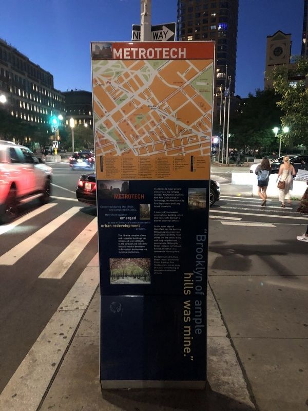
MetroTech
Conceived during the 1980s and completed in 2004, MetroTech quickly emerged as one of America's most successful urban redevelopment projects.
The 16th-acre complex of new and renovated buildings has introduced over 6,000 jobs to the borough and linked the historic heart of downtown to Brooklyn's businesses and technical institutions.
In addition to major private enterprises, the complex includes Polytechnic Institute, New York City College of Technology, the New York City Fire Department and Long Island University.
It is served by an award-winning hotel building, which also houses the borough's district attorney's offices.
On the outer edge of MetroTech lies the bustling Willoughby Street corridor. One hundred and fifty retail stores line the street, many with long neighborhood associations. Willoughby Street connects to Flatbush Avenue, Brooklyn's key commercial thoroughfare.
The landmarked Duffield Street houses and former City of Brooklyn Fire Headquarters join an array of restaurants offering an international selection of foods.
"Brooklyn of ample hills was mine."
Crossing Brooklyn Ferry
Walt Whitman
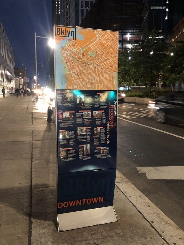
Downtown Brooklyn
is a cluster of extraordinary neighborhoods
1. Fulton Landing
The Fulton Ferry Landing sets a residential neighborhood and commercial waterfront against world-class views of the Brooklyn Bridge, lower Manhattan, and New York Harbor.
Historic Fulton Ferry Pier, Brooklyn Bridge Anchorage, Empire State Park and Barge Music compete with the landing's restaurant row and surrounding historic structures.
2. DUMBO
"Down Under the Manhattan Bridge Overpass"
Local artists named the neighborhood in the 1980s, as they began flocking to this industrial relic.
Blends a gritty industrial past with urban chic: Belgian block streets, old train rails, former warehouses.
Bustling with the creative vibrancy of artists, theaters, restaurants, boutiques and two waterfront parks, Brooklyn's DUMBO amazes with breathtaking views of the Manhattan skyline.
4. Vinegar Hill
Remains a rare living example of an early 19th-century commercial and residential waterfront neighborhood.
Set on Belgian block streets, the storefonts and townhouses reveal a rich history of self-reliance.
To attract Irish immigrants, the neighborhood was named after Ireland's 1798 failed Battle of Vinegar Hill.
Later the area became home to Brooklyn Navy Yard workers.
4. Brooklyn Heights
Colonized by the Dutch in the mid-1600s,

Photographed By Devry Becker Jones (CC0), September 10, 2021
2. Downtown Brooklyn side of the marker
Crowds flock to the world-famous Promenade for its panoramic views of New York Harbor.
Replete with 19th century brownstones, Federal-style frame buildings and architecturally significant churches, Brooklyn Heights became the first New York City Historic District and a national landmark.
5. Brooklyn Civic Center
Brooklyn Hall, formerly Brooklyn City Hall and one of America's finest structures, dominates this center of government.
The imposing landmarked United States Post Office and Court House establish this as a center for City, State and Federal judicial system.
Statues of Henry Ward Beecher, Christopher Columbus, Robert Kennedy and the city's unique Brooklyn War Memorial glorify Cadman Plaza Park.
6. MetroTech
Stands out as Brooklyn's vibrant corporate, academic, retail and government center.
The Commons and adjacent cafes offer art exhibits, concerts and civic events.
Built around The Commons, a 3½ acre tree-filled park near the heart of Downtown Brooklyn, the 10-block MetroTech area is visited daily by over 75,000 people.
7. Cobble Hill
The Dutch granted settlers patents to farm this land in the 1640s.
From his outpost at Cobble Hill Fort, George Washington observed defeat of his troops in the Battle of Brooklyn.
Alfred T. White's modeled tenements and cottages, 1870s affordable housing for working men, contrast strongly to the brownstones of Cobble Hill.
Attracted by the 1950s preservation movements, multi-cultural residents moved into the Greek Revival and Italianate row houses.
8. Fulton Street
Welcoming 100,000 shoppers daily, the area is served by 14 subway and 11 bus lines with over 7,500 parking spaces. It continues to offer New Yorkers a variety of shopping experiences.
Established as New York City's first pedestrian mall, the Fulton Street Mall continues to be one of Brooklyn's busiest Shopping districts.
Fulton Street is strategically located in the center of Downtown Brooklyn.
9. Boerum Hill
It's 44 block of restaurants, chic boutiques and Atlantic Avenue antique shops.
Offering one of New York's most distinctive friendly, small-scale atmospheres.
The 19th century brownstone row houses and red-brick homes qualified Boerum Hill as a designated New York City Historic District and placed it on the National Register of Historic Places.
Close to Atlantic Avenue centers of transportation, shopping and entertainment, the neighborhood is enhanced by a vibrant international music and art scene.
10. Carroll Gardens
Colorful 33-foot gardens and trees are set against 19th century row houses in this neighborhood.
Settled by Irish Americans, replaced by Italian Americans, the area had been known as South Brooklyn.
In the 1960s, renamed for Charles Carroll, a Revolutionary War hero from Maryland who sent troops to fight in the Battle of Brooklyn.
11. Fort Greene
A juxtaposition of rich history and bustling modernity, this 18th century enclave now fosters an exciting 21st-century lifestyle.
With its diverse population and stability, Fort Green invites visitors to experience the local architecture, shops, restaurants, and trend-setting international entertainment.
12. Clinton Hill
Elegant Romanesque mansions built by kings of industry brush against simple pre-Civil War era frame houses.
Students from resident colleges add a cultural and intellectual mix to this New York City Historic District (designated 1981).
Apartment housing opened the neighborhood to more diversity.
Erected by Downtown Brooklyn Partnership. (Marker Number 6.)
Topics. This historical marker is listed in these topic lists: Charity & Public Work • Industry & Commerce • Settlements & Settlers • Waterways & Vessels. A significant historical year for this entry is 2004.
Location. 40° 41.61′ N, 73° 58.985′ W. Marker is in Brooklyn, New York, in Kings County. It is in Brooklyn Heights. Marker is at the intersection of Myrtle Avenue and Flatbush Avenue Extended, on the right when traveling east on Myrtle Avenue. Touch for map. Marker is at or near this postal address: 160 Myrtle Avenue, Brooklyn NY 11201, United States of America. Touch for directions.
Other nearby markers. At least 8 other markers are within walking distance of this marker. Ida B. Wells (within shouting distance of this marker); Did You Know? (about 500 feet away, measured in a direct line); a different marker also named MetroTech / Downtown Brooklyn (about 600 feet away); Wunsch Hall, Tandon School of Engineering (about 600 feet away); The Old Bridge Street Church (about 700 feet away); a different marker also named Did You Know? (approx. 0.2 miles away); New York University Tandon School of Engineering (approx. 0.2 miles away); a different marker also named MetroTech / Downtown Brooklyn (approx. ¼ mile away). Touch for a list and map of all markers in Brooklyn.
Related markers. Click here for a list of markers that are related to this marker. Several identical markers can be found nearby.
Credits. This page was last revised on March 13, 2024. It was originally submitted on September 12, 2021, by Devry Becker Jones of Washington, District of Columbia. This page has been viewed 163 times since then and 9 times this year. Photos: 1, 2. submitted on September 12, 2021, by Devry Becker Jones of Washington, District of Columbia.
Editor’s want-list for this marker. Clear, daylight photos of the marker • Clear, daylight photos of the marker in context • Can you help?
