Old Saybrook Center in Middlesex County, Connecticut — The American Northeast (New England)
Battlefields of the Pequot War
Siege and Battle of Saybrook Fort Historical Route
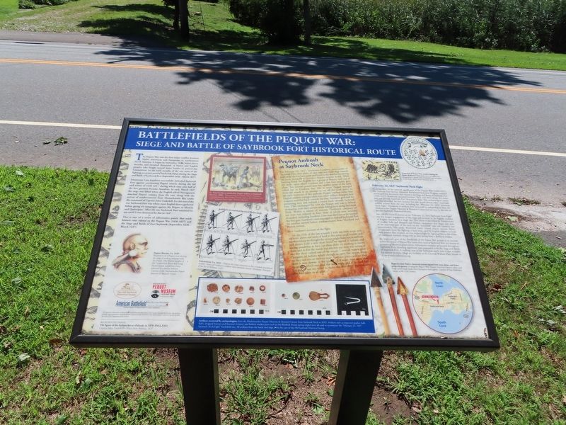
The Pequot War was the first major conflict between Native Americans and Europeans in northeastern North America. It began in September 1636, lasted eleven months, and involved thousands of Native and English peoples who fought several major battles in present-day Connecticut. In the early months of the war most of the fighting occurred about a half-mile east of this marker during the Siege and Battle of Saybrook Fort (September 1636 - March 1637).
Lieutenant Lion Gardiner successfully defended Saybrook Fort against unrelenting Pequot attacks during the fall and winter of 1636-1637, during which time over half of the fort garrison became casualties. In early March 1637 the siege was lifted when the English-allied Narragansett attacked Pequot country from the east, along with the arrival of reinforcements from Massachusetts Bay under the command of Captain John Underhill. For the rest of the war Saybrook Fort was where most English forces gathered before going on campaigns against the Pequot at Mistick and Quinnipiac. After the war Saybrook Fort remained in use until it was destroyed by fire in 1647.
This is one of a series of informative panels that mark historic sites related to the Pequot War (1636-1637) and the Siege and Battle of Fort Saybrook (September 1636 - March 1637).
Pequot Ambush at Saybrook Neck
On February 22, 1637, Lieutenant Gardiner, commander of Saybrook Fort, led a party of nine men and three dogs towards Saybrook Neck to burn reeds and brush in the marshes bordering the neck, ironically to prevent a Pequot surprise attack. While burning brush the English saw a group of Pequot rush out of the reeds, upon which Gardiner and a few men quickly gave chase. Two sentries posted near the smallest point of the neck called out to Gardiner that 100 or more Pequot emerged from the marsh in an attempt to cut off the work party. In the early moments of this ambush, Pequot warriors killed four English soldiers outright while two other soldiers dropped their weapons and fled back towards the fort. Gardiner gathered his remaining men and ordered a retreat back towards Saybrook Fort. They exchanged fire with the Pequot and had to defend themselves with their swords while falling back along Saybrook Neck. Within a matter of minutes Gardiner's company of ten men was reduced to four; three of which were seriously wounded, including Gardiner. One man died just as he reached the fort gate. Gardiner's men managed to defend Saybrook Fort for another month before reinforcements from Hartford and Boston arrived.
Lion Gardiner's account of the fight:
...on the 22th of the last moneth I with ten men more with me went above our neck of land to fire some small bushes and marshes whear we thought the enimie might have lien in ambush and aboute halfe a mile from home we started 3 Indians and having possibility to have cut them short we running to meete them and to fire the marsh but whylest our men was setting it one fire there rushed out of the woods 2 severall ways a great Company of Indians which though we gave fire uppon them yet they run one to the very mussIs of our pieces and soe they shott 3 men downe in the place and 3 more men shott that escaped which one died the same night and if the lord had not put it not my mind to make the men draw their swords they had taken us all alive...
February 22, 1637 Saybrook Neck Fight
In recognition of the national significance of the Pequot War (1636-1637), the National Park Service, American Battlefield Protection Program awarded several grants to document sites related to the Siege and Battle of Saybrook Fort (1636-1637). Fieldwork occurred between 2012 and 2013 along this street and east towards Saybrook Fort Monument Park. The archaeological survey not only identified the fort location but also found several other important combat actions from the war, including the “February 22, 1637 Saybrook Neck Fight.” Hundreds of artifacts were recovered by archaeologists from the Mashantucket Pequot Museum & Research Center and are now in the care of the Old Saybrook Historical Society.
Site 106-35, Locus B, known as the “February 22, 1637 Saybrook Neck Fight” was the longest engagement of the siege and resulted in the highest number of English casualties in a single day. The Locus is identified by distributions of musket balls and dropped and broken equipment that begin just west of the narrowest part of the neck on the mainland” side and continue east approximately 550 yards. Recovered battle related objects include fifteen musket balls from the fighting, a lead wrap used by English soldiers to hold their musket flint in place, an iron strike-a-light for lighting fires or the wicks of matchlock muskets, along with an iron spring from a flintlock musket.
An important goal of the Battlefields of the Pequot War project is to increase public awareness of Pequot War battle sites, such as Saybrook Fort, as a means of promoting historical preservation. Informative markers are located throughout Saybrook Point detailing significant sites associated with the Siege and Battle of Saybrook Fort. A walking tour of the Saybrook battle sites is also available for visitors to enjoy. Maps are available at the General William Hart House or at www.saybrookhistory.org.
( photo captions )
Lt. Lion Gardiner attacked by Pequot Indians at Saybrook Fort, Ca. 1890 – This painting by Charles Stanley Reinhart, commissioned by the Gardiner family, depicts the February 22, 1637 Saybrook Neck Fight. (Private collection)
Depiction of Pequot War combat during the Battle of Mistick Fort taken from an engraving designed by Captain John Underhill and included in his book, Newes From America, 1638.
Instructions, Ca. 1642 — Depicts the steps necessary to fire a loaded matchlock musket. Some of Gardiner’s soldiers were similarly armed. (Hexham, Principles of the Art of Military, 1642)
Reproduction Native American arrows tipped with iron, stone, and brass projectile points. During the Pequot War, Native American warriors often used brass arrow heads made from European trade goods. Courtesy of Tom Nedweden, Society of the 17th Century
Pequot Warrior, Ca. 1620 — Illustration of a Pequot man during the time of trading relations with the Dutch. The Native peoples of the Connecticut River and Long Island Sound would have been adorned in a similar fashion. Courtesy of the Mashantucket Pequot Museum & Research Center
Artifacts recovered by archaeologists from the Mashantucket Pequot Museum & Research Center from Saybrook Neck in 2013. Artifacts such as impacted musket balls (left), dropped buttons and fasteners (center), and broken musket parts such as this flintlock frizzen spring (right) were all used to reconstruct the “February 22, 1637 Saybrook Neck Fight” battlefield site. All artifacts from the battle and siege are in the care of the Old Saybrook Historical Society.
Background Image: The figure of the Indians fort or Palizado in New England Captain John Underhill • Newes from America, 1637
Topics. This historical marker is listed in these topic lists: Forts and Castles • Native Americans. A significant historical date for this entry is February 22, 1637.
Location. 41° 17.014′ N, 72° 22.125′ W. Marker is in Old Saybrook, Connecticut, in Middlesex County. It is in Old Saybrook Center. Marker is on Main Street (Connecticut Route 154) east of East Street, on the left when traveling east. Touch for map. Marker is at or near this postal address: 500 Main Street, Old Saybrook CT 06475, United States of America. Touch for directions.
Other nearby markers. At least 8 other markers are within walking distance of this marker. Doctor Samuel Eliot House (within shouting distance of this marker); The First Church of Christ in Saybrook (approx. 0.4 miles away); Anna Louise James (approx. 0.4 miles away); In this shop… (approx. 0.4 miles away); Old Saybrook Historical Society (approx. 0.4 miles away); Third Meetinghouse (approx. 0.4 miles away); Say-Brooke (approx. 0.4 miles away); a different marker also named Battlefields of the Pequot War (approx. 0.4 miles away). Touch for a list and map of all markers in Old Saybrook.
Also see . . .
1. Old Saybrook Historical Society. (Submitted on September 16, 2021, by Michael Herrick of Southbury, Connecticut.)
2. Saybrook Fort & the Pequot War. (Submitted on September 22, 2021, by Michael Herrick of Southbury, Connecticut.)
3. Fort Saybrook Monument Park – Visit CT. (Submitted on September 22, 2021, by Michael Herrick of Southbury, Connecticut.)
4. Pequot War (Wikipedia). (Submitted on September 16, 2021, by Michael Herrick of Southbury, Connecticut.)
Credits. This page was last revised on February 10, 2023. It was originally submitted on September 16, 2021, by Michael Herrick of Southbury, Connecticut. This page has been viewed 172 times since then and 22 times this year. Photos: 1, 2. submitted on September 16, 2021, by Michael Herrick of Southbury, Connecticut.

