Concord in Middlesex County, Massachusetts — The American Northeast (New England)
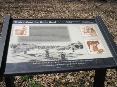
Trades along the Battle Road
Minute Man Natíl Hist Park, Mass
From the late 17th century until the 19th century, there was a tannery at this site near Elm Brook. At the time of the Battle, it was run by Joshua Brooks. The brook provided water to wash leather hides, and to fill large vats in which the hides were tanned. The Brooks family also ran a nearby slaughterhouse, a brick kiln for baking bricks, and a saw mill. All of these are examples of local Colonial industries. Few people in the 18th century were solely farmers. Most men supplemented their income through trades such as shoe making, cabinet making, rope making, or blacksmithing. Many local men worked here at the tannery. Women made dairy products, spun and wove wool and linen cloth, and practiced midwifery. There was a very lively local exchange of goods and services.
“I, Benjamin Brown, Jr. of Lincoln . . . a minor, Hath put himself to Apprentice . . .
to learn tanning and curreing Art, Trade or Mystery . . . ”
-- Benjamin Brown Jr. at age 15, 1762
Erected by Minute Man National Historical Park.
Topics. This historical marker is listed in these topic lists: Colonial Era • War, US Revolutionary. A significant historical year for this entry is 1775.
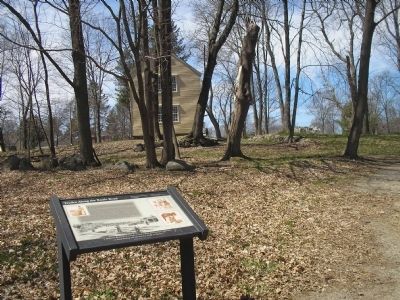
Location. 42° 27.213′ N, 71° 18.28′ W. Marker is in Concord, Massachusetts, in Middlesex County. Marker can be reached from N Great Road (Massachusetts Route 2A), on the right when traveling west. Marker is located along the Battle Road, near Brooks Village. Touch for map. Marker is in this post office area: Concord MA 01742, United States of America. Touch for directions.
Other nearby markers. At least 8 other markers are within 2 miles of this marker, measured as the crow flies. Brooks Historical Area (approx. 0.2 miles away); Landscape Changes (approx. 0.2 miles away); Bloody Angle (approx. 0.6 miles away); Hartwell Tavern Historical Area (approx. 0.6 miles away); Meriamís Corner (approx. 0.9 miles away); a different marker also named Meriamís Corner (approx. 1.1 miles away); a different marker also named Meriamís Corner (approx. 1.1 miles away); Henry David Thoreau (approx. 1.1 miles away). Touch for a list and map of all markers in Concord.
More about this marker. Pictures on both sides of the markers depict colonial men and women practicing their trades, including Tanning, Coopering or Barrel Making, Spinning on a Spinning Wheel and Shoeing a horse.
Also see . . .
1. Minute Man National Historical Park. National Park Service website. (Submitted on May 2, 2009, by Bill Coughlin of Woodland Park, New Jersey.)
2. Battle of Concord. (Submitted on May 2, 2009, by Bill Coughlin of Woodland Park, New Jersey.)
3. The Battle of Concord. The American Revolutionary War website. (Submitted on May 7, 2009, by Bill Coughlin of Woodland Park, New Jersey.)
Credits. This page was last revised on June 16, 2016. It was originally submitted on May 2, 2009, by Bill Coughlin of Woodland Park, New Jersey. This page has been viewed 2,854 times since then and 14 times this year. Photos: 1, 2, 3. submitted on May 2, 2009, by Bill Coughlin of Woodland Park, New Jersey.


