Near Petersburg in Prince George County, Virginia — The American South (Mid-Atlantic)
Uprooted by War
Photographed by Bill Coughlin, April 23, 2007
1. Uprooted by War Marker
This marker is within sight of the Petersburg National Battlefield Visitor Center.
- John Haley, 17th Maine Infantry January 26, 1865
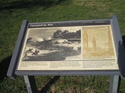
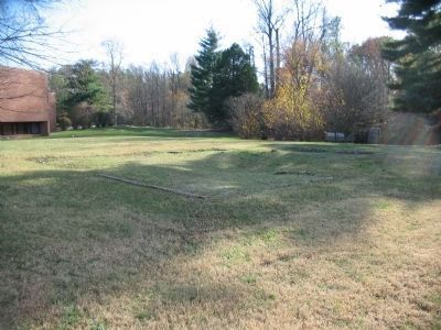
The gentle depression in front of you is the only vestige of the Josiah Jordan House. The house was dismantled by Union troops during the Siege of Petersburg.
War came to the Jordan farm in late 1862, when Confederate engineer Charles Dimmock laid out ten miles of defenses to protect Petersburg. Battery 5 of the “Dimmock Line” stood only yards from theJordan House.
When Union and Confederate armies swarmed over this area in 1864, dozens of farmers like Jordan were uprooted, their homes damaged or destroyed, their woodlots cut, and their fields ravaged. The landscape sill bears the scars.
Erected by National Park Service, U.S. Department of the Interior.
Topics. This historical marker is listed in this topic list: War, US Civil. A significant historical date for this entry is January 26, 1822.
Location. This marker has been replaced by another marker nearby. It was located near 37° 14.667′ N, 77° 21.423′ W. Marker was near Petersburg, Virginia, in Prince George County. It could
this page online

Regionally, this marker was in Coastal Virginia. It was also in the American South, specifically in the Upper South, in the Tidewater, and on the Eastern Seaboard. Globally, it was in the North Atlantic Region, North America, the Western Hemisphere, the Western World, and the Anglosphere. Historically, it found itself in what was once the territory of the Mississippian Culture, one of the original Thirteen Colonies, one of the Confederate States of America, and the Antebellum South.
Other nearby markers. At least 8 other markers are within walking distance of this location: The Petersburg Campaign (a few steps from this marker); Artillery at Petersburg (a few steps from this marker); a different marker also named Uprooted by War (a few steps from this marker); Siege of Petersburg — Grant's First Offensive
Photographed by Bill Coughlin, April 23, 2007
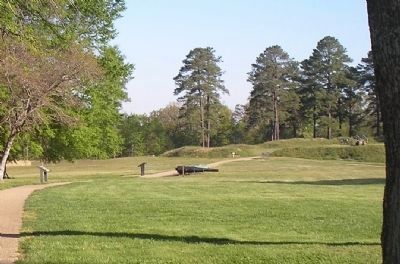
2. Markers on the Battery 5 Trail.
The walking trail that follows the Dimmock Line in the area of Battery 5 passes many markers. The "Uprooted by War" marker is to the left of the photo.
Other markers no longer nearby. Battery 5 Trail (was within shouting distance of this marker but has been replaced with another marker now near it); Battery 5 of the Dimmock Line (was within shouting distance of this marker but has been replaced with another marker now near it); The Siege of Petersburg (was about 300 feet away but has been replaced with another marker now near it).
More about this marker. The left side of the marker contains a picture with the caption The Jordan House appears clearly in this lithograph of the June 15 attack on Battery 5.
The right side of the marker has a picture with the caption The ruins of Edge Hill, five miles west of here, symbolized the fate of many Petersburg-area homes. It was the home of William Turnbull and served as Lee’s last headquarters during the campaign.
Related marker.
Photographed by Bill Coughlin, April 23, 2007
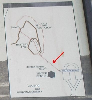
3. Battery 5 Trail Map
The "Uprooted by War" marker, located on the Battery 5 Trail, is indicated by the red arrow.
Also see . . .
1. Petersburg National Battlefield. National Park Service. (Submitted on April 14, 2008, by Bill Coughlin of Woodland Park, New Jersey.)
2. The Siege of Petersburg. (Submitted on April 14, 2008, by Bill Coughlin of Woodland Park, New Jersey.)
Photographed by Craig Swain, November 22, 2008
4. The Jordan House Foundation
The foundation remains are just north of the park visitor center (seen in the left background).
Credits. This page was last revised on October 21, 2024. It was originally submitted on April 14, 2008. This page has been viewed 1,493 times since then and 39 times this year. Last updated on November 11, 2021. Photos: 1, 2, 3. submitted on April 14, 2008, by Bill Coughlin of Woodland Park, New Jersey. 4. submitted on December 22, 2008, by Craig Swain of Leesburg, Virginia. • Bernard Fisher was the editor who published this page.
