Salem in Essex County, Massachusetts — The American Northeast (New England)
Custom House Place
Salem Maritime National Historic Site
— National Park Service, U.S. Department of the Interior —
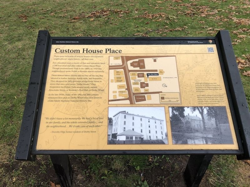
These quiet backyards of historic houses once formed a neighborhood—and a history—all their own.
For a hundred years, a cluster of flats and tenements lined a 200 foot dead-end alley called Custom House Place. Though predominantly Irish in the 1800s, by 1910 this neighborhood spoke Polish or Russian almost exclusively.
These newest Salem citizens did not live off the sea; they labored in leather factories, textile mills, and foundries. They shopped for daily groceries along Derby Street in stores that once sold exotic "India Goods." They frequented the Polish Clubs around newly-named Kosciusko Street, or Kotarski's Pool Hall on Derby Wharf.
In the late 1930s, many of the 19th and 20th century structures here and on Derby Wharf were torn down to create Salem Maritime National Historic Site.
"We didn't have a lot monetarily. We had a lot of love in our family, and the whole extended family…and the neighborhood…We'd take care of each other."
—Dorothy Filip, former resident of Derby Street
[Captions:]
(lower left) According to the 1910 census, no. 10-12 Custom House Place was home to 28 Polish immigrants, 11 of their American-born children, and 69 boarders.
(lower right) Looking at Custom House Place across the backyard of the Custom House, 1935. AT the left is No. 14-16, a double house, and at the right is no. 10-12, a four-story tenement.
Erected by National Park Service, U.S. Department of the Interior.
Topics. This historical marker is listed in these topic lists: Industry & Commerce • Settlements & Settlers • Waterways & Vessels. A significant historical year for this entry is 1910.
Location. 42° 31.319′ N, 70° 53.216′ W. Marker is in Salem, Massachusetts, in Essex County. Marker can be reached from Derby Street just west of Palfrey Court, on the left when traveling east. Touch for map. Marker is in this post office area: Salem MA 01970, United States of America. Touch for directions.
Other nearby markers. At least 8 other markers are within walking distance of this marker. The Hawkes House (a few steps from this marker); Narbonne House (within shouting distance of this marker); Derby House (within shouting distance of this marker); West India Goods Store (within shouting distance of this marker); The Custom House (within shouting distance of this marker); Derby Wharf (within shouting distance of this marker); Home for Aged Women (within shouting distance of this marker); Wharves in the late 1800's (about 300 feet away, measured in a direct line). Touch for a list and map of all markers in Salem.
Credits. This page was last revised on November 19, 2021. It was originally submitted on November 19, 2021, by Devry Becker Jones of Washington, District of Columbia. This page has been viewed 183 times since then and 23 times this year. Photos: 1, 2. submitted on November 19, 2021, by Devry Becker Jones of Washington, District of Columbia.

