
Havana in Gadsden County, Florida — The American South (South Atlantic)
Old Spanish Trail
Southern Borderland Trunkline
| — | Havana, Florida | — |
Photographed by Cosmos Mariner, May 4, 2021
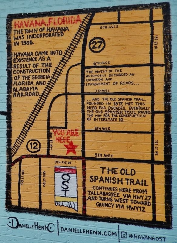
1. Old Spanish Trail Marker
The town of Havana was incorporated in 1906.
Havana came into existence as a result of the construction of the Georgia, Florida and Alabama Railroad.
The advent of the automobile demanded an expansion and improvement of roads…
…and the Old Spanish Trail, founded in 1917, met this need for decades. Eventually the Old Spanish Trail paved the way for the construction of Interstate 10.
Topics. This historical marker is listed in these topic lists: Railroads & Streetcars • Roads & Vehicles • Settlements & Settlers. A significant historical year for this entry is 1917.
Location. 30° 37.45′ N, 84° 24.947′ W. Marker is in Havana, Florida, in Gadsden County. It can be reached from 9th Avenue West just west of North Main Street (U.S. 27), on the right when traveling west. Mural and marker are painted on the south side of the building at this address. Touch for map. Marker is at or near this postal address: 102 North Main Street, Havana FL 32333, United States of America. Touch for directions.

Regionally, this marker is in
this page online
Other nearby markers. At least 8 other markers are within 4 miles of this marker, measured as the crow flies: The Planters Exchange (about 300 feet away, measured in a direct line); Town of Havana (about 400 feet away); POW★MIA (approx. 0.3 miles away); The Price of Freedom Veterans Memorial (approx. 0.3 miles away); Purple Heart (approx. 0.3 miles away); Havana High School Site (approx. 0.3 miles away); Vickers Cemetery (approx. 2.6 miles away); Dr. Malcolm Nicholson Home (approx. 3.4 miles away). Touch for a list and map of all markers in Havana.
Also see . . .
1. Old Spanish Trail — The Story of an Early American Automobile Highway. Florida Back Roads Travel website
Photographed by Cosmos Mariner, May 4, 2021
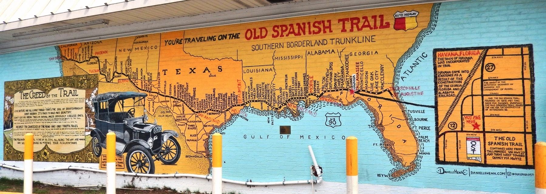
2. Old Spanish Trail Mural
The Old Spanish Trail is an early automobile highway built about 100 years ago. It is sometimes known by the initials OST. When completed, the Old Spanish Trail traveled through 8 states and 67 counties along the southern border of the United States. The early promoters of the highway were fond of saying that the route had been used by the Spanish in the 1500s. It makes a good story, but history does not confirm there was ever a continuous trail across America during the Spanish period.(Submitted on December 19, 2021, by Cosmos Mariner of Cape Canaveral, Florida.)
2. The Old Spanish Trail in Florida. Visit Florida website entry:
In the 1920s, an ambitious transcontinental road project linked St. Augustine and San Diego. Called the Old Spanish Trail, Route 90 provided Jazz Age motorists easy access to the gracious towns strung along the interior of North Florida and beyond. The trail in Florida was an authentic part of the original Spanish route from the 1500s between their settlements in St. Augustine and Pensacola.(Submitted on December 19, 2021, by Cosmos Mariner of Cape Canaveral, Florida.)

Photographed by Cosmos Mariner
3. Mural detail: 1917 Model T Ford

Photographed by Cosmos Mariner
4. Mural detail: The Creed of the Trail

Photographed by Cosmos Mariner, September 22, 2024
5. Old Spanish Trail Mural
Credits. This page was last revised on May 11, 2026. It was originally submitted on December 19, 2021, by Cosmos Mariner of Cape Canaveral, Florida. This page has been viewed 833 times since then and 47 times this year. Photos: 1, 2, 3. submitted on December 19, 2021, by Cosmos Mariner of Cape Canaveral, Florida. 4. submitted on December 20, 2021, by Cosmos Mariner of Cape Canaveral, Florida. 5. submitted on May 11, 2026, by Cosmos Mariner of Cape Canaveral, Florida.
