Parkers Crossroads in Henderson County, Tennessee — The American South (East South Central)
The Battle of Parker's Crossroads
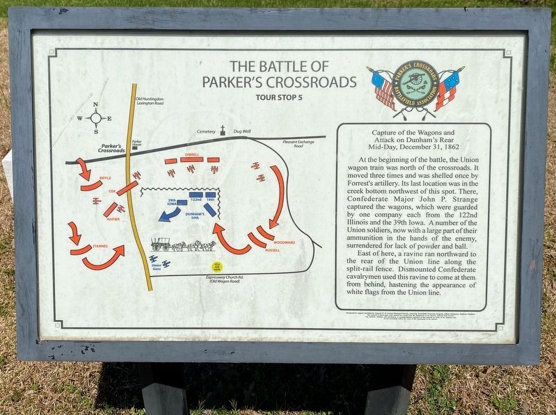
Capture of the Wagons and Attack on Dunham's Rear
— Tour Stop 5 —
Mid-Day, December 31, 1862 At the beginning of the battle, the Union wagon train was north of the crossroads. It moved three times and was shelled once by Forrest's artillery. Its last location was in the creek bottom northwest of this spot. There, Confederate Major John P. Strange captured the wagons, which were guarded by one company each from the 122nd Illinois and the 39th Iowa. A number of the Union soldiers, now with a large part of their ammunition in the hands of the enemy, surrendered for lack of powder and ball.
East of here, a ravine ran northward to the rear of the Union line along the split-rail fence. Dismounted Confederate cavalrymen used this ravine to come at them from behind, hastening the appearance of white flags from the Union line.
Erected by Parkers Crossroads Battlefield Association. (Marker Number 5.)
Topics. This historical marker is listed in this topic list: War, US Civil. A significant historical date for this entry is December 31, 1862.
Location. 35° 46.985′ N, 88° 23.246′ W. Marker is in Parkers Crossroads, Tennessee, in Henderson County. Marker can be reached from Expressway Church Road, 0.8 miles west of Wildersville Road, on the right when traveling west. Located beside a circular driveway into the park. Touch for map. Marker is in this post office area: Wildersville TN 38388, United States of America. Touch for directions.
Other nearby markers. At least 8 other markers are within walking distance of this marker. 7th Wisconsin Light Artillery (about 500 feet away, measured in a direct line); Forrest Averts Disaster (about 500 feet away); Union Wagon Train (about 500 feet away); Russell & Woodward's Advance (about 500 feet away); The Confederate Escape (approx. 0.2 miles away); Dunham's Position (approx. 0.2 miles away); Surprise and Chaos (approx. 0.2 miles away); The Federal Forces (approx. 0.2 miles away). Touch for a list and map of all markers in Parkers Crossroads.
Related marker. Click here for another marker that is related to this marker.
Additional keywords. Forrest
Credits. This page was last revised on December 26, 2021. It was originally submitted on January 3, 2013, by David Graff of Halifax, Nova Scotia. This page has been viewed 585 times since then and 17 times this year. Last updated on December 25, 2021, by David Austin of Scotts Hill, Tennessee. Photos: 1. submitted on May 28, 2021, by Shane Oliver of Richmond, Virginia. 2. submitted on August 22, 2015, by Brandon Fletcher of Chattanooga, Tennessee. 3. submitted on January 3, 2013, by David Graff of Halifax, Nova Scotia. • Mark Hilton was the editor who published this page.


