Southbury in New Haven County, Connecticut — The American Northeast (New England)
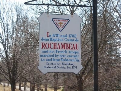
Rochambeau Route 1781-82
Erected 1993 by Southbury Historical Society Inc.
Topics and series. This historical marker is listed in this topic list: War, US Revolutionary. In addition, it is included in the The Washington-Rochambeau Route series list. A significant historical year for this entry is 1781.
Location. 41° 30.21′ N, 73° 12.736′ W. Marker is in Southbury, Connecticut, in New Haven County. Marker is at the intersection of Main Street North (U.S. 6) and Dublin Hill Road, on the left when traveling north on Main Street North. Touch for map. Marker is in this post office area: Southbury CT 06488, United States of America. Touch for directions.
Other nearby markers. At least 8 other markers are within 3 miles of this marker, measured as the crow flies. First Settlers of Southbury (approx. 0.8 miles away); Heritage Village Veterans Memorial (approx. 1.3 miles away); Bullet Hill School (approx. 1˝ miles away); In Memory Of George Washington (approx. 1.7 miles away); Ancient Trading Path (approx. 1.9 miles away); Glebe House (approx. 2.3 miles away); District No. 2 Schoolhouse (approx. 2.3 miles away); The Common (approx. 2.4 miles away). Touch for a list and map of all markers in Southbury.
More about this marker. Historical marker at the site where General Rochambeau, in command of 5,000 French troops, camped enroute to join General Washington on the Hudson River at Dobbs Ferry, New York. From there the combined forces marched to the siege of Yorktown, Virginia where they forced the British army under General Cornwallis to surrender, ending the revolution.
Regarding Rochambeau Route 1781-82. General Rochambeau and his French troops landed at Newport, Rhode Island, on July 10, 1780. He was held there inactive for a year, owing to his reluctance to abandon the French fleet blockaded by the British in Narragansett Bay. At last, in July 1781, Rochambeau's force finally left Rhode Island, marching across Connecticut to join Washington on the Hudson River at Dobbs Ferry, New York. Then followed the celebrated march of the combined forces and the siege of Yorktown. On September 22, they combined with the Marquis de Lafayette's troops and forced Lord Cornwallis to surrender on October 19.
Credits. This page was last revised on January 15, 2022. It was originally submitted on March 21, 2008, by Michael Herrick of Southbury, Connecticut. This page has been viewed 2,682 times since then and 67 times this year. Last updated on January 13, 2022, by Carl Gordon Moore Jr. of North East, Maryland. Photos: 1, 2, 3. submitted on March 21, 2008, by Michael Herrick of Southbury, Connecticut. • J. Makali Bruton was the editor who published this page.


