Nassau near Lewes in Sussex County, Delaware — The American Northeast (Mid-Atlantic)
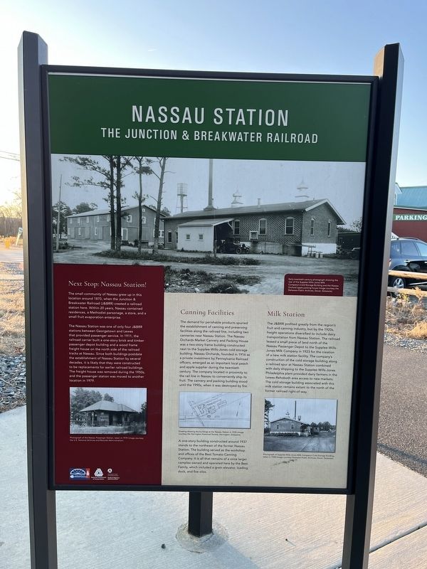
Nassau Station
The Junction & Breakwater Railroad
Next Stop: Nassau Station!
The small community of Nassau grew up in this location around 1870, when the Junction & Breakwater Railroad (J&BRR) created a railroad station here. Within 20 years, Nassau contained residences, a Methodist parsonage, a store, and a small fruit evaporation enterprise.
The Nassau Station was one of only four J&BRR stations between Georgetown and Lewes that provided passenger service. In 1911, the railroad carrier built a one-story brick and timber freight house on the north side of the railroad tracks at Nassau. Since both buildings postdate the establishment of Nassau Station by several decades, it is likely that they were constructed to be replacements for earlier railroad buildings. The freight house was removed during the 1950s, and the passenger station was moved to another location in 1979.
Canning Facilities
The demands for perishable products spurred the establishment of canning and preserving facilities along the railroad line, including two canneries near Nassau Station. The Nassau Orchards Market Cannery and Packing House was a two-story frame building constructed next to the Supplee-Wills-Jones cold storage building. Nassau Orchards, founded in 1916 as a private investment by Pennsylvania Railroad officers, emerged as an important local peach and apple supplier during the twentieth century. The company located in proximity to the rail line in Nassau to conveniently ship its fruit. The cannery and packing building stood until the 1990s, when it was destroyed by fire.
A one-story building constructed around 1937 stands to the northeast of the former Nassau Station. The building served as the workshop and offices of the Best Tomato Canning Company. It is all that remains of a once larger complex owned and operated here by the Best Family, which included a grain elevator, loading dock, and five silos.
Milk Station
The J&BRR profited greatly from the region's fruit and canning industry, but by the 1920s, freight operations diversified to include dairy to include dairy transportation from Nassau Station. The railroad leased a small piece of land north of the Nassau Passenger Depot to the Supplee-Wills-Jones-Milk Company in 1923 for the creation of a new milk station facility. The company's construction of the cold storage building along a railroad spur at Nassau Station combined with daily shipping to the Supplee-Wills-Jones Philadelphia plant provided dairy farmers in the Lewes-Rehoboth area access to new markets. The cold storage building associated with this milk station remains extant to the north of the former railroad right-of-way.
Erected by Delaware Department of Transportation Cultural Resources; Federal Highway Administration, U.S. Department of Transportation.
Topics. This historical marker is listed in these topic lists: Agriculture • Industry & Commerce • Railroads & Streetcars. A significant historical year for this entry is 1870.
Location. 38° 45.109′ N, 75° 11.216′ W. Marker is near Lewes, Delaware, in Sussex County. It is in Nassau. Marker is on Lewes Georgetown Trail just east of Kaeleigh Court, on the left when traveling west. Touch for map. Marker is at or near this postal address: 17239 Queen Anne Way, Lewes DE 19958, United States of America. Touch for directions.
Other nearby markers. At least 8 other markers are within 2 miles of this marker, measured as the crow flies. A History of the Junction & Breakwater Railroad (here, next to this marker); Kiosk Dedicated in Memory of Thomas H. Draper (approx. 0.2 miles away); Broadkiln Hundred (approx. one mile away); Israel United Methodist Church (approx. 1.1 miles away); The Coursey-Daisey Nanticoke Indian Burial Ground (approx. 1.1 miles away); Cool Spring Station (approx. 1.1 miles away); a different marker also named A History of the Junction & Breakwater Railroad (approx. 1.1 miles away); In Honor of Ted Freeman (approx. 1.2 miles away). Touch for a list and map of all markers in Lewes.
Credits. This page was last revised on September 18, 2023. It was originally submitted on January 16, 2022, by Devry Becker Jones of Washington, District of Columbia. This page has been viewed 1,327 times since then and 67 times this year. Photo 1. submitted on January 16, 2022, by Devry Becker Jones of Washington, District of Columbia.
Editor’s want-list for this marker. A wide shot of the marker in context. • Can you help?
