Winder in Barrow County, Georgia — The American South (South Atlantic)
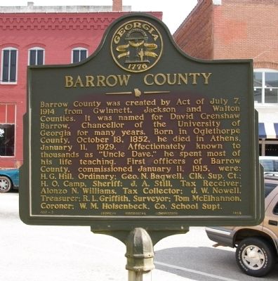
Barrow County
Erected 1956 by Georgia Historical Commission. (Marker Number 007-2.)
Topics and series. This historical marker is listed in these topic lists: Education • Law Enforcement. In addition, it is included in the Georgia Historical Society series list. A significant historical date for this entry is January 11, 1781.
Location. 33° 59.533′ N, 83° 43.273′ W. Marker is in Winder, Georgia, in Barrow County. Marker is at the intersection of North Broad Street (Georgia Route 11) and West Athens Street (Georgia Route 211), on the right when traveling south on North Broad Street. Marker is on the lawn of the Barrow County Courthouse. Touch for map. Marker is at or near this postal address: 30 North Broad Street, Winder GA 30680, United States of America. Touch for directions.
Other nearby markers. At least 8 other markers are within walking distance of this marker. Jackson, Walton, and Gwinnett County Boundary Obelisk (a few steps from this marker); The Stoneman Raid Battle of King's Tanyard (a few steps from this marker); Barrow County War Memorial (a few steps from this marker); Barrow County Courthouse (within shouting distance of this marker); Historic Barrow County Jail (about 400 feet away, measured in a direct line); Winder Railroad Depot (about 400 feet away); Builder of the Nation (about 500 feet away); Hal Jackson Park (about 700 feet away). Touch for a list and map of all markers in Winder.
Credits. This page was last revised on January 3, 2020. It was originally submitted on May 16, 2009, by David Seibert of Sandy Springs, Georgia. This page has been viewed 1,947 times since then and 42 times this year. Photos: 1, 2. submitted on May 16, 2009, by David Seibert of Sandy Springs, Georgia. 3. submitted on June 8, 2009, by David Seibert of Sandy Springs, Georgia. • Craig Swain was the editor who published this page.


