Dacula in Gwinnett County, Georgia — The American South (South Atlantic)
Hog Mountain Baptist Church
Organized January 14, 1854
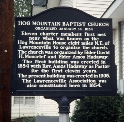
Photographed by David Seibert, April 1991
1. Hog Mountain Baptist Church Marker
The church was organized by Elder David H. Moncrief and Elder Amos Hadaway.
The first building was erected in 1854 with Rev. Amos Hadaway as Pastor for the first eleven years.
The present building was erected in 1905.
The Lawrenceville Association was also constituted here in 1854.
Erected by Hog Mountain Baptist Church.
Topics. This historical marker is listed in this topic list: Religion & Religious Structures. A significant historical year for this entry is 1854.
Location. 34° 3.184′ N, 83° 55.536′ W. Marker is in Dacula, Georgia, in Gwinnett County. It is at the intersection of Hog Mountain Church Road and Braselton Highway (Georgia Route 124), on the right when traveling north on Hog Mountain Church Road. Marker is located at the north side of the church building. Touch for map. Marker is at or near this postal address: 1971 Hog Mountain Church Road, Dacula GA 30019, United States of America. Touch for directions.

Regionally, this marker is in Georgia’s Piedmont and in Metro
this page online
Other nearby markers. At least 8 other markers are within 3 miles of this marker, measured as the crow flies: Fort Daniel (approx. 0.6 miles away); a different marker also named Fort Daniel (approx. 0.6 miles away); Stone Structures (approx. 2.2 miles away); The Elisha Winn House (approx. 2.2 miles away); a different marker also named The Elisha Winn House (approx. 2.2 miles away); a different marker also named The Elisha Winn House (approx. 2.2 miles away); a different marker also named The Elisha Winn House (approx. 2.3 miles away); a different marker also named The Elisha Winn House (approx. 2.3 miles away). Touch for a list and map of all markers in Dacula.

Photographed by David Seibert, April 17, 2009
2. Hog Mountain Baptist Church
Credits. This page was last revised on January 30, 2020. It was originally submitted on May 16, 2009, by David Seibert of Sandy Springs, Georgia. This page has been viewed 1,866 times since then and 66 times this year. Photos: 1, 2. submitted on May 16, 2009, by David Seibert of Sandy Springs, Georgia. • Craig Swain was the editor who published this page.
