Near Big Timber in Sweet Grass County, Montana — The American West (Mountains)
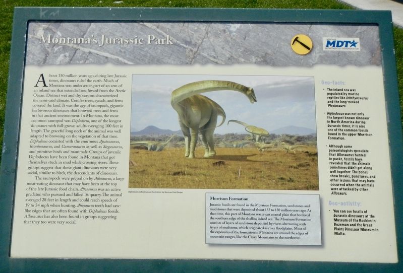
Montana's Jurassic Park
Photographed by Barry Swackhamer, July 23, 2021
1. Montana's Jurassic Park Marker
The sauropods were preyed on by Allosaurus, a large meat-eating dinosaur that may have been at the top
this page online
(side-bar:)
Morrison Formation
Jurassic fossils are found in the Morrison Formation, sandstones and mudstones that were deposited about 155 to 150 million years ago. At that time, this part of Montana was a vast coastal plain that bordered the southern edge of the shallow inland sea. The Morrison Formation consists of layers of sandstone deposited by rivers alternating with lakes of mudstone, which originated as river flood plains. Most of the exposures of the formation in Montana are around the edges of mountain ranges, like the Crazy Mountains to the northwest.
Geo-facts:
• The inland sea was populated by marine reptiles like I•chthyosaurus and the long-necked Plesiosaurs.
• Diplodocus was not only the largest known dinosaur in North America during the Jurassic
Photographed by Barry Swackhamer, July 23, 2021
2. Montana's Jurassic Park Marker
• Although some paleontologists speculate that Allosaurus hunted in packs, fossils have revealed that the animals sometimes didn't get along well together. The bones show breaks, punctures, and other lesions that may have occurred when the animals were attacked by other Allosaurus.
Geo-activity:
• You can see fossils of Jurassic dinosaurs at the Museum of the Rockies in Bozeman and the Great Plains Dinosaur Museum in Malta.
Erected by Montana Department of Transportation.
Topics. This historical marker is listed in this topic list: Paleontology.
Location. 45° 44.049′ N, 109° 45.451′ W. Marker is near Big Timber, Montana, in Sweet Grass County. It can be reached from Interstate 90 at milepost 377, on the right when traveling east. The marker is located at the eastbound Greycliff Rest Area. Touch for map. Marker is in this post office area: Big Timber MT 59011, United States of America. Touch for directions.

Regionally, this marker is in Yellowstone Country. It is also in the American Mountain West and in the Lewis & Clark Corridor. Globally, it is in North America, the Rocky Mountains, the Western Hemisphere, the Western World, and the Anglosphere. Historically, it finds itself in what was once Rupert’s Land and also the Louisiana Purchase.
Other nearby markers. At least 8 other markers are within 2 miles of this marker, measured as the crow flies: The Great Highway of the Northwest: The Yellowstone Trail (within shouting distance of this marker); The Bozeman Trail (within shouting distance of this marker); The Cattle Drive of 1866 (about 700 feet away, measured in a direct line); a different marker also named Montana's Jurassic Park (about 700 feet away); The Crazy Mountains (about 700 feet away); The Crazy Mountains (original title obscured) (about 700 feet away); Captain Wm. Clark (about 700 feet away); a different marker also named The Thomas Party (approx. 2.1 miles away). Touch for a list and map of all markers in Big Timber.
Another marker is no longer nearby. The Thomas Party (was approx. 2.1 miles away but has been replaced with another marker now near it).
Credits. This page was last revised on January 25, 2022. It was originally submitted on January 25, 2022, by Barry Swackhamer of Brentwood, California. This page has been viewed 359 times since then and 32 times this year. Photos: 1, 2. submitted on January 25, 2022, by Barry Swackhamer of Brentwood, California.
