Ocracoke in Hyde County, North Carolina — The American South (South Atlantic)
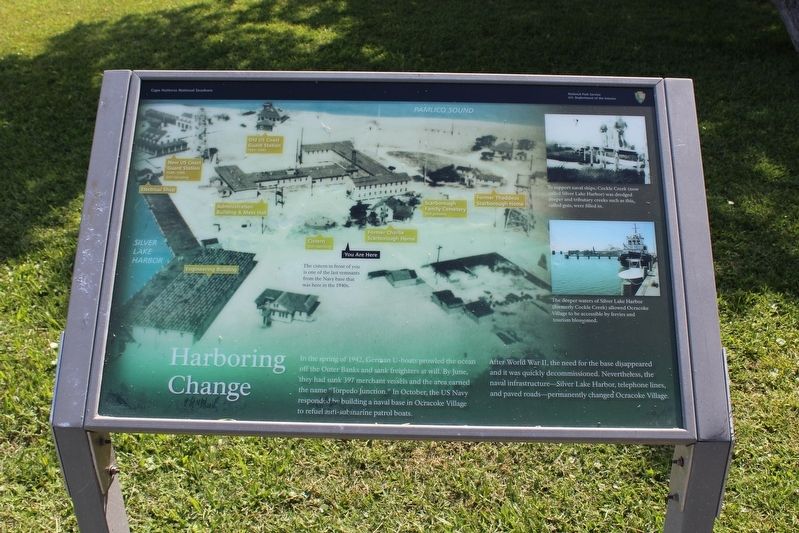
Harboring Change
— Cape Hatteras National Seashore —
After WWII, the need for the base disappeared and it was quickly decommissioned. Nevertheless, the naval infrastructure—Silver Lake Harbor, telephones lines, and paved roads—permanently changed Ocracoke Village.
(captions)
To support naval ships, Cockle Creek (now called Silver Lake Harbor) was dredged deeper and tributary creeks such as this, called guts, were filled in.
The deeper waters of Silver Lake Harbor (formerly Cockle Creek) allowed Ocracoke Village to be accessible by ferries and tourism blossomed.
The cistern in front of you is one of the last remnants from the Navy base that was here in the 1940s.
Erected by National Park Service, U.S. Department of the Interior.
Topics. This historical marker is listed in these topic lists: War, World II • Waterways & Vessels. A significant historical year for this entry is 1942.
Location. 35° 6.978′ N, 75° 59.151′ W. Marker is in Ocracoke , North Carolina, in Hyde County. Marker is at the intersection of Pilottown Circle and Irvin Garish Highway (State Highway 12), on the left when traveling north on Pilottown Circle. Marker located near the Ocracoke Island Visitors Center. Touch for map. Marker is at or near this postal address: 38 Irvin Garish Highway, Ocracoke NC 27960, United States of America. Touch for directions.
Other nearby markers. At least 8 other markers are within walking distance of this marker. Lt. Robert Maynard (within shouting distance of this marker); USRC Mercury (within shouting distance of this marker); Welcome to Ocracoke… (about 400 feet away, measured in a direct line); Late 19th Century Cistern (about 400 feet away); Journey to the original Down East… (about 400 feet away); Ocracoke Windmills (about 400 feet away); Welcome to picturesque Ocracoke Island… (about 400 feet away); Ship's Rudder (about 400 feet away). Touch for a list and map of all markers in Ocracoke.
Also see . . . Cape Hatteras National Seashore Visitor Centers. National Park Service (Submitted on January 30, 2022.)
Credits. This page was last revised on January 30, 2022. It was originally submitted on January 30, 2022, by Tom Bosse of Jefferson City, Tennessee. This page has been viewed 154 times since then and 29 times this year. Photos: 1, 2, 3. submitted on January 30, 2022, by Tom Bosse of Jefferson City, Tennessee. • Bernard Fisher was the editor who published this page.


