Richmond Heights in St. Louis County, Missouri — The American Midwest (Upper Plains)
Service Roster
In honor and memory of those who served during World war 1914-1918
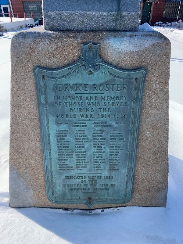
Photographed by Thomas Smith, February 5, 2022
1. Service Roster Marker
★ Lee T. Goff • ★ Charles Gray • ★ Walter M. Rupert • ★ Mamual Johnson • ★ Roy G. Winzenburg • ★ Roy E. Lile
C.W. Backland • Charles Bante • A.J. Biggs • Chester Brewer • Sammel Brewer • Victor Brewer • Edward Buckhnan • Kenneth E. Buchanan • Edward A. Buehning • Walter A. Buehning • Walter Craig • L.F. Davis • Earl Dickson • Milton Doerraum • Raymond F. Doerbaum • F.C. Douglas • Phil Forkner • A.M. Gloeckner • Frank L. Grutson • Raymond D. Grutsch • Raymond D. Grutsch • Harry Hall • G.W. Hansen • C.F. Herr • Raymond Herr • Austin Hoffman • James Horton • Frank Horton • Russell E. Hughes • William C. Hunter • Henry Johnson • H.D. Kerr • F.R. Lindenstein • Roy Manners • John Martin • Charles Maurer • Ralph McCarhey • Harry O. Moline • John Moore • J.J. Moroney • S.H. Morton Jr. • Arley Norris • F.A. O'Connell • James C. O'Keefe • Lester A O'Keefe • Fred Olsen • E.D. Owens • A.A. Robinson • H. Siebert • William Shore • Hans Sorrenster • Edward Stellweg • Fredric D. Stillman • Albert Stmeck • Harry Turner • Glenwood F. Yoges • Homer Ward • Lee Weaver • P.A. Williams • Walter Wilson •
this page online
Erected 1923 by Citizens of the City of Richmond Heights.
Topics. This memorial is listed in this topic list: War, World I.
Location. 38° 37.43′ N, 90° 19.272′ W. Memorial is in Richmond Heights, Missouri, in St. Louis County. It is at the intersection of South Big Bend Boulevard and Bruno Avenue, on the left when traveling north on South Big Bend Boulevard. Touch for map. Memorial is at or near this postal address: 1717 S Big Bend Blvd, Saint Louis MO 63117, United States of America. Touch for directions.

Regionally, this memorial is in Greater St. Louis. It is also in the American Midwest, in the Lewis & Clark Corridor, in the Corn Belt, and in the Great River Road Region. Globally, it is in North America, the Western Hemisphere, the Western World, and the Anglosphere. Historically, it finds itself in what was once the Viceroyalty of New France, the territory of the Mississippian Culture, the Louisiana Purchase, and the Antebellum South.
Other nearby markers. At least 8 other markers are within walking distance of this marker: VFW Post 3500 War Memorial (a few steps from this marker); The Community, Churches, and Schools of the Hadley Township Neighborhood (approx. half a mile away); Richard A. Hudlin and Arthur R. Ashe, Jr. and the Bennett Avenue Historic District (approx. 0.7 miles away); Empire Supply (approx. ¾ mile away); Chain Of Rocks Bridge (approx. ¾ mile away); Fun Fair Park (approx. ¾ mile away); Kalb Electric (approx. ¾ mile away); The Wedge (approx. ¾ mile away). Touch for a list and map of all markers in Richmond Heights.
Credits. This page was last revised on February 14, 2022. It was originally submitted on February 13, 2022, by Thomas Smith of Waterloo, Ill. This page has been viewed 237 times since then and 16 times this year. Photo 1. submitted on February 13, 2022, by Thomas Smith of Waterloo, Ill. • Devry Becker Jones was the editor who published this page.
