Santa Clara in Santa Clara County, California — The American West (Pacific Coastal)
The Five Sites of Santa Clara de Asís Mission
Inscription.
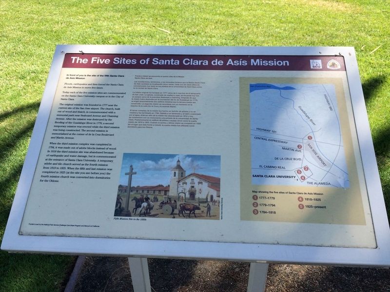
In front of you is the site of the fifth Santa Clara de Asis Mission.
Floods, earthquakes and fires forced the Santa Clara de Asis Mission to move five times.
Today each of the mission sites are commemorated on the Santa Clara University campus or in the City of Santa Clara.
The original mission was founded in 1777 near the current site of San Jose airport. The church, built out of wood and thatch, is commemorated with a memorial park near Seaboard Avenue and Channing Avenue. After the mission was destroyed by the flooding of the Guadalupe River in 1779, a second temporary mission was erected while the third mission was being constructed. The second mission memorialized at the corner of de la Cruz Boulevard and Martin Avenue.
When the third mission complex was completed in 1784, it was made out of adobe block instead of wood. In 1818 the third mission site was abandoned because of earthquake and water damage, but is commemorated at the entrance of Santa Clara University. A temporary adobe and tile church served as the fourth mission from 1819 to 1825. When the last mission was completed in 1825 (at the site you see before you) the fourth mission church was converted into dormitories for the Ohlone.
Las inundaciones, terremotos, y los incendios hicieron que la Misión Santo Clara de Asís cambiara su localización cinco veces. Cada uno de estos sitios es conmemorado hoy tanto en los predios de la universidad de Sant Clara como en la ciudad de Santa Clara.
La misión original fue fundada en 1777 cerca de lo que hoy es el aeropuerto de San José. La iglesia, construida de madera y paja, se recuerda hoy con un parque cerca de la avenidas Seaboard y Channing. Después de que la misión fuera destruida por la inundación del rio de Guadalupe en 1779, se erigió temporalmente otro edificio minetras que la tercera misión era construida. La segunda misión es recordada con un momento en la esquina de la calle De la Cruz y la avenida Martin.
El tercer complejo de la misión fue hecho en ladrillo de adobe y no en madera y que terminado en 1784. Debido a un terremoto y al daño ocasionado por el agua, el Jercer sitio de la misión fue abandonado en 1818 y hoy se conmemora con un monumento a la entrada de la universidad de Santa Clara. Posteriomente un edificio de adobe y azulejo sirvió como la cuarta misión de 1819 a 1825. Cuando la quinta
y última misión misión se completó en 1825 (en el lugar que esta frente a Usted), la cuarta misión fue utilizada como dormitorio para los Ohlone.
Erected by Santa Clara University / Juan Bautista de Anza National Historic Trail.
Topics. This historical marker is listed in these topic lists: Architecture • Churches & Religion • Colonial Era • Disasters • Settlements & Settlers. A significant historical year for this entry is 1777.
Location. 37° 20.982′ N, 121° 56.446′ W. Marker is in Santa Clara, California, in Santa Clara County. Marker is on Palm Drive east of Alvisio Street, on the left when traveling east. Touch for map. Marker is at or near this postal address: 500 El Camino Real, Santa Clara CA 95050, United States of America. Touch for directions.
Other nearby markers. At least 8 other markers are within walking distance of this marker. The Changing Church (here, next to this marker); Original Cross (within shouting distance of this marker); Memorial Roses (within shouting distance of this marker); Mission Santa Clara (within shouting distance of this marker); Father Magin Catala (within shouting distance of this marker); Old Adobe Wall / Olive Trees (about 500 feet away, measured in a direct line); Professor John J. Montgomery (about 600 feet away); Santa Clara Women’s Club Adobe (about 800 feet away). Touch for a list and map of all markers in Santa Clara.
Credits. This page was last revised on April 28, 2022. It was originally submitted on April 12, 2022, by Adam Margolis of Mission Viejo, California. This page has been viewed 165 times since then and 34 times this year. Photos: 1, 2. submitted on April 12, 2022, by Adam Margolis of Mission Viejo, California. • Devry Becker Jones was the editor who published this page.

