
Athens in Athens-Clarke County, Georgia — The American South (South Atlantic)
Water Power
The Headrace and Tailrace
Photographed by Darren Jefferson Clay, June 19, 2021
1. Water Power Marker
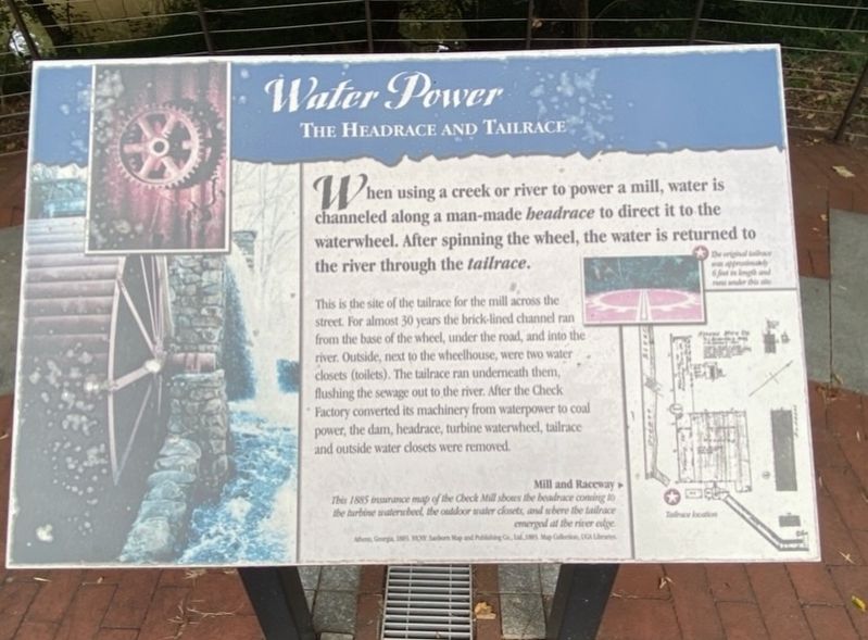
This is the site of the tailrace for the mill across the street. For almost 30 years the brick-lined channel ran from the base of the wheel, under the road, and into the river. Outside, next to the wheelhouse, were two water closets (toilets). The tailrace ran underneath them, flushing the sewage out to the river. After the Check Factory converted its machinery from waterpower to coal power, the dam, headrace, turbine waterwheel, tailrace and outside water closets were removed.
(caption)
Mill and Raceway
This 1885 insurance map of the Check Mill shows the headrace coming to the turbine waterwheel, the outdoor water closets, and where the tailrace emerged at the river edge.
Topics and series. This historical marker is listed in this topic list: Industry & Commerce. In addition, it is included in the If You've Got to Go... series list.
Location. 33° 57.498′ N, 83° 21.969′ W.
this page online

Regionally, this marker is in the Classic City Area and in the Piedmont. It is also in the American South and specifically in the Deep South. Globally, it is in North America, the Western Hemisphere, the Western World, and the Anglosphere. Historically, it finds itself in what was once the territory of the Mississippian Culture, one of the original Thirteen Colonies, one of the Confederate States of America, and the Antebellum South.
Other nearby markers. At least 8 other markers are within walking distance of this marker: Cook & Brother Armory Building (here, next to this marker); Making Things in the Mill (a few steps from this marker); a different marker also named Water Power (a few steps from this marker); a different marker also named Making Things in the Mill (a few steps from this marker); a
Photographed by Darren Jefferson Clay, June 19, 2021
2. Water Power Marker
Credits. This page was last revised on April 21, 2022. It was originally submitted on April 17, 2022, by Darren Jefferson Clay of Duluth, Georgia. This page has been viewed 244 times since then and 22 times this year. Photos: 1, 2. submitted on April 17, 2022, by Darren Jefferson Clay of Duluth, Georgia. • Bernard Fisher was the editor who published this page.
