Cambridge in Waterloo Region, Ontario — Central Canada (North America)
Black Bridge Road Bridge
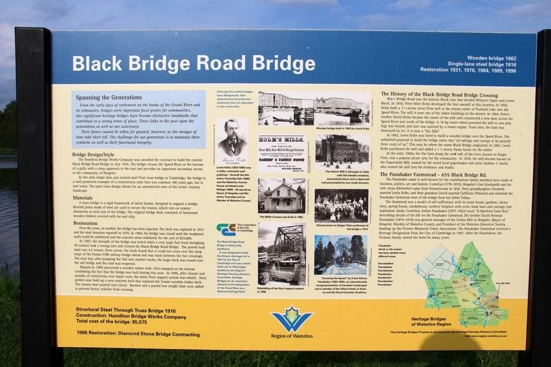
From the early days of settlement on the banks of the Grand River and its tributaries, bridges were important focal points for communities. Our significant heritage bridges have become distinctive landmarks that contribute to a strong sense of place. These links to the past span the generations as well as our waterways.
Their future cannot be taken for granted, however, as the ravages of time take their toll. The challenge for our generation is to maintain their symbolic as well as their functional integrity.
Bridge Design/Style
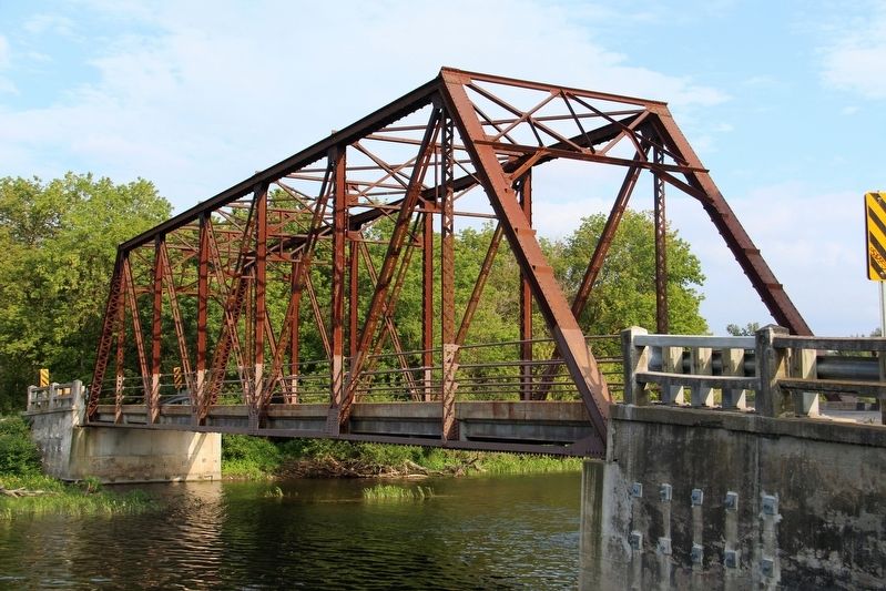
The Hamilton Bridge Works Company was awarded the contract to build the current Black Bridge Road Bridge in July 1916. The bridge crosses the Speed River at the bottom of a gully with a steep approach to the east and provides an important secondary access to the community of Hespeler.
As the only single-lane, pin-jointed steel Pratt truss bridge in Cambridge, the bridge is a well-preserved example of a construction style that was common 100 years ago, but is rare today. The open truss design allows for an unrestricted view of the scenic country landscape.
Materials
A truss bridge is a rigid framework of metal beams, designed to support a bridge. Riveted joints made of steel are used to secure the trusses, which rest on cement abutments at each end of the bridge. The original bridge deck consisted of laminated wooden timbers covered with tar and chip.
Restoration
Over the years, as needed, the bridge has been repaired. The deck was replaced in 1931 and the steel structure repaired in 1976. In 1984, the bridge was closed until the weakened walls could be reinforced and the concrete areas stabilized, for the cost of $25,000.
In 1987, the strength of the bridge was tested when a very large fuel truck (weighing 70 tonnes) took a wrong turn and crossed the Black Bridge Road Bridge. The posted load limit was 4.5 tonnes. Once across, the truck found that it could not cross over the steep slope of the former CNR railway bridge ahead and was stuck between the two crossings. The next day, after pumping the fuel into smaller trucks, the large truck was towed over the rail bridge and the road was reopened.
Repairs in 1989 uncovered a wooden timber with 1916 stamped on the bottom confirming the fact that the bridge was built during that year. In 1996, after closure and months of controversy over repair costs, the entire floor support system was rebuilt. Steel girders now hold up a new concrete deck that replaced the former wooden timber deck. The trusses were painted rust colour. Barriers and a posted low-weight limit were added to prevent heavy vehicles from crossing.
The
Black Bridge Road was the historic Block Line that divided Wilson's Upper and Lower Block. In 1850, Peter Niles Holm developed the first sawmill at this location. In 1856, Holm built a 3½-storey stone flour mill at the stream outlet of Puslinch Lake into the Speed River. The mill is now one of the oldest buildings in the district. In 1864, Peter's brother David Holm became the owner of the mill and constructed a new dam across the Speed River just north of the bridge. A 30 hp water-wheel powered the mill to saw pine logs into boards and later was assisted by a steam engine. Years later, the dam was destroyed by ice. It is now a "dry falls."
In 1862, Lewis Kribs was hired to build a wooden bridge over the Speed River. The submitted proposal to build the bridge states that "all railings and casings to be painted three coats of tar." This may be where the name Black Bridge originated. In 1882, Lewis Kribs purchased the mill and added a 1½-storey frame house for the miller.
In the early 1900s, the flat land along the west side of the river, known as Stager Flats, was a popular picnic area for the community. In 1978, the mill became known as the Papersmith Mill, named by the noted local papermaker and artist Andrew J, Smith, who turned the mill into his residence and studio.
The Panabaker Farmstead – 655 Black Bridge Rd.
The Panabaker name is well-known for the contributions family members have made in business, politics, art and history. Cornelius (1770-1855), Hespeler's first blacksmith and his wife Anna (Detweiler) came from Pennsylvania in 1810. Their granddaughter Elizabeth married Lewis Kribs, and their grandson David married Catherine (Wanner) and inherited the Panabaker farmstead west of the bridge from her father Tobias.
The farmstead was a model of self-sufficiency with its stone house, gardens, cherry trees, spring house, smokehouse, outdoor fireplace with oven, bank barn and carriage and implement sheds. Cornelius Arthur Panabaker (1877-1963) wrote "A Barefoot Farm Boy" describing details of his life on the Panabaker farmstead. His brother David Norman Panabaker (1874-1939) was general manager of the Forbes Mill in Hespeler, Mayor of Hespeler, Warden of Waterloo County and president of the Waterloo Historical Society heading up the Pioneer Memorial Tower Association. The Panabaker Farmstead received a Heritage Designation from the City of Cambridge in 1987. After the Panabakers, the Tschanz family owned the farm for many years.
Captions
(Top) Wooden bridge built in 1862 by Lewis Kribs.
(Top row)
• Lewis Kribs (1829-1908) was a miller, contractor and politician. He built the Waterloo Township Hall (1868) and the Waterloo County House of Industry and Refuge (1869). He served as Reeve of Hespeler and Waterloo Township and as Warden of Waterloo County.
• The Holm's Mill is Georgian in style with flat headed windows, symmetrical doors and a steel-clad roof punctuated by two small dormers.
(Middle row)
• The Miller's House was built in 1882.
• Church picnic on Stager Flats southwest of the bridge, c. 1910.
(Bottom row)
• Rebuilding of the floor support system in 1996.
• "Crossing the Speed" by Frank Shirley Panabaker (1904-1992), an internationally recognized painter of Canadian landscapes and a member of the Allied Artists of America and the Royal Canadian Academy.
Erected by Region of Waterloo.
Topics. This historical marker is listed in these topic lists: Agriculture • Bridges & Viaducts • Industry & Commerce • Settlements & Settlers. A significant historical month for this entry is July 1916.
Location. 43° 27.066′ N, 80° 17.929′ W. Marker is in Cambridge, Ontario, in Waterloo Region. Marker is on Blackbridge Road, 0.3 kilometers west of Townline Road, on the right when traveling west. Touch for map. Marker is in this post office area: Cambridge ON N0B 1M0, Canada. Touch for directions.
Other nearby markers. At least 8 other markers are within 11 kilometers of this marker, measured as the crow flies. Grand River/‘O:se Kenhionháta:tie/La Rivière Grand (approx. 9.9 kilometers away); Galt City Hall (approx. 10.2 kilometers away); The Honourable James Young 1835-1913 (approx. 10.3 kilometers away); Women's Royal Canadian Naval Service Monument (approx. 10.3 kilometers away); Main Street Bridge (approx. 10.4 kilometers away); Former Galt Post Office/ L’Ancien Bureau de Poste de Galt (approx. 10.4 kilometers away); The Home of the First Mayor of Guelph (approx. 11 kilometers away); Provincial Winter Fair Building (approx. 11.1 kilometers away). Touch for a list and map of all markers in Cambridge.
Credits. This page was last revised on April 23, 2022. It was originally submitted on April 23, 2022, by Duane and Tracy Marsteller of Murfreesboro, Tennessee. This page has been viewed 108 times since then and 11 times this year. Photos: 1, 2. submitted on April 23, 2022, by Duane and Tracy Marsteller of Murfreesboro, Tennessee.
Editor’s want-list for this marker. Wide shot of marker and surrounding area in context. • Can you help?

