Near Brooks in Newell County, Alberta — Canada’s Prairie Region (North America)
The River Runs Dry
The River in the Sky comes down to earth
“So he grabbed hold of a pick, he just kind of lifted it up a bit and then drove it right through, right through the bowl. Well, as the pick went through the bowl his hair stood straight up on end, I can assure you.”The Aqueduct was showing its age. Although the problem of leaky joints had largely been fixed and the coatings on the inside of the shell were holding up fairly well, the Aqueduct had been gradually wearing out from the day it first started carrying water. Much of the concrete in the bowl was rotten, and although the Eastern Irrigation District had replaced just over half of that concrete, the possibility of a break or the structure collapsing under a full load of water worried the District's administrators.
The elegant concrete Aqueduct was replaced with an elevated two-bank earthfill canal and a reinforced concrete inverted siphon that could carry about 50 percent more water. It began operating in 1979. The annual report of the Eastern Irrigation District barely made a mention of the passing of the River in the Sky. “The replacement of the Brooks Aqueduct went on stream in late June,” the report noted between listing repairs to the Bassano Dam and changes made to water rights policy. The River in the Sky had come down to earth.
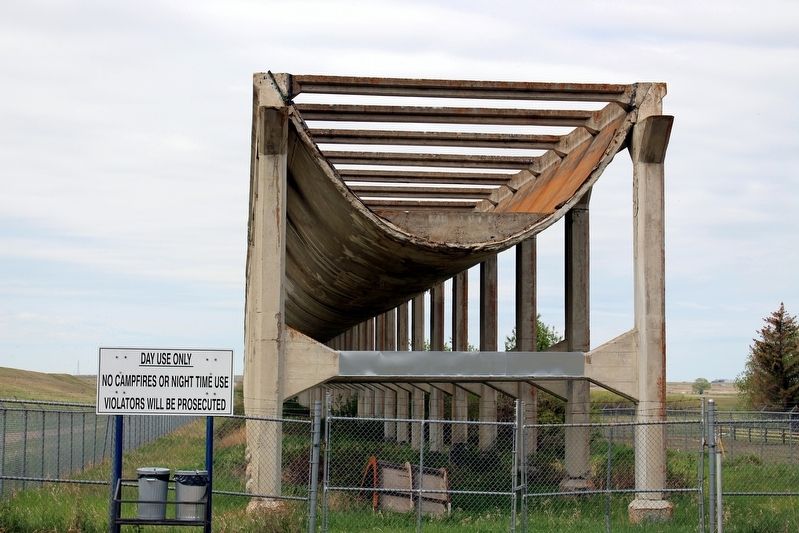
Described by engineers in 1925 as “a peculiar structure which had no exact parallel elsewhere,” the Brooks Aqueduct carried approximately 10 billion cubic metres of water during its lifetime. It was the largest steel reinforced concrete aqueduct in North America. The inverted siphon that sent water swirling under the railway tracks was an early application of reinforced concrete to a complex tubular form supported on a soft soil foundation. The Brooks Aqueduct is, as the Brooks newspaper trumpeted at the time of its completion, “a considerable engineering feat.”
[Box]
How much water?
Engineers estimate 10 billion cubic metres of water flowed through the Aqueduct during its lifetime. This amount of water would fill Sylvan Lake 24 times or Lake Louise 324 times. It would fill just over half of Cold Lake, or barely 1/160 of Lake Athabasca. What it did do year after year was carry water for farmers who needed it.
[Photo captions (left to right)]
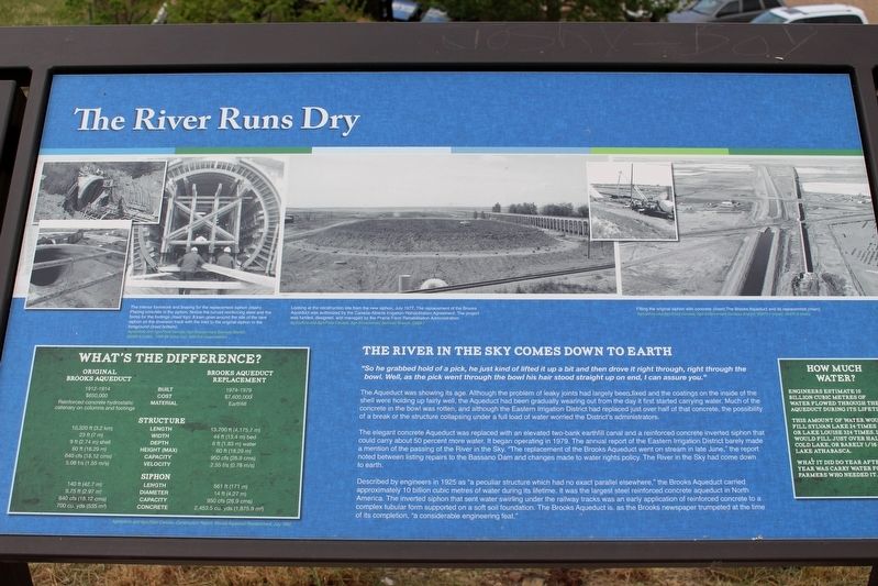
• The interior formwork and bracing for the replacement siphon (main). Placing concrete in the siphon. Notice the curved reinforcing steel and the forms for the footings (inset top). A train goes around the site of the new siphon on the diversion track with the inlet to the original siphon in the foreground (inset bottom). Agriculture and Agri-Food Canada, Agri-Environment Services Branch, 32040-5 (main), 1048-06 (inset

cmh2315fl via Flickr (CC BY-NC 2.0) (cropped), May 30, 2015
2. The River Runs Dry Marker detail
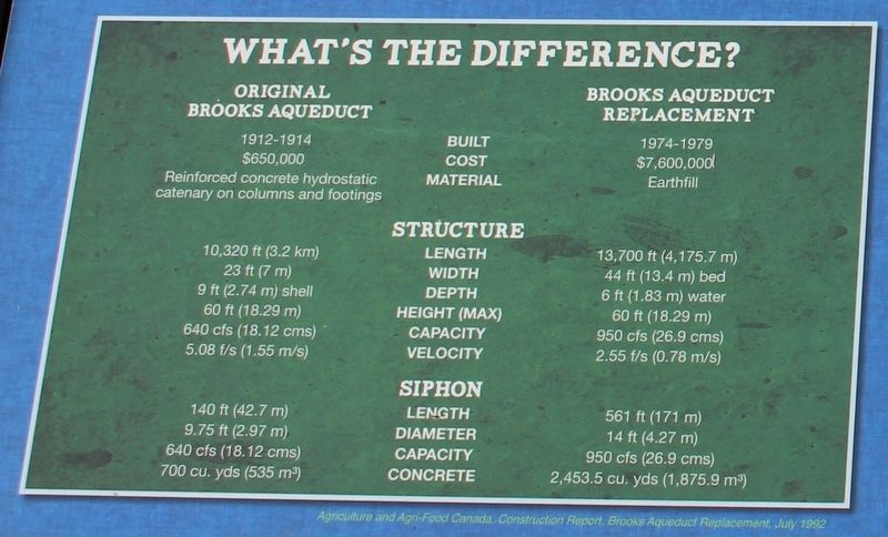
This table compares the original Brooks Aqueduct with its successor.
• Looking at the construction site from the new siphon, July 1977. The replacement of the Brooks Aqueduct was authorized by the Canada-Alberta Irrigation Rehabilitation Agreement. The project was funded, designed, and managed by the Prairie Farm Rehabilitation Administration. Agriculture and Agri-Food Canada, Agri-Environment Services Branch, C869-1
• Filling the original siphon with concrete (inset). The Brooks Aqueduct and its replacement (main). Agriculture and Agri-Food Canada, Agri-Environment Services Branch, 60972-1 (inset), 33475-9 (main)
Erected by Agriculture and Agri-Food Canada, Agri-Environment Services Branch.
Topics. This historical marker is listed in these topic lists: Bridges & Viaducts • Waterways & Vessels. A significant historical year for this entry is 1979.
Location. 50° 31.909′ N, 111° 50.251′ W. Marker is near Brooks, Alberta, in Newell County. Marker is on Range Road 142, 0.4 kilometers south of Township Road 183A Road, on the right when traveling south. Touch for map. Marker is at or near this postal address: 142 Range Rd, Brooks AB T0J 3K0, Canada. Touch for directions.
Other nearby markers. At least 6 other markers are within walking distance of this marker. River in the Sky (here, next to this marker); a different marker also named River in the Sky
Related markers. Click here for a list of markers that are related to this marker.
Credits. This page was last revised on May 1, 2022. It was originally submitted on April 30, 2022, by Duane and Tracy Marsteller of Murfreesboro, Tennessee. This page has been viewed 80 times since then and 7 times this year. Photos: 1, 2, 3. submitted on April 30, 2022, by Duane and Tracy Marsteller of Murfreesboro, Tennessee.
Editor’s want-list for this marker. Wide shot of marker and surrounding area in context. • Can you help?

