Near Brooks in Newell County, Alberta — Canada’s Prairie Region (North America)
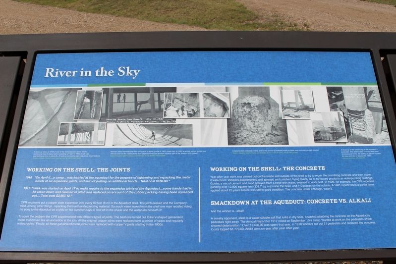
River in the Sky
Working on the shell: The joints
1916 “On April 6 … a camp … was located at the aqueduct for the purpose of tightening and repacking the metal bands at six expansion joints, and also of putting on additional bands … Total cost $160.00.”
1917 “Work was started on April 17 to make repairs to the expansion joints of the Aqueduct … some bands had to be taken down and cleaned of pitch and replaced on account of the rubber packing having been squeezed out … Total cost $2,807.12.”
CPR engineers put a copper plate expansion joint every 80 feet (6 m) in the Aqueduct shell. The joints leaked and the Company tried, among other things, repacking them with waterproofing material. So much water leaked from the shell one man recalled riding his pony to the Aqueduct as a child on hot summer days to cool off in the shade and the waterfalls beneath it!
To solve the problem the CPR experimented with different types of joints. The best one turned out to be V-shaped galvanized metal that moved like an accordion at the join. All the original copper joints were replaced over a period of years and regularly waterproofed. Finally, all these galvanized metal joints were replaced with copper V joints starting in the 1950s.
Working on the shell: The concrete
Year after year work was carried out on the inside and outside of the shell to try to repair the crumbling concrete and then make it waterproof. Workers experimented and sprayed and patched, trying mainly oil or tar-based products as waterproofing coatings. Gunite, a mix of cement and sand sprayed from a hose with water, seemed to work best. In 1926, for example, the CPR reported guniting over 12,000 square feet (339.7 sq. m) inside the bowl, and 112 places on the outside. A 1961 report noted a gunite layer applied about 25 years before was still in good condition. The concrete under it though, wasn't.
Smackdown at the Aqueduct: Concrete vs. Alkali
And the winner is...alkali!
A sneaky opponent, alkali is a water-soluble salt that lurks in dry soils. It started attacking the concrete on the Aqueduct's pedestals right away. The Annual Report for 1917 noted on September 10 a camp “started at work on the pedestals which showed deterioration.” Over $1,400.00 was spent that year. In 1918 workers cut out 31 pedestals and replaced the concrete. Costs topped $1,770.00. And it went on year after year after year.
[Photo captions (left to right)]
• A close-up taken in 1918 of one of the first expansion joints (main), reinforcing steel in place before installing a V joint in 1921 (inset top), and holding a form in place at a V joint so concreting can take place (inset bottom). Eastern Irrigation District Library and Archives, B-156, B-630. B-668
• Workers stand beneath the shell on boards to spray gunite in 1921 (main top). In 1922 a worker sprays gunite over chicken wire on the inside of the shell (main bottom) and workers replace part of the shell in 1935 (inset). Eastern Irrigation District Library and Archives, B-712, B-949, and B-3008B
• A deteriorated pedestal (main), and forms around a pedestal ready to have new concrete poured (insets). Eastern Irrigation District Library and Archives, B-113 (main), B-1762, and B-1763 (insets)
• A close-up of the reinforcing in the Aqueduct's pedestals. The deteriorated concrete has been removed and forms are waiting to be put in place for new concrete to be poured, 1927. Glenbow Archives, NA-4389-36
Erected by Agriculture and Agri-Food Canada, Agri-Environment Services Branch.
Topics. This historical marker is listed in these topic lists: Bridges & Viaducts • Waterways & Vessels. A significant historical date for this entry is April 6, 1916.
Location. 50° 31.703′ N, 111° 51.417′ W. Marker is near Brooks, Alberta, in Newell County. Marker is on Brooks Aqueduct trail, 1.4 kilometers west of Range Road 142. Touch for map. Marker is in this post office area: Brooks AB T0J 3K0, Canada. Touch for directions.
Other nearby markers. At least 6 other markers are within walking distance of this marker. A different marker also named River in the Sky (here, next to this marker); Welcome to the Brooks Aqueduct (approx. 1.4 kilometers away); The Brooks Aqueduct/L’aqueduc de Brooks (approx. 1.4 kilometers away); a different marker also named River in the Sky (approx. 1.4 kilometers away); a different marker also named River in the Sky (approx. 1.4 kilometers away); The River Runs Dry (approx. 1.4 kilometers away).
Related markers. Click here for a list of markers that are related to this marker.
Credits. This page was last revised on May 1, 2022. It was originally submitted on May 1, 2022, by Duane and Tracy Marsteller of Murfreesboro, Tennessee. This page has been viewed 55 times since then and 3 times this year. Photo 1. submitted on May 1, 2022, by Duane and Tracy Marsteller of Murfreesboro, Tennessee.
Editor’s want-list for this marker. Wide shot of marker and surrounding area in context. • Can you help?
