Teotihuacán de Arista in Teotihuacán, Mexico State, Mexico — The Central Highlands (North America)
La Ciudadela
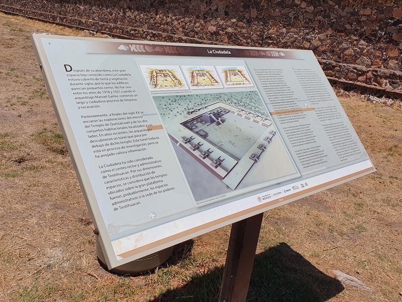
Después de su abandono, este gran espacio hoy conocido como La Ciudadela estuvo cubierto de tierra y vegetación durante siglos, por lo que los edificios parecían pequeños cerros. No fue sino entre los años de 1918 y 1921 cuando el arqueólogo Manuel Gamio comenzó un largo y cuidadoso proceso de limpieza y excavación.
Posteriormente, a finales del siglo XX se iniciaron las exploraciones del interior del Templo de Quetzalcoatl y de los dos conjuntos habitacionales localizados a sus lados. En años recientes, los arqueólogos descubrieron un túnel que pasa por debajo de dicho templo. Este túnel todavía está en proceso de investigación, pero ya ha arrojado valiosa información. La Ciudadela ha sido considerada como el centro rector y administrativo de Teotihuacan. Por sus dimensiones, características y distribución de espacios, se considera que los templos ubicados sobre la gran plataforma fueron, probablemente, los espacios administrativos o la sede de los poderes de Teotihuacan.
Pie de dibujo: El proceso de excavación de la Ciudadela entre 1918 y 1921.
Ipan in Altepechantli mochi nican mochihuaya in tlånahuatilli ihuan mochi nican mochihuaya tlaxexelolli, in tlen mochi intequipanoliz in Teotihuacan nican mochihuaya. Ce hueyi òtli in tlen itec quiza, ihuan yauh ic iquizayan in tonatiuh-ihuan ihuan àci ic icalaquiyan in tonatiuh, mochi itlan in Mihca Otli, noço quixelohua, onozo quixtlapana in Altepetl, quinanauhquixtia, ihuan in quenin in nánahui moxexelohua, inin ixtlacha ipampa in quenin omochiuh in Tlalticpactll. Ihuan in quenin cachto mixtlamachiliaya, in queman ayamo àciâ nica tlalli in caxtiltlaca, in quenin mòhuitiaya in Tlalticpactli, inin quipipiaya macuilli tlachalizpan: in tlen achtopa in nahul oncate, ininque monequià ipampa in nànahui tlachalizpan, in tlen axan itoca puntos cardinales, ihuan in macuilli tlachaliz yauh ic in yolòtlalli. Ihuan inin mohtaya in quenin cachto tlachihuiliztli ihuan in yolòtli in Tlalticpactli. Ihuan ohquion, mochi in Altepechantli, ihuan in quenin yatocitec iyolo in altepetl, inin tlatlamachyo ihueyiliz quipiya ipampa in teotihuacan tlatlaca.
Ihuan ic mictlampa ipan in Altepechantli, ihuan in quenin mochi mocetilia, ompa ca in tlen itoca Cuadranglo Norte, in tlen ce tepamitl quiyehualohua Ihuan mochi quipiya mimiyac chantoton ihuan occequi caltepantoton in tlen monequià ipampa in zoquichichihualiztli, in quenin mochihuaya in caxtoton in tlen monequiâ ipampa in teotlachichihualiztli.
In hueyi ótli in tlen quiza ic compic icalaquiyan tonatiuh in itlachaliz in Altepechantli, inin quixexelohua ipan nànauhpa tlaltetzontli in tlen axan itoca in Hueyi Tlanechicoliztli ihuan inin mochi tecalacohua ic itec in Yolo Teotlamachiliztli in tlen quipiya in Altepetl. Ipan iyolo in caltepamitl mixnextia ce hueyi tlalcahuayan.
The Citadel
The Ciudadela, or Citadel, was the administrative nerve center of the City of Teotihuacan. From here a broad avenue runs out in an east-west direction. Together with the Avenue of the Dead, it divides the City into four sectors related to the cosmos as viewed in the Teotihuacan mind. According to the pre-Hispanic cosmovision, the bearing of the universe breaks down into five directions. The first four correspond to the cardinal points and the fifth represents the center, and is seen as the source and core of the universe. Therefore, the Ciudadela's centralized position in context with the centre urban plan, assures us of the fundamental importance held by this structure in Teotihuacan.
On the north side of the Ciudadela complex, and integrated to it, lies the walled-in North Quadrangle made up of several groups of dwellings and other structures devoted to the practice of state-backed arts and crafts, such as clay utensils made for elitist-religious use.
The avenue extending westward from the Ciudadela divides a huge square platform known as the Great Buildings Complex while at the same time forming one of the entrances to the city's Ceremonial Center. The middle of this complex consists of a spacious plaza. Because of its size, architectural features and spacial arrangement, it is believed that the Great Building Complex was the location of the city's main marketplace, where production and local and external commercial or trading activities, were carried out. It is likely that the temples located atop the great platform were either administrative facilities or Teotihuacan's seat of power.
Erected by Instituto de Antropología e Historia (INAH).
Topics. This historical marker is listed in these topic lists: Anthropology & Archaeology • Architecture. A significant historical year for this entry is 1918.
Location. 19° 40.938′ N, 98° 50.897′ W. Marker is in Teotihuacán de Arista, Estado de Mexico (Mexico State), in Teotihuacán. Marker is on Calzada de los Muertos just east of Route 132, on the right when traveling north. Touch for map. Marker is in this post office area: Teotihuacán de Arista MEX 55829, Mexico. Touch for directions.
Other nearby markers. At least 8 other markers are within walking distance of this marker. Avenue of the Dead (about 90 meters away, measured in a direct line); The Southern Building of Teotihuacan (about 120 meters away); Southern Building (about 120 meters away); Embedded Platform (about 150 meters away); Monolithic Sculpture of a Water-related Deity (about 180 meters away); Temple of the Plumed Serpent (about 180 meters away); Northwest San Juan River Complex (approx. 0.4 kilometers away); Plaza C of the Avenue of the Dead Complex (approx. 0.6 kilometers away). Touch for a list and map of all markers in Teotihuacán de Arista.
Credits. This page was last revised on June 1, 2022. It was originally submitted on June 1, 2022, by J. Makali Bruton of Accra, Ghana. This page has been viewed 71 times since then and 11 times this year. Photos: 1, 2. submitted on June 1, 2022, by J. Makali Bruton of Accra, Ghana.

