Teotihuacán de Arista in Teotihuacán, Mexico State, Mexico — The Central Highlands (North America)
Embedded Platform
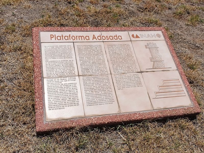
Las excavaciones realizadas entre 1917 y 1920, mostraron que en el edificio principal del conjunto de la Ciudadela existia una superposición de estructuras. Efectivamente, varias décadas después de su construcción, la fachada principal del Templo de la Serpiente Emplumada fue cubierta por la Plataforma Adosada y se mantuvo así hasta la caída de Teotihuacán.
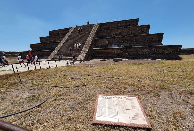
Esta plataforma es piramidal, de 50 m. de ancho en la base, y se compone de cuatro cuerpos escalonados, en talud y tablero, de estilo típicamente teotihuacano. En la fachada y orientada hacia el poniente, hay una escalinata de una sola rampa que conduce hacia la parte superior, donde se encontraba el templo. A diferencia del Templo de Quetzalcoatl, en la Plataforma Adosada la ornamentación se limitó a pinturas Imurales en los tableros, realizadas. sobre un fondo rojo, que se conservan parcialmente.
La construcción de esta plataforma sobre los frisos del Templo de la Serpiente Emplumada, se debió, probablemente, a cambios en los grupos gobernantes. Existen evidencias de que entre los años 340 y 400 d.C, se saquearon tanto el frente del edificio como su esquina sureste, desde donde se realizó un tunel hacia las tumbas ubicadas debajo del edificio. Otras exploraciones realizadas en diferentes partes de la ciudad han ofrecido pruebas adicionales de rupturas al interior de los grupos de poder en esa época.
In tlamachiltataquiliztli tlen mochihuaya ipan in 1917 ihuan 1920 xihuill, mixnexti mach in yolocaltepantli in tlen mochi caltepancetiliztli in altepetontli, in ipan monenepanohuayà ce qui tlachichihualiztli. Ihuan ohquion, zatepan cuac opanoque occequi xihuitl, yoloixpa in Quetzalcoatl Teocalli quixtlapachoque ica in Tlaltetzontli tlacuicuiliztli ihuan inin ohquion omocauh ihuan oàcic cuac opoliuh in Teotihuacan tlatlaca. Inin tlaltetzontli cateocalli, ihuan quipiya 50 m. tlalpatlahuac, ihuan quipiya nahui caltepantin tlen quipiyà temamatiati, ipantlen itoca talud ihuan tiablero, ihuan inin zan teotihuacan tlachihualiztli. Ihuan inin moxayacatia compic in canin icalaquian tonatiuh, ihuan zan onca ce temamatlatl ihuan zan quipiya ce tien itoca rampa tlen tlacpac tehuica, in canin catca in teocalli. Ihuan tien àmo quipiya in Quetzalcoatl Teocalli, in Tlaltetzontli Tlacuicuiliztli, in tlatlamachtli zan quipiya tlapaltepamitl ipan in tlen itoca tableros, tlen omochiuhque ipan tlalchichiltic, tlen zaye axan amo mochi onca. Inin tlachichihualiztli in tlen tlaltetzontli ipan in tlen itoca in frisos in Quetzalcoatl Teocalli, mate inin omochiuh tleca omopatlaque in tlanahuatique. Mochi onca occequi tlamachiliztli ipan xihuitl 340 ihuan 400 d.C., in tlen oquichtequilique ixpa in caltepantli ihuan in tlanacaztla huitztlampa-icalaquian tonatiuh, ipan in canin omochiuh ce tlacoyoctli tlen àci ompa mihcatlatoctli ic tlatzintla in caltecpantli. In occequi tlamachiltla- toquiliztli ipan in cècehcan in altepetl, cuali techihtitia in quenin omoxexelòque in tlatlaca cuac opanoc inon xihuitl.
Embedded Platform
The excavations carried out between 1917 and 1920 showed that indeed, there was a superposition of structures in the principal building of the Citadel group. Indeed, various decades after its constuction, the principal façade of the Temple of the Plumed Serpent was covered by the Embedded Platform and remained that way until the fall of Teotihucán. This platform is pyramidal, measuring 50 m. wide at the base, and is composed of four stepped bodies in “slope and panel" design typical of the Teotihucán style. There is a single flight of steps which leads to the upper part, where a temple was found on the west façade. As opposed to the Temple of Quetzalcoatl, the Embedded Platform is limited to mural paintings on the panels, done on a red background, which has been partially preserved.
The construction of this platform, which covers the friezes of the Temple of the Plumed Serpent, probably resulted from a change in the ruling groups. Evidence exists that both the front of the building and its southeast corner, from where a tunnel was built to the tombs located under the building, were looted between 340 and 400 A.D.
Erected by Instituto de Antropología e Historia (INAH).
Topics. This historical marker is listed in these topic lists: Anthropology & Archaeology • Architecture. A significant historical year for this entry is 1917.
Location. 19° 40.918′ N, 98° 50.819′ W. Marker is in Teotihuacán de Arista, Estado de Mexico (Mexico State), in Teotihuacán. Marker is on Calzada de los Muertos just east of Route 132, on the right when traveling north. Touch for map. Marker is in this post office area: Teotihuacán de Arista MEX 55825, Mexico. Touch for directions.
Other nearby markers. At least 8 other markers are within walking distance of this marker. Temple of the Plumed Serpent (within shouting distance of this marker); The Southern Building of Teotihuacan (within shouting distance of this marker); Southern Building (within shouting distance of this marker); La Ciudadela (about 150 meters away, measured in a direct line); Avenue of the Dead (about 210 meters away); Monolithic Sculpture of a Water-related Deity (approx. 0.3 kilometers away); Northwest San Juan River Complex (approx. half a kilometer away); Plaza C of the Avenue of the Dead Complex (approx. 0.6 kilometers away). Touch for a list and map of all markers in Teotihuacán de Arista.
Credits. This page was last revised on May 1, 2024. It was originally submitted on June 3, 2022, by J. Makali Bruton of Accra, Ghana. This page has been viewed 74 times since then and 11 times this year. Photos: 1, 2. submitted on June 3, 2022, by J. Makali Bruton of Accra, Ghana.

