Brea in Orange County, California — The American West (Pacific Coastal)
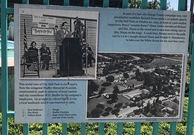
Richard Nixon in City Hall Park
This aerial view of City Hall Park is circa 1950's. Note the octagonal Shaffer Memorial Fountain, constructed in 1948 in memory of businessman and city councilman W.D. Shaffer by his company's employees. Lit at night by colored lights, it was a local landmark until it was removed in 1969.
Erected by Brea Historical Society.
Topics. This historical marker is listed in these topic lists: Government & Politics • Notable Places. A significant historical date for this entry is October 20, 1952.
Location. 33° 54.866′ N, 117° 54.146′ W. Marker is in Brea, California, in Orange County. Marker can be reached from Brea Boulevard south of Date Street, on the right when traveling south. Located in City Hall Park. Touch for map. Marker is at or near this postal address: 401 S Brea Blvd, Brea CA 92821, United States of America. Touch for directions.
Other nearby markers. At least 8 other markers are within walking distance of this marker. Many a Child (here, next to this marker); Brea Plunge (here, next to this marker); Ralph E. Barnes Bandstand (a few steps from this marker); Old City Hall (about 300 feet away, measured in a direct line); City Hall Park (about 300 feet away); Brea American Legion Building (about 400 feet away); Brea Veterans Memorial (about 400 feet away); The Humming Bird (approx. half a mile away). Touch for a list and map of all markers in Brea.
Credits. This page was last revised on April 2, 2024. It was originally submitted on June 11, 2022, by Adam Margolis of Mission Viejo, California. This page has been viewed 132 times since then and 28 times this year. Photos: 1, 2. submitted on June 11, 2022, by Adam Margolis of Mission Viejo, California. • Syd Whittle was the editor who published this page.

