Near Chidester in Ouachita County, Arkansas — The American South (West South Central)
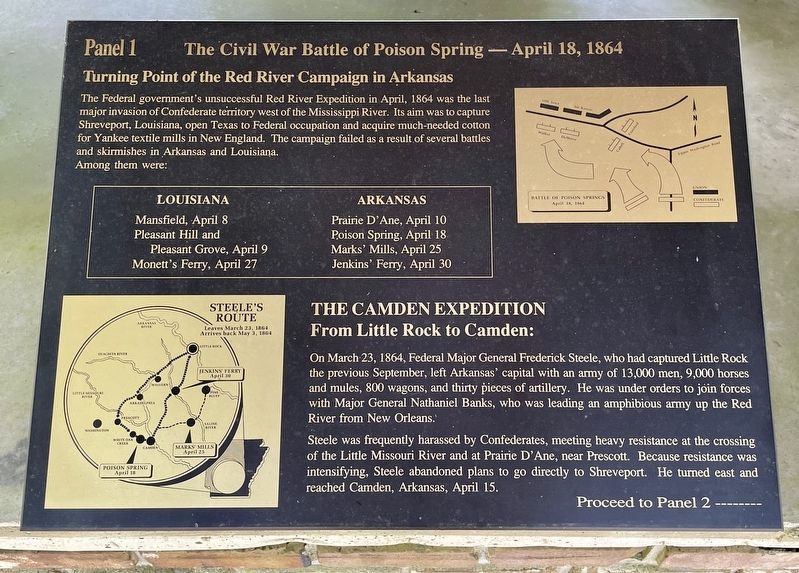
The Civil War Battle of Poison Spring - April 18, 1864
Turning Point of the Red River Campaign in Arkansas
— Panel 1 —
Inscription.
The Federal government's unsuccessful Red River Expedition in April, 1864 was the last major invasion of Confederate territory west of the Mississippi River. Its aim was to capture Shreveport, Louisiana, open Texas to Federal occupation and acquire much-needed cotton for Yankee textile mills in New England. The campaign failed as a result of several battles and skirmishes in Arkansas and Louisiana.
Among them were:
Louisiana
Mansfield, April 8
Pleasant Hill and
Pleasant Grove, April 9
Monett's Ferry, April 27
Arkansas
Prairie D' Ane, April 10
Poison Spring, April 18
Marks' Mills, April 25
Jenkins' Ferry, April 30
The Camden Expedition
From Little Rock to Camden:
On March 23, 1864, Federal Major General Frederick Steele, who had captured Little Rock the previous September, left Arkansas' capital with an army of 13,000 men, 9,000 horses and mules, 800 wagons, and thirty pieces of artillery. He was under orders to join forces with Major General Nathaniel Banks, who was leading an amphibious army up the Red River from New Orleans.
Steele was frequently harassed by Confederates, meeting heavy resistance at the crossing of the Little Missouri River and at Prairie D'Ane, near Prescott. Because resistance was intensifying, Steele abandoned plans to go directly to Shreveport. He turned east and reached Camden, Arkansas, April 15.
Proceed to Panel 2 -------
Topics and series. This historical marker is listed in this topic list: War, US Civil. In addition, it is included in the National Historic Landmarks series list. A significant historical date for this entry is March 23, 1864.
Location. 33° 38.333′ N, 93° 0.259′ W. Marker is near Chidester, Arkansas, in Ouachita County. Marker can be reached from Arkansas Route 76, 1.2 miles west of County Road 100, on the right when traveling west. Located in Poison Springs Battleground State Park. Touch for map. Marker is at or near this postal address: 665 Hwy 76, Chidester AR 71726, United States of America. Touch for directions.
Other nearby markers. At least 8 other markers are within walking distance of this marker. Order of Battle (here, next to this marker); Forage Party Routed! (here, next to this marker); The First Kansas (here, next to this marker); Federal Forage Party Departs Camden April 17, 1864 (here, next to this marker); Confederate and Federal Forces Engage (here, next to this marker); The Battle of Poison Springs. (a few steps from this marker); Ouachita County Poison Springs Battlefield (within shouting distance of this marker); Engagement at Poison Springs (within shouting distance of this marker). Touch for a list and map of all markers in Chidester.
Also see . . . Wikipedia article on the Poison Springs Battleground State Park
. A Part of the Camden Expedition Sites National Historic Landmark. (Submitted on June 30, 2022, by Mark Hilton of Montgomery, Alabama.)
Credits. This page was last revised on June 30, 2022. It was originally submitted on June 30, 2022, by Mark Hilton of Montgomery, Alabama. This page has been viewed 186 times since then and 35 times this year. Photos: 1, 2, 3. submitted on June 30, 2022, by Mark Hilton of Montgomery, Alabama.


