Sterling in Loudoun County, Virginia — The American South (Mid-Atlantic)
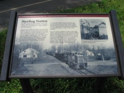
Sterling Station
Beginning in 1860, the station served local farmers. Trains carried grain, produce, and dairy products to eastern markets, returning with merchandise and mail. Passengers rode to school, to shop and visit. Many commuted to jobs in Washington, D.C. In the 1890s, after financier J.P. Morgan bought the line, he supposedly gave Sterling its name because of his banking interests.
A small close-knit community grew up around the railroad station. Airy wooden homes lined the north side of the tracks. On the south side were businesses including a mercantile store, a mill, and a meat market.
One two-story residence, built in the early 1850s, achieved fame as the Summer White House. President James Buchanan (served 1857-61) brought his family here to escape the heat of Washington in the summers of 1859 and 1860. The house operated for many years afterward as a hotel and an antique shop. It was demolished in the 1980s. Little remains of Old Sterling.
Erected by The Washington & Old Dominion Railroad Regional Park - Northern Virginia Regional Park Authority.
Topics and series. This historical marker is listed in this topic list: Railroads & Streetcars . In addition, it is included in the Former U.S. Presidents: #15 James Buchanan, the NOVA Parks, and the Washington and Old Dominion (W&OD) Railroad series lists. A significant historical year for this entry is 1967.
Location. 39° 0.376′ N, 77° 25.709′ W. Marker is in Sterling, Virginia, in Loudoun County. Marker is at the intersection of Ruritan Circle and Ruritan Road, on the right when traveling west on Ruritan Circle. Located along the Washington & Old Dominion Railroad Trail Park, a few yards from the intersection. Touch for map. Marker is in this post office area: Sterling VA 20164, United States of America. Touch for directions.
Other nearby markers. At least 8 other markers are within 2 miles of this marker, measured as the crow flies. Rails to Dulles Airport (approx. 0.9 miles away); Vestal's Gap Road (approx. 1.4 miles away); a different marker also named Vestal's Gap Road (approx. 1.4 miles away); George Washington (approx. 1˝ miles away); a different marker also named The Vestal's Gap Road (approx. 1˝ miles away); a different marker also named George Washington (approx. 1˝ miles away); The Braddock Campaign (approx. 1˝ miles away); Lanesville Families (approx. 1˝ miles away). Touch for a list and map of all markers in Sterling.
More about this marker. The background of the marker is a photograph of a train in Sterling in 1967; the original station stood behind the Sterling Supply store. An inset photo on the upper right showing Bill Bowie unloads a mailbag at the Sterling passenger shelter.
Also see . . .
1. Sterling Park Began as a Rail Station. An article detailing Sterling's past. (Submitted on June 21, 2009, by Craig Swain of Leesburg, Virginia.)
2. Sterling Station. 1927 photo of the station and links to rail yard diagrams. (Submitted on June 21, 2009, by Craig Swain of Leesburg, Virginia.)
Credits. This page was last revised on June 16, 2016. It was originally submitted on June 21, 2009, by Craig Swain of Leesburg, Virginia. This page has been viewed 3,024 times since then and 79 times this year. Photos: 1, 2, 3, 4. submitted on June 21, 2009, by Craig Swain of Leesburg, Virginia.


