Near Needles in San Bernardino County, California — The American West (Pacific Coastal)
Historic Route 66
in the Heart of Mojave
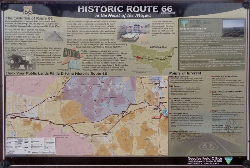
The Evolution of Route 66
Commissioned in 1926 and dubbed the "Mother Road," Route 66 linked Chicago and Los Angeles - a highway of hope that led thousands of people to a new life in the West.
In 1926, less than half of Route 66 was paved, none of which was in the California desert. It wasn't until 1938 that the entire route was paved, making it the first all-paved highway in the country. At that time, it took travelers about 5 days to travel from Chicago to Los Angeles.
Route 66 served as a major thoroughfare for Dust Bowl migrants in the 1930s. Thousands of people from the South and Midwest traveled the "Mother Road" to California in search of a better life. The increased traffic on Route 66 during the Great Depression kept many small highway towns alive.
Most of the towns along Route 66 started out as railroad water stops and soon grew to accommodate the many travelers on the popular route. At one time, roadside communities in the desert had one-room school houses, train depots, cafes, motor courts (motels), gas stations, and campgrounds. Today, very few of those services remain.
Route 66 became a very popular vacation route after World War II, both for its destinations and for the sights along the way. In 1946, it was popularized even further when Bobby Troup wrote the song "Get Your Kicks on Route 66."
Traffic congestion, accidents, and highway deterioration increased with the popularity of Route 66, and the nation realized the need for a modernized transportation network. In 1972, the desert portion of Route 66 was officially bypassed by Interstate 40, and the old two-lane road was decommissioned and turned over to San Bernardino County. In 1984, the last piece of Route 66, near Williams, Arizona, was bypassed by Interstate 40.
Points of Interest
1 - Trails Arch Bridge
This was the original path people used to cross the Colorado River on Route 66. Now the bridge carries a natural gas pipeline over the river.
2 - El Garces
Located in downtown Needles, this building served as a hotel and restaurant for railroad passengers and travelers on Route 66.
3 - The Goffs Schoolhouse Museum and Cultural Center
Operated by the Mojave Desert Heritage and Cultural Association, this is a great place to learn about life in the Mojave Desert in the early 1900s. Admission is free, but hours vary.
4 - The Mojave Road
Once known as the Mojave Trail, this was one of the first trade routes used by indigenous people who lived throughout the Mojave Desert. With a four-wheel-drive vehicle, it can still be traveled today.
5 - Mojave National Preserve
This 1.6 million-acre preserve is managed by the National Park Service. Visitors can get information at the Hole-in-the-Wall and Kelso Visitor Centers.
6 - Bonanza Spring Watchable Wildlife Area
Springs are some of the best places to view wildlife in the desert. A four-wheel-drive vehicle is recommended to visit this site.
7 - Amboy Crater National Natural Landmark
This is an excellent example of a very symmetrical volcanic cinder cone. The entrance road to the parking area is accessible to all vehicle types, and there is a 1.5-mile hiking trail that leads to the top of the crater.
8 - Pisgah Center
With a variety of lava types and intact lava tubes, this is a unique destination for geology enthusiasts. Only part of the lava flow is on public land.
9 - The Bagdad Café
Your drive along Route 66 in the Mojave Desert is not complete without a stop at the famous Bagdad Café.
(photo captions:)
·Today, the pioneering spirit of Route 66 lives on through music, film, and preservation work from clubs, associations, and interested individuals like you!
·Several sections of Route 66 have been preserved, however it is no longer possible to drive the original Route from Chicago to Los Angeles in its entirety.
National Conservation Lands
Along Route 66
The Bureau of Land Management's National Conservation Lands contain some of the West's most spectacular landscapes. These lands are part of an active, vibrant landscape where people live, work, and play. They offer exceptional opportunities for recreation, solitude, wildlife viewing, exploring history, scientific research, and a wide range of traditional uses.
Within the National Conservation Lands, wilderness areas are designated to preserve and protect lands that are largely undeveloped, natural and unconstrained by human activity. These areas retrain a primeval character, without permanent improvements, and have been affected primarily by the forces of nature. Wilderness areas provide outstanding opportunities for solitude and unconfined recreation, such as hiking, camping, canoeing, and horseback riding.
Also within the National Conservation Lands is the World War II Desert Training Center (California-Arizona Maneuver Area). During World War II, this area of the Mojave Desert played host to the largest simulated military training ground in the history of military maneuvers. Divisional camps were set up throughout southern California, Arizona, and Nevada.
Erected by Bureau of Land Management.
Topics and series. This historical marker is listed in these topic lists: Industry & Commerce • Roads & Vehicles. In addition, it is included in the U.S. Route 66 series list. A significant historical year for this entry is 1926.
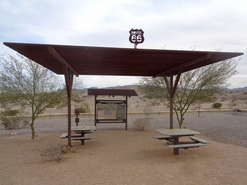
Location. 34° 45.655′ N, 114° 34.633′ W. Marker is near Needles, California, in San Bernardino County. Marker is on 5 Mile Road west of Interstate 40, on the left when traveling west. Located at Historic Route 66 California Gateway picnic area. Touch for map. Marker is at or near this postal address: National Old Trails Rd, Needles CA 92363, United States of America. Touch for directions.
Other nearby markers. At least 4 other markers are within 7 miles of this marker, measured as the crow flies. Citizens of Needles (approx. 5.7 miles away); Needles El Garces Train Station, Needles, California (approx. 5.7 miles away); Old Cantilever Train Signal (approx. 5.7 miles away); National Old Trails (approx. 6½ miles away).
Credits. This page was last revised on January 5, 2024. It was originally submitted on July 10, 2022, by Jason Voigt of Glen Carbon, Illinois. This page has been viewed 219 times since then and 60 times this year. Photos: 1, 2, 3. submitted on July 11, 2022, by Jason Voigt of Glen Carbon, Illinois.


