Hillsville in Lawrence County, Pennsylvania — The American Northeast (Mid-Atlantic)
Quaker Falls
Pre-contact
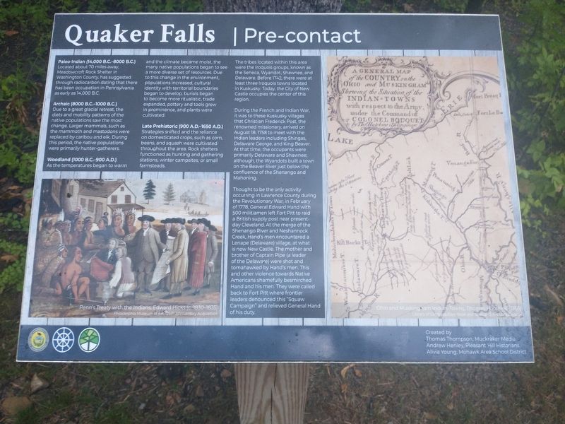
Located about 70 miles away, Meadowcroft Rock Shelter in Washington County, has suggested through radiocarbon dating that there has been occupation in Pennsylvania as early as 14,000 B.C.
Archaic (8000 B.C.-1000 B.C.)
Due to a great glacial retreat, the diets and mobility patterns of the native populations saw the most change. Larger mammals, such as the mammoth and mastodons were replaced by caribou and elk. During this period, the native populations were primarily hunter-gatherers.
Woodland (1000 B.C.-900 A.D.)
As the temperatures began to warm and the climate became moist, the many native populations began to see a more diverse set of resources. Due to this change in the environment, populations increased, cultural identity with territorial boundaries began to develop, burials began to become more rítualístic, trade expanded, pottery and tools grew in prominence, and plants were cultivated.
Late Prehistoric (900 A.D.-1650 A.D.)
Strategies shifted and the reliance on domesticated crops, such as corn, beans, and squash were cultivated throughout the area. Rock shelters functioned as hunting and gathering stations, winter campsites, or small farmsteads.
The tribes located within this area were the Iroquois groups, known as the Seneca, Wyandot, Shawnee, and Delaware. Before 1742, there were at least three Iroquois towns located in Kuskusky. Today, the City of New Castle occupies the center of this region.
During the French and Indian War, it was to these Kuskusky villages that Christian Frederick Post, the renowned missionary, arrived on August 18, 1758 to meet with the Indian leaders including Shingas, Delaware George, and King Beaver, At that time, the occupants were primarily Delaware and Shawnee, although, the Wyandots built a town on the Beaver River just below the confluence of the Shenango and Mahoning.
Thought to be the only activity occurring in Lawrence County during the Revolutionary War, in February of 1778, General Edward Hand with 500 mílítíamen left Fort Pitt to raid a British supply post near present- day Cleveland. At the merge of the Shenango River and Neshannock Creek, Hand's men encountered a Lenape (Delaware) village, at what is now New Castle. The mother and brother of Captain Pipe (a leader of the Delaware) were shot and tomahawked by Hand's men. This and other violence towards Native Americans shamefully besmirched Hand and his men. They were called back to Fort Pitt where frontier leaders denounced this "Squaw Campaign” and relieved General Hand of his duty.
Topics. This historical marker is listed in this topic list: Native Americans. A significant historical month for this entry is February 1778.
Location. 41° 1.305′ N, 80° 30.625′ W. Marker is in Hillsville, Pennsylvania, in Lawrence County. Marker is on W. State Street, on the right when traveling west. Touch for map. Marker is in this post office area: Hillsville PA 16132, United States of America. Touch for directions.
Other nearby markers. At least 8 other markers are within 2 miles of this marker, measured as the crow flies. A different marker also named Quaker Falls (within shouting distance of this marker); a different marker also named Quaker Falls (within shouting distance of this marker); Burton Powder Company (within shouting distance of this marker); Mahoning Township Veterans Memorial (approx. 1.4 miles away); Lowellville Veterans Park (approx. 1.6 miles away in Ohio); Lowellville Veterans Memorial (approx. 1.6 miles away in Ohio); The Mahoning River on Display (approx. 1.7 miles away in Ohio); Lowellville: The Valley's Flour and Grain Center (approx. 1.8 miles away in Ohio). Touch for a list and map of all markers in Hillsville.
Credits. This page was last revised on July 16, 2022. It was originally submitted on July 15, 2022, by Craig Doda of Napoleon, Ohio. This page has been viewed 110 times since then and 42 times this year. Photos: 1. submitted on July 15, 2022, by Craig Doda of Napoleon, Ohio. 2, 3, 4. submitted on July 16, 2022, by Craig Doda of Napoleon, Ohio. • Bill Pfingsten was the editor who published this page.


