Naarden in Gooise Meren, North Holland, Netherlands — Northwestern Europe
Bastion Turfpoort
Photographed by Andrew Ruppenstein, July 22, 2022
1. Bastion Turfpoort Marker

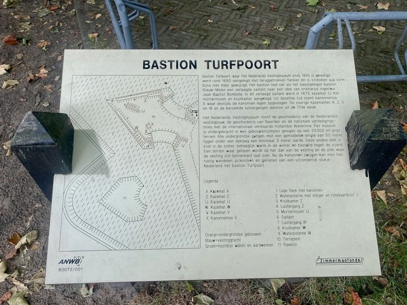
Het Nederlandse Vestingmuseum toont de geschiedenis van de Nederlandse vestingbouw, de geschiedenis van Naarden en de nationale verdedigings- linies met de internationaal vermaarde Hollandse Waterlinie. Het museum is ondergebracht in een gebouwencomplex gelegen op een 20.000 m² groot terrein. Alle ondergrondse gangen met een gemiddelde lengte van 50 meter, liggen onder een deklaag van minimaal 3 meter aarde. Deze unieke plek is koel in de zomer, behaaglijk warm in de winter en bestand tegen de vijand. Een terrein waar
this page online
Bastion Turfpoort, where the Netherlands Fortress Museum has been located since 1955, was built around 1680 with recessed flanks and has hardly changed in shape since then. Just like the adjacent Nieuw-Molen bastion, the bastion had a lowered salient according to the plan of engineer Jean Baptist Bombelle. Casemate IJ with mortar niches and a powder room was constructed in 1875 in this lowered sailient. Cannon depot X dates from the same time, where the cannons were stored at the time. The other casemates A, Z, V and W and the famous "listening" passages date from the 17th century.
The Dutch Fortress Museum displays the history of Dutch fortification, the history of Naarden and the national defense lines of the internationally renowned Dutch Waterline. The museum is housed in a building complex located on a 20,000 m² site. All underground passages with an average length

Photographed by Andrew Ruppenstein, July 22, 2022
2. Bastion Turfpoort Marker - wide view
Erected by The ANWB.
Topics. This historical marker is listed in this topic list: Forts and Castles.
Location. 52° 17.616′ N, 5° 9.602′ E. Marker is in Naarden, Noord-Holland (North Holland), in Gooise Meren. It is at the intersection of Westwalstraat and Sint Annastraat, on the right when traveling south on Westwalstraat. Touch for map. Marker is in this post office area: Naarden, Noord-Holland 1411 PB, Netherlands. Touch for directions.

Regionally, it is in Europe, the European Union, Atlantic Europe, the Benelux Low Countries, the Schengen Area, Western Europe, and the Western World. Historically, it finds itself in what was once the Holy Roman
Photographed by Foto Technische Dienst Luchtvaartafdeeling (via Wikimedia Commons), circa 1930
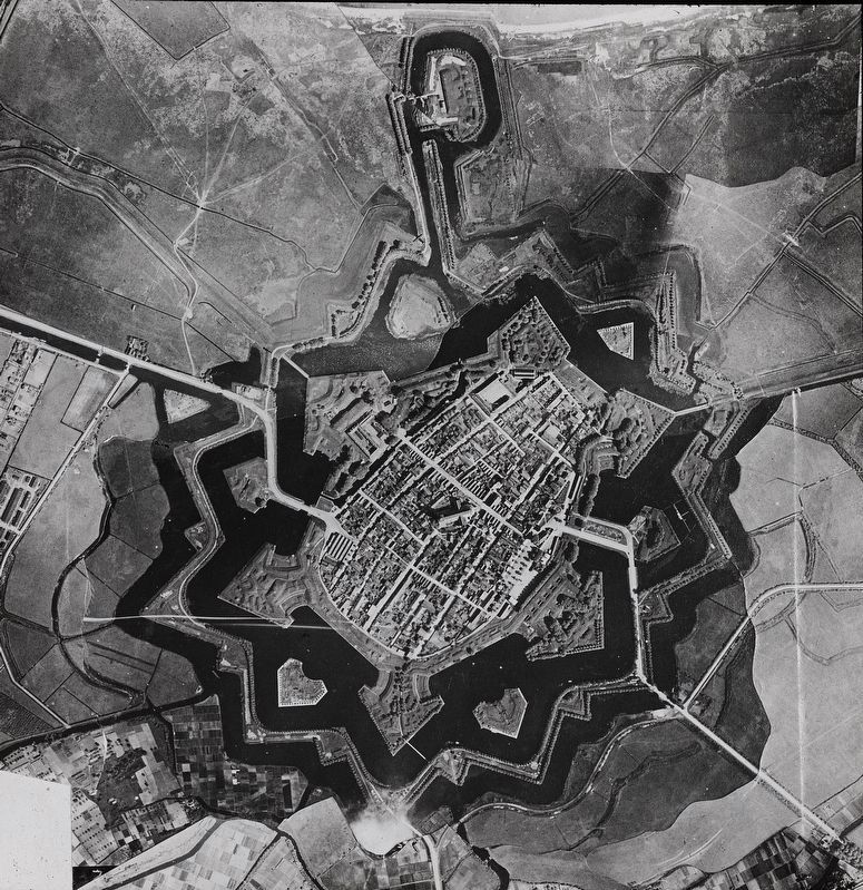
3. Aerial photograph of Naarden, The Netherlands
The Turfpoort Bastion is the southernmost of the bastions visible here (the one between the two islands).
Full photo credit: Nederlands Instituut voor Militaire Historie/Wikimedia Commons under CC license 4.0.
Other nearby markers. At least 8 other markers are within walking distance of this marker: Lange Bedekte Weg Naarden (about 150 meters away, measured in a direct line); Het Spaanse Huis / The Spanish House (about 210 meters away); Naarden; Erfgooiersroute (approx. 0.3 kilometers away); De Promerskazerne / Promers Barracks (approx. 0.3 kilometers away); Oude Stadehuis / Old City Hall - Marktstraat 22 Naarden (approx. 0.3 kilometers away); Stadhuis / City Hall (approx. 0.3 kilometers away); Replica van Stadspomp / City Water Pump Replica (approx. 0.3 kilometers away); Kogel / Cannonball (approx. 0.4 kilometers away). Touch for a list and map of all markers in Naarden.
Also see . . .
1. Nederlands Vesting Museum. Website homepage:
Excerpt: "Naarden, situated on a sandy ridge on the shore of the former Zuiderzee, used to be the only access road from the east to the County of Holland and the merchant city of Amsterdam. Due to this military-strategic location, Naarden developed into one of the most important fortress towns of the Netherlands through the centuries, and was often fought over...."(Submitted on August 3, 2022.)
2. Dutch Fortress Museum. Wikipedia entry:
Excerpt: "The Dutch Fortress Museum (Nederlands Vestingmuseum) is located in the city of Naarden, The Netherlands. The Museum was established by volunteers in 1955 at bastion Turfpoort, one of six bastions that give the walled city its distinctive star shape. (During World War II, allied bombers returning to Great Britain from bombing missions used it as a marker.) The fortifications themselves, including the bastions, date from the period 1575-1585, when King Philip II of Spain ordered them to be constructed....The museum includes exhibits on the history of fortification, garrison life, the Dutch Water Line, and the history of the city of Naarden-Vesting...."(Submitted on August 3, 2022.)
Credits. This page was last revised on February 27, 2025. It was originally submitted on August 3, 2022, by Andrew Ruppenstein of Lamorinda, California. This page has been viewed 208 times since then and 30 times this year. Photos: 1, 2, 3. submitted on August 3, 2022, by Andrew Ruppenstein of Lamorinda, California.
