Weesp in Amsterdam, North Holland, Netherlands — Northwestern Europe
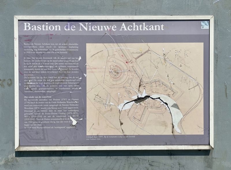
Bastion de Nieuwe Achtkant
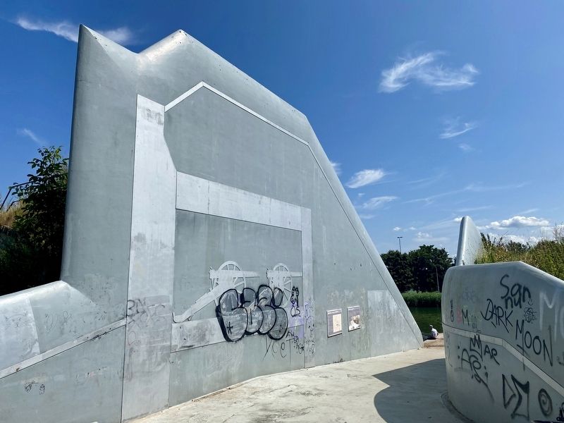
Je staat hier in een doorsnede van de aarden wal van het bastion. De onderste lijn op de wand achter je geeft aan hoe hoog de wal in de 17e eeuw was. Die eerste wal bestond uit een talud met 'borstwaring': de soldaten, zogenaamde musketiers, waren tot aan hun borst beschermd. Ze konden over de wal heen kijken en schieten. Hier en daar stonden kanonnen.
De bovenste lijn op deze wand laat de omvang van de wal, zien eind 19e eeuw. De wal was aanzienlijk opgehoogd en verbreed omdat kort daarvoor de exploderende brisantgranaat uitgevonden was. Om de soldaten ook van opzij tegen rondvliegende granaatscherven te beschermen werden 'traversen', dwarswallen, aangelegd.
Het einde van de waterlinie
Bij succesvolle aanvallen van Pruisen (1787) en Fransen (1794) bleek de zwakte van de Oude Hollandse Waterlinie. Er werd een verbeterde versie aangelegd: de Nieuwe Hollandie Waterlinie (1870), waarin ook Weesp weer werd opgenomen. Driemaal is de nieuwe linie in staat van verdediging gebracht: tijdens de Frans-Duitse Oorlog (1870-1871), WO I (1914-1918) en aan de vooravond van WO II (1939-1945). Toen de Duitse invasiemacht er in de meidagen van 1940 gewoon overheen vloog, was dat voor de waterlinie begin van het einde.
In 1959 werd Weesp officieel als "vestingwerk” opgeheven.
Through erosion and spontaneous plant growth, Bastion de Nieuwe Achtkant had become, like other local fortifications, barely recognizable. After a partial reconstruction in 2010, the Bastion was restored to its appearance at the end of the 19th century.
You are standing here in a cross-section of the earthen wall of the bastion. The bottom line on the wall behind you indicates how high the rampart was in the 17th century. That first wall consisted of a slope with a 'breast guard': the soldiers, so-called musketeers, were protected up to their chests. They could look over the shore and shoot. Here and there stood guns.
The top line on this wall shows the extent of the rampart, see late 19th century. The rampart had been raised considerably and widened because shortly before the exploding high-explosive grenades was invented. In order to protect the soldiers from lateral-flying
shrapnel, tranverse walls were constructed.
The End of the Waterline
Successful attacks by Prussia (1787) and French (1794) demonstrated the weakness of the Old Dutch Waterline. Hence an improved version was built: the Nieuwe Hollandie Waterline (1870), which again also included Weesp. Three times the new line was brought into a state of defence readiness: during the Franco-Prussian War (1870-1871), WW I (1914-1918), and on the eve of WWII (1939-1945). When the German invasion force simply flew over the defenses in the May days of 1940, that was the beginning of the end for the Waterline.
Erected 2011.
Topics. This historical marker is listed in these topic lists: Forts and Castles • Wars, Non-US.
Location. 52° 18.426′ N, 5° 2.89′ E. Marker is in Weesp, Noord-Holland (North Holland), in Amsterdam. Marker can be reached from Ossenmarkt. Touch for map. Marker is in this post office area: Weesp, Noord-Holland 1381 HH, Netherlands. Touch for directions.
Other nearby markers. At least 8 other markers are within 6 kilometers of this marker, measured as the crow flies. Soldaat en Geschut / Soldiers and Artillery (here, next to this marker); Fort aan de Ossenmarkt (about 150 meters away, measured in a direct line); Stadhuis / City Hall (approx. 0.4 kilometers away); Weesp Jewish Deportation Memorial (approx. half a kilometer away); Annie Romein (approx. 5.6 kilometers away); Harriët Freezer (approx. 5.6 kilometers away); Nana Yaa Adu-Ampoma (approx. 5.7 kilometers away); Efua Sutherland (approx. 5.7 kilometers away). Touch for a list and map of all markers in Weesp.
More about this marker. To reach this marker, start at the parking lot at Ossenmarkt and simply follow the trail for about 3 minutes. The location does have a nice view of the Vecht River and there are even a couple of windmills in the distance.
Credits. This page was last revised on December 31, 2023. It was originally submitted on August 17, 2022, by Andrew Ruppenstein of Lamorinda, California. This page has been viewed 86 times since then and 13 times this year. Photos: 1, 2. submitted on August 17, 2022, by Andrew Ruppenstein of Lamorinda, California.

