Near Sandstone in Pine County, Minnesota — The American Midwest (Upper Plains)
Sawing Slabs
Discover the Banning Quarry
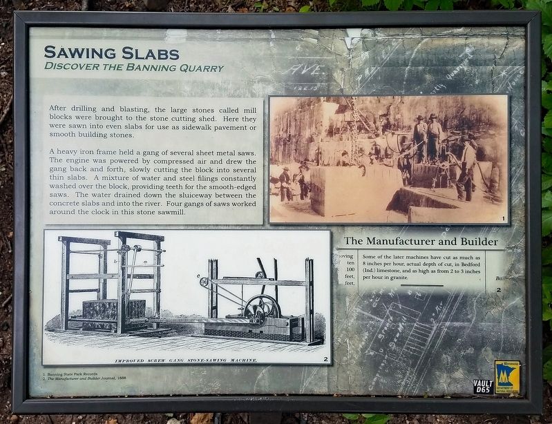
After drilling and blasting, the large stones called mill blocks were brought to the stone cutting shed. Here they were sawn into even slabs for use as sidewalk pavement or smooth building stones.
A heavy iron frame held a gang of several sheet metal saws. The engine was powered by compressed air and drew the gang back and forth, slowly cutting the block into several thin slabs. A mixture of water and steel filing constantly washed over the block, providing teeth for the smooth-edged saws. The water drained down the sluiceway between the concrete slabs and into the river. Four gangs of saws worked around the clock in this stone sawmill.
The Manufacturer and Builder
Some of the later machines have cut as much as 8 inches per hour, actual depth of cut, in Bedford (Ind.) limestone, and as high as from 2 to 3 inches per hour in granite.
Erected by Minnesota Department of Natural Resources.
Topics. This historical marker is listed in this topic list: Industry & Commerce. A significant historical year for this entry is 1896.
Location. 46° 9.477′ N, 92° 50.906′ W. Marker is near Sandstone, Minnesota, in Pine County. The marker is in Banning State Park (vehicle permit required). The marker is on the Quarry Loop Trail. Touch for map . Marker is at or near this postal address: 61101 Banning Park Road, Sandstone MN 55072, United States of America. Touch for directions.
Other nearby markers. At least 8 other markers are within 11 miles of this marker, measured as the crow flies. Forming Blocks (about 700 feet away, measured in a direct line); Power (approx. 0.2 miles away); Crushing Stone (approx. 0.2 miles away); A Railroad Industry (approx. ¼ mile away); Sandstone Area Veterans Memorial (approx. 2 miles away); Lumbering in Minnesota (approx. 3.7 miles away); The Hinckley Fire (approx. 10½ miles away); The Great Hinckley Fire (approx. 10.8 miles away). Touch for a list and map of all markers in Sandstone.
Credits. This page was last revised on September 6, 2022. It was originally submitted on August 26, 2022, by McGhiever of Minneapolis, Minnesota. This page has been viewed 60 times since then and 6 times this year. Photos: 1, 2, 3. submitted on August 26, 2022, by McGhiever of Minneapolis, Minnesota. • J. Makali Bruton was the editor who published this page.


