Thompson's Station in Williamson County, Tennessee — The American South (East South Central)
Slavery at Thompson's Station
Thompson's Station, Tennessee
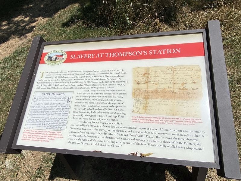
At that time the largest slave holders around Thompson's Station included: Samuel A. Pointer (40), Solomon Oden (33), Gabriel Buford (32), Samuel Fleming, Sr. (30), Thomas Boxley (23), Bird Fitzgerald (22), and J.S. Fitzgerald (19). With his 40 slaves, Pointer worked 200 acres of improved land, valued at $94,000, which produced 12,000 bushels of wheat, 6,250 bushels of com, and 65,000 pounds of tobacco.
Most Tennesseans who owned slaves owned five or less. But no matter the number owned, planters and farmers depended on their slaves to clear land, construct fences and buildings, and cultivate crops for market and home consumption. The expertise of skilled slaves-blacksmiths, masons, and carpenters--was especially valuable and could be hired out. Slaves toiled because they had to; they feared the whip, losing their family or being sold to Lower Mississippi Valley plantations where the mortality rate was higher.
Precilla Gray, born in Virginia around 1830 and enslaved by the Holland and Pointer families, remembered life as part of a larger African American slave community. She recalled barn dances, her marriage on the plantation, and attending church, but never went to school a day in her life. She remembered the song, "On Jordan's Bank I Stand and Cast a Wistful Eye...". The first work she remembers was making clothes for "everyone on the plantation" with a loom and working in the tobacco fields. With the Pointers, she worked in the fields until she was called to help with the mistress' children. She also vividly recalled being whipped and admitted that "I try not to think about the old times."
Topics. This historical marker is listed in these topic lists: African Americans • Agriculture.
Location. 35° 48.391′ N, 86° 54.588′ W. Marker is in Thompson's Station, Tennessee, in Williamson County. Marker can be reached from Depot Trail. Located within Preservation Park. Touch for map. Marker is at or near this postal address: 1600 Depot Trl, Thompsons Station TN 37179, United States of America. Touch for directions.
Other nearby markers. At least 8 other markers are within walking distance of this marker. Battle of Thompson's Station (about 700 feet away, measured in a direct line); Early Settlers (about 700 feet away); War and Occupation (approx. 0.2 miles away); Rebuilding the Countryside (approx. ¼ mile away); Building a Railroad Town, 1855-1993 (approx. ¼ mile away); A Deep Past, Rich Land (approx. ¼ mile away); Thompson's Station (approx. 0.4 miles away); Thompson's Station Train Depot (approx. 0.4 miles away). Touch for a list and map of all markers in Thompson's Station.
Credits. This page was last revised on October 23, 2022. It was originally submitted on September 4, 2022, by Darren Jefferson Clay of Duluth, Georgia. This page has been viewed 277 times since then and 56 times this year. Photos: 1. submitted on September 5, 2022, by Darren Jefferson Clay of Duluth, Georgia. 2. submitted on October 23, 2022, by Bradley Owen of Morgantown, West Virginia. • Mark Hilton was the editor who published this page.

