Granville in Licking County, Ohio — The American Midwest (Great Lakes)
Granville's Broadway
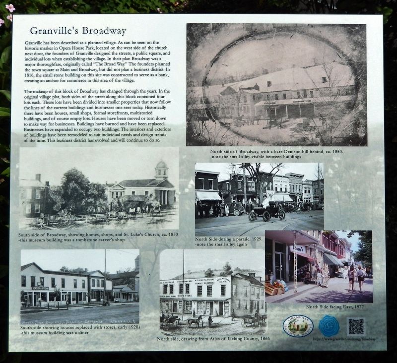
Granville has been described as a planned village. As can be seen on the historic marker in Opera House Park, located on the west side of the church next door, the founders of Granville designed the streets, a public square, and individual lots when establishing the village. In their plan Broadway was a major thoroughfare, originally called "The Broad Way." The founders planned the town square at Main and Broadway, but did not plan a business district. In 1816, the small stone building on this site was constructed to serve as a bank, creating an anchor for commerce in this area of the village.
The makeup of this block of Broadway has changed through the years. In the original village plat, both sides of the street along this block contained four lots each. These lots have been divided into smaller properties that now follow the lines of the current buildings and businesses one sees today. Historically there have been houses, small shops, formal storefronts, multistoried buildings, and of course empty lots. Houses have been moved or torn down to make way for businesses. Buildings have burned and have been replaced. Businesses have expanded to occupy two buildings. The interiors and exteriors of buildings have been remodeled to suit individual needs and design trends of the time. This business district has evolved and will continue to do so.
Erected 2022 by Granville Historical Society; and Granville Community Foundation.
Topics. This historical marker is listed in these topic lists: Architecture • Industry & Commerce • Roads & Vehicles • Settlements & Settlers. A significant historical year for this entry is 1816.
Location. 40° 4.063′ N, 82° 31.167′ W. Marker is in Granville, Ohio, in Licking County. Marker is at the intersection of East Broadway (Ohio Route 661) and Linden Place, on the right when traveling east on East Broadway. Marker is located in the garden courtyard directly in front of the Granville Historical Society Museum. Touch for map. Marker is at or near this postal address: 115 East Broadway, Granville OH 43023, United States of America. Touch for directions.
Other nearby markers. At least 8 other markers are within walking distance of this marker. Granville's Earliest Residents (here, next to this marker); Bank of the Alexandrian Society (here, next to this marker); Granville's Welsh Hills (a few steps from this marker); St. Luke's Episcopal Church (a few steps from this marker); Founding of Granville, The Licking Company / The Granville Site, "The most eligible part" (within shouting distance of this marker); Granville Opera House (within shouting distance of this marker); Bolen Memorial Park
(within shouting distance of this marker); The First Presbyterian Church of Granville (about 400 feet away, measured in a direct line). Touch for a list and map of all markers in Granville.
Related markers. Click here for a list of markers that are related to this marker.
Also see . . .
1. Granville History.
Unlike many settlements in the early 1800s, Granville was a planned community, founded in 1805 by people from the town of Granville, Massachusetts. These New Englanders faced an economic crisis, since their population was booming but the soil in their area was exhausted. They looked west to the then-new state of Ohio for their prosperity. Ohio may have still been the middle of nowhere, but the newcomers had planned out the town in advance and set to work realizing that vision. In contrast to most Ohio settlements, then, Granville benefited from being planned by close-knit Puritans who had a very specific vision of what constitutes a harmonious and livable community.(Submitted on September 21, 2022, by Cosmos Mariner of Cape Canaveral, Florida.)
2. Establishment and Settlement of Granville.
Granville was planned to closely resemble a "New England town" set down in the middle of Ohio. The plan began with two main and wide thoroughfares that intersected at the town square with churches on its corners. The plat continued with 24 blocks of 288 rectangular lots on the original plateau situated a safe 70 feet above the Raccoon Creek floodplain to the south. Nestled there between the three hills (Sugar Loaf rising 55 feet above the plateau on the west; College Hill at 135 feet high to the north; and Mt. Parnassus at 105 feet high on the east); these New Englanders constructed the main thoroughfare streets called Broad Way, Water and Bowery (now West and East College), as well as Fair and Equality (now West and East Elm).(Submitted on September 21, 2022, by Cosmos Mariner of Cape Canaveral, Florida.)
3. Granville museum takes village’s history outdoors.
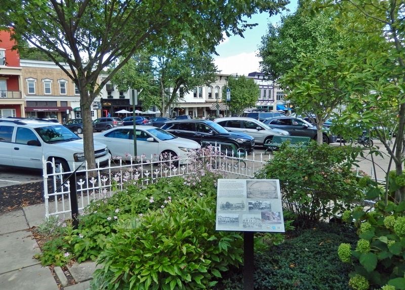
The “Granville’s Broadway” panel includes photos of the north side of the East Broadway business district. Since the museum is on the south side, the panel is situated so that viewers can look up from the historic photos and compare them to what the business district looks like today. Most intriguing is the Daguerreotype photo of the north side of Broadway downtown taken in approximately 1850. A 1929 photo of the same block is also included. There are also photos of the less-photographed south side of Broadway from the St. Luke’s Church building on the right, going east toward South Prospect Street. The buildings east from the bank building were destroyed in a fire in 1927.(Submitted on September 21, 2022, by Cosmos Mariner of Cape Canaveral, Florida.)
Credits. This page was last revised on October 4, 2022. It was originally submitted on September 21, 2022, by Cosmos Mariner of Cape Canaveral, Florida. This page has been viewed 107 times since then and 15 times this year. Photos: 1, 2. submitted on September 21, 2022, by Cosmos Mariner of Cape Canaveral, Florida.

