Spring Hill in Maury County, Tennessee — The American South (East South Central)
Federal Defense of Spring Hill
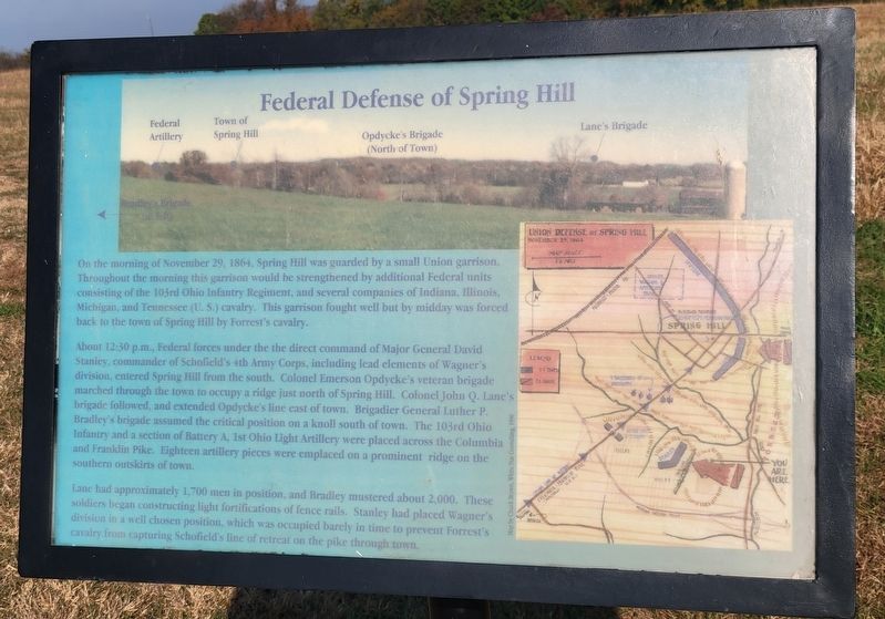
On the morning of November 29, 1864, Spring Hill was guarded by a small Union garrison. Throughout the morning this garrison would be strengthened by additional Federal units consisting of the 103rd Ohio Infantry Regiment, and several companies of Indiana, Illinois, Michigan, and Tennessee (U.S.) cavalry. This garrison fought well but by midday was forced back to the town of Spring Hill by Forrest's cavalry.
About 12:30 p.m., Federal forces under the the direct command of Major General David Stanley, commander of Schofield's 4th Army Corps, including lead elements of Wagner's division, entered Spring Hill from the south. Colonel Emerson Opdycke's veteran brigade marched through the town to occupy a ridge just north of Spring Hill. Colonel John Q. Lane's brigade followed, and extended Opdycke's line east of town. Brigadier General Luther P. Bradley's brigade assumed the critical position on a knoll south of town. The 103rd Ohio Infantry and a section of Battery A, 1st Ohio Light Artillery were placed across the Columbia and Franklin Pike. Eighteen artillery pieces were emplaced on a prominent ridge on the southern outskirts of town.
Lane had approximately 1,700 men in position, and Bradley mustered about 2,000. These soldiers began constructing light fortifications of fence rails. Stanley had placed Wagner's division in a well chosen position, which was occupied barely in time to prevent Forrest's cavalry from capturing Schofield's line of retreat on the pike through town.
Topics. This historical marker is listed in this topic list: War, US Civil. A significant historical date for this entry is November 29, 1864.
Location. 35° 44.303′ N, 86° 55.675′ W. Marker is in Spring Hill, Tennessee, in Maury County. Marker can be reached from the intersection of Kedron Road and Reserve Boulevard, on the right when traveling south. Located on the Spring Hill Battlefield hiking trail. Touch for map. Marker is at or near this postal address: 3525 Kedron Rd, Spring Hill TN 37174, United States of America. Touch for directions.
Other nearby markers. At least 8 other markers are within walking distance of this marker. Confederate Deployment (about 400 feet away, measured in a direct line); Cleburne's Attack (about 500 feet away); Forrest's 3:00 p.m. Cavalry Attack (approx. 0.2 miles away); Cleburne's Pursuit (approx. 0.2 miles away); Confederate Attacks at Spring Hill (approx. 0.2 miles away); Ewell Farm (approx. 0.3 miles away); Left of the Union Defensive Position (approx. 0.3 miles away); Nashville and Decatur Railroad (approx. 0.3 miles away). Touch for a list and map of all markers in Spring Hill.
Regarding Federal Defense of Spring Hill. Marker notates the positions of Bradley's Brigade (left), Federal Artillery, the Town of Spring Hill, Opdycke's Brigade (North of Town), and Lane's Brigade in a panoramic photograph.
Credits. This page was last revised on October 23, 2022. It was originally submitted on October 23, 2022, by Bradley Owen of Morgantown, West Virginia. This page has been viewed 113 times since then and 9 times this year. Photos: 1, 2, 3. submitted on October 23, 2022, by Bradley Owen of Morgantown, West Virginia. • Mark Hilton was the editor who published this page.


