San Diego in San Diego County, California — The American West (Pacific Coastal)
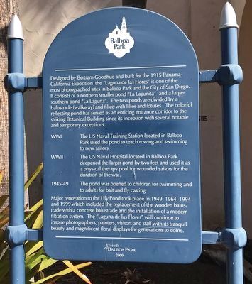
Laguna de Las Flores
WWI
The US Naval Training Station located in Balboa Park used the pond to teach rowing and swimming to new sailors.
WWII
The US Naval Hospital located in Balboa Park deepened the larger pond by two feet and used it as a physical therapy pool for wounded sailors for the duration of the war. The pond was opened to children for swimming and to adults for bait and fly casting.
Major renovation to the Lily Pond took place in 1949, 1964, 1994 and 1999 which included the replacement of the wooden balustrade with a concrete balustrade and the installation of a modern filtration system. The "Laguna de las Flores" will continue to inspire photographers, painters, visitors and staff with its tranquil beauty and magnificent floral displays for generations to come.
Erected 2009 by Friends of Balboa Park.
Topics. This historical marker is listed in these topic lists: Parks & Recreational Areas • War, World I • War, World II. A significant historical year for this entry is 1915.
Location. 32° 43.918′ N, 117° 8.944′ W. Marker is in San Diego, California, in San Diego County. Marker can be reached from El Prado near Old Globe Way. Touch for map. Marker is at or near this postal address: 1549 El Prado, San Diego CA 92101, United States of America. Touch for directions.
Other nearby markers. At least 8 other markers are within walking distance of this marker. The Botanical Building (within shouting distance of this marker); Casa del Prado (within shouting distance of this marker); Zoro Gardens Nudist Colony (about 400 feet away, measured in a direct line); House of Charm (about 600 feet away); The History of the Japanese Friendship Garden (about 700 feet away); California Quadrangle (approx. 0.2 miles away); Spreckels Organ and Pavilion (approx. 0.2 miles away); David Charles Collier (approx. 0.2 miles away). Touch for a list and map of all markers in San Diego.
Credits. This page was last revised on December 1, 2023. It was originally submitted on November 3, 2022, by Adam Margolis of Mission Viejo, California. This page has been viewed 95 times since then and 17 times this year. Photos: 1, 2. submitted on November 3, 2022, by Adam Margolis of Mission Viejo, California. • Bill Pfingsten was the editor who published this page.

