Near Hillsboro in Jefferson County, Missouri — The American Midwest (Upper Plains)
Covered Bridges in Missouri

Photographed by Jason Voigt, August 31, 2022
1. Covered Bridges in Missouri Marker
The ravages of time and progress took their toll on Missouri's covered bridge population. Fire, flood, abandonment or re-routing of once heavily used roadways and simple neglect left only eight covered bridges in the state in 1958; today only four are still standing.
Construction Materials
Elsewhere in this exhibit, you can find drawings of several of the most common truss designs used in covered bridge construction. Of the four covered bridges remaining in Missouri, three use the Howe-truss system, and one, Union Covered Bridge, employs the Burr-arch truss.
Just as there were several truss designs for the covered bridge builder to choose from, there were a variety of woods
this page online
Remaining Bridges - Common Woods
Union Covered Bridge, completed in 1871 by bridge builder Joseph Elliot, is the only Burr-arch truss still standing in Missouri. Located eight miles southwest of Paris in Monroe County, the bridge measures 120 feet long and is 17 feet, 6 inches wide.
Union Covered Bridge was built almost entirely of native oak. Oak is a common wood in northeast Missouri, easily available, hard, durable and reasonably easy to work with. All of the wood used in Union Covered Bridge, with the exception of the cedar shingles, is oak.
Another interesting feature of Union Covered Bridge is that the siding is horizontal, as it would be on a house; the other covered bridges in Missouri have vertical siding, as would be found on a barn.
Sandy Creek Covered Bridge is a Howe-truss bridge built originally in 1872 on the Hillsboro

Photographed by Jason Voigt, August 31, 2022
2. Covered Bridges in Missouri Marker
Marker is part of a kiosk with other markers
This former toll bridge was constructed of white pine. Although not a native to Missouri, this tree was, and still is, a common tree for lumber. The only native pine tree to Missouri is the shortleaf, or yellow pine found in the Ozarks. Today, however, white pines can be found growing in Missouri where they are used not only for lumber, but also for poles and posts.
Locust Creek Covered Bridge, built in 1868, was also known as Linn County Covered Bridge. It is located midway between Laclede and Meadville on what was once Route 8, the nation's first transcontinental highway. This bridge, built using a Howe-truss design, is the longest in the state at 151 feet.
Like Sandy Creek Covered Bridge, Locust Creek Covered Bridge is made largely of white pine. The truss system is pine: the siding, originally pine, has been replaced with cedar. As with all of the covered bridges in Missouri, the shingles on this bridge are cedar.
Burfordville Covered Bridge is
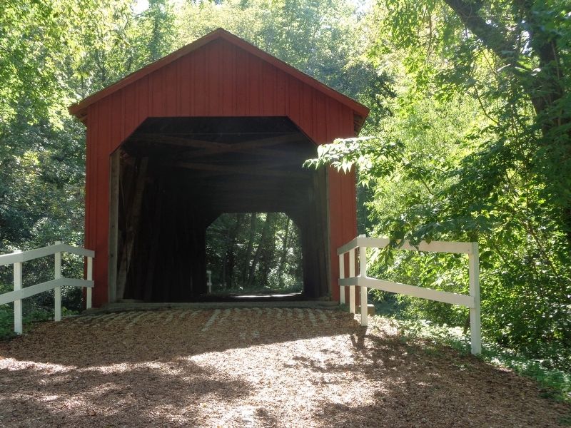
Photographed by Jason Voigt, August 31, 2022
3. Sandy Creek Covered Bridge
Located within shouting distance from the marker
This Howe-truss span is built mainly of yellow poplar, much of which was cut along the banks of the Whitewater River. In Missouri, yellow poplar is native only to the southeastern counties of the state. It makes excellent lumber, is easy to work, and naturally resistant to rot an insect damage. Today it is often used in such products as furniture, inferior finish, boxes, crates and veneer.
Erected by Missouri State Parks.
Topics and series. This historical marker is listed in this topic list: Bridges & Viaducts. In addition, it is included in the Covered Bridges series list. A significant historical month for this entry is May 1886.
Location. 38° 17.651′ N, 90° 31.562′ W. Marker is near Hillsboro, Missouri, in Jefferson County. It can be reached from Old Lemay Ferry Road. Marker is located at Sandy Creek Covered Bridge State Historic Site park. Touch for map.

Photographed by Jason Voigt, August 31, 2022
4. Missouri State Parks map
Next to the marker

Regionally, this marker is in the Missouri River Corridor and in Greater St. Louis. It is also in the American Midwest, in the Lewis & Clark Corridor, in the Corn Belt, and in the Great River Road Region. Globally, it is in North America, the Western Hemisphere, the Western World, and the Anglosphere. Historically, it finds itself in what was once the territory of the Mississippian Culture, the Louisiana Purchase, and the Antebellum South.
Other nearby markers. At least 8 other markers are within 5 miles of this marker, measured as the crow flies: History of Sandy Creek Covered Bridge (here, next to this marker); Restoration of Sandy Creek Covered Bridge (here, next to this marker); History of Covered Bridges in America (a few steps from this marker); Jefferson County (approx. 4.8 miles away); To Commemorate the Removal Of the County Seat From Herculaneum (approx. 4.8 miles away); Jefferson County Veterans Memorial (approx. 4.8 miles away); The Veterans of all Wars From Jefferson County (approx. 4.8 miles away); Governor Thomas C. Fletcher House (approx. 4.9 miles away). Touch for a list and map of all markers in Hillsboro.
Also see . . . Sandy Creek Covered Bridge State Historic Site. Missouri State Parks website entry (Submitted on November 29, 2022, by Jason Voigt of Glen Carbon, Illinois.)
Credits. This page was last revised on December 13, 2025. It was originally submitted on November 29, 2022, by Jason Voigt of Glen Carbon, Illinois. This page has been viewed 646 times since then and 102 times this year. Photos: 1, 2, 3, 4. submitted on November 29, 2022, by Jason Voigt of Glen Carbon, Illinois.
