Caspian in Iron County, Michigan — The American Midwest (Great Lakes)
Apple Blossom Trail
— Explore the History Behind the Beauty —
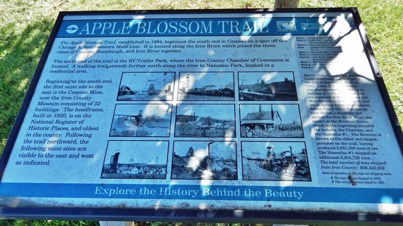
The Apple Blossom Trail, established in 1994, begins on the south end in Caspian on a spur off the Chicago & Northwestern Main Line. It is located along the Iron River, which joined the three cities of Caspian, Stambaugh, and Iron River together.
The north end of the trail is the RV/Trailer Park, where the Iron County Chamber of Commerce is located. A walking trail extends further north along the river to Nanaimo Park, located in a residential area.
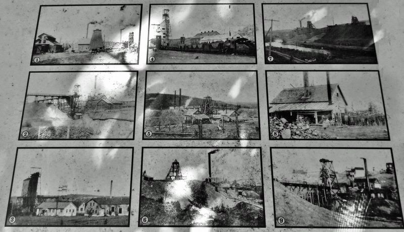
Beginning at the south end, the first mine site to the east is the Caspian Mine, now the Iron County Museum, consisting of 22 buildings. The headframe, built in 1920, is on the National Register of Historic Places, and oldest in the county. Following the trail northward, the following mine sites are visible to the east and west as indicated.
1 East • Caspian Mine (1901-1937)
2 East • Dober No. 1, Dober No. 2 and Duff (Earlier part of Riverton)
3 West • Hiawatha No. 2 (1935-1966)
East • Isabella Pit (Later part of Hiawatha No. 2)
4 West • Hiawatha No. 1 (1893-1951)
5 West • Chatham (1907-1920)
6 East • Iron River (AKA, Stambaugh and Riverton Group (1882-1931)
7 West • Wickwire (1911-1917)
8 West • Sheridan (1889-1900)
9 East • Delta (1920-1925)
Harvey Mellen, an early surveyor, found outcroppings of iron ore at the foot of Stambaugh Bluff in 1851. Later, D.C. MacKinnon, who accompanied W.H. Selden to the area in 1878, is credited with ore discovery at the Nanaimo and Sheridan mines in Iron River, and ore in Spring Valley, now Caspian. Selden found ore in Stambaugh near Mellen's discovery and opened the Iron River Mine, also known as the Riverton Group, which in the beginning included the Isabella, the Chatham, and the Hiawatha #1. The Riverton is known as the oldest and largest producer on the trail, having produced 5,881,550 tons of ore. The Hiawatha #1 shipped an additional 8,502,729 tons.
The total number of tons shipped from Iron County: 208,345,852.
Dates of operation on this sign are shipping dates.
☆ The last ore was shipped in 1978.
☆ The railroad service closed in 1981.
Erected by Iron County Heritage Trail.
Topics. This historical marker is listed in these topic lists: Industry & Commerce • Parks & Recreational Areas • Railroads & Streetcars • Settlements & Settlers. A significant historical year for this entry is 1851.
Location. 46° 4.029′ N, 88° 37.692′ W. Marker is in Caspian, Michigan, in Iron County. Marker is on Brady Avenue, 0.1 miles north of Caspian Avenue, on the left when traveling north. Marker is located just north of the Iron River, on the west side of the Apple Blossom Trail trailhead parking lot. Touch for map. Marker is at or near this postal address: 76 Brady Avenue, Caspian MI 49915, United States of America. Touch for directions.
Other nearby markers. At least 8 other markers are within walking distance of this marker. Caspian History (a few steps from this marker); The Cooling Pond (about 600 feet away, measured in a direct line); Snow Rollers 1900's (about 600 feet away); Powder House (about 600 feet away); Chicago & Northwestern Railway (about 600 feet away); The Big Splash (about 600 feet away); Narrow Gauge Underground Electric Train (about 700 feet away); Diamond Drill (about 700 feet away). Touch for a list and map of all markers in Caspian.
Also see . . .
1. Historical Overview of Iron County.
In 1851, Harvey Mellen came to this area which was populated by a small number of Indians, principally of the Menominee and Chippewa (Ojibway) tribes. Mellen reported an abundance of white pine in the vicinity and also noted sighting an outcrop of ore (“a ledge of red granite”) along the banks of the Iron River (then known as the Maple River). Excavation for this ore was delayed for 30 years, however, until the area became accessible by railroad and until economic conditions, with a growing demand for iron by American industries in the late nineteenth century, were more favorable(Submitted on January 3, 2023, by Cosmos Mariner of Cape Canaveral, Florida.)for development of mineral resources.Iron ore prospectors began to venture into the wilderness of the Iron County area in 1875. Early known explorers were John Armstrong along the Paint River on the east side of the county, and R.I., and William Selden with Donald C. MacKinnon along the Maple (Iron) River on the west side of the County. Both parties were successful in striking enough ore in 1880 to warrant opening mines; the Crystal Falls Mine on the east side and the Iron River (Riverton) Mine on the west side. The initial strikes brought a wave of prospectors to both river valleys, where additional mines were rapidly developed.
2. Apple Blossom Trail & Heritage Trail.
The paved trail (wheelchair accessible) starts across the road from the Iron County Museum in Caspian and weaves its way through areas of beautiful and historical Iron County. The bike path ends at Pentoga Park. It travels along the Iron River and near the site of the original railroad line that carried iron ore from the area. It travels through Caspian to Gaastra and along the original roadbed on 424 to Pentoga Park. The site of Harvey Mellen’s discovery of iron ore in 1851 is on the route. Among the scenic views are the abandoned mine quarry stocked with trout and a view of a small waterfall on the Iron River.(Submitted on January 3, 2023, by Cosmos Mariner of Cape Canaveral, Florida.)
Credits. This page was last revised on January 3, 2023. It was originally submitted on January 3, 2023, by Cosmos Mariner of Cape Canaveral, Florida. This page has been viewed 85 times since then and 22 times this year. Photos: 1, 2, 3. submitted on January 3, 2023, by Cosmos Mariner of Cape Canaveral, Florida.


