White Marsh in Baltimore County, Maryland — The American Northeast (Mid-Atlantic)
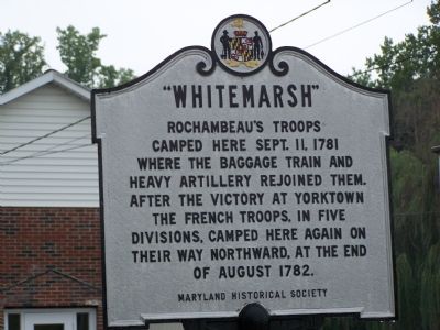
“Whitemarsh”
Erected 1964 by Maryland Historical Society.
Topics and series. This historical marker is listed in these topic lists: Military • War, US Revolutionary. In addition, it is included in the The Washington-Rochambeau Route series list. A significant historical month for this entry is September 1861.
Location. 39° 22.989′ N, 76° 25.737′ W. Marker is in White Marsh, Maryland, in Baltimore County. Marker is on Ebenezer Road, 0.2 miles west of Pulaski Highway (U.S. 40), on the right. Touch for map. Marker is in this post office area: White Marsh MD 21162, United States of America. Touch for directions.
Other nearby markers. At least 8 other markers are within 3 miles of this marker, measured as the crow flies. White Marsh War Memorial (about 400 feet away, measured in a direct line); Camp Chapel (approx. 1.6 miles away); Harry Dorsey Gough (approx. 1.6 miles away); Union of Brother and Sisters of Ford’s Asbury Lodge No. 1 (approx. 2.1 miles away); “Long Calm” (approx. 2.4 miles away); The Baltimore Embroidery / The Tanner Homestead (approx. 2.8 miles away); Germantown (approx. 2.8 miles away); Perry Hall (approx. 2.9 miles away). Touch for a list and map of all markers in White Marsh.
More about this marker. Marker is in front of the White Marsh Post Office and is parallel to the road.
This marker replaces an earlier one, erected by the state Roads Commission in 1938.
Credits. This page was last revised on June 16, 2016. It was originally submitted on August 19, 2007, by Bill Pfingsten of Bel Air, Maryland. This page has been viewed 2,756 times since then and 112 times this year. Last updated on August 21, 2007, by Bill Pfingsten of Bel Air, Maryland. Photo 1. submitted on August 19, 2007, by Bill Pfingsten of Bel Air, Maryland. • J. J. Prats was the editor who published this page.
