Highland Park in Saint Paul in Ramsey County, Minnesota — The American Midwest (Upper Plains)
Engineering the Mississippi / Ford Motor Company
Inscription.
New Dam Brings Access to Ocean to Minneapolis
Headline, Minneapolis Morning Tribune, July 4, 1917
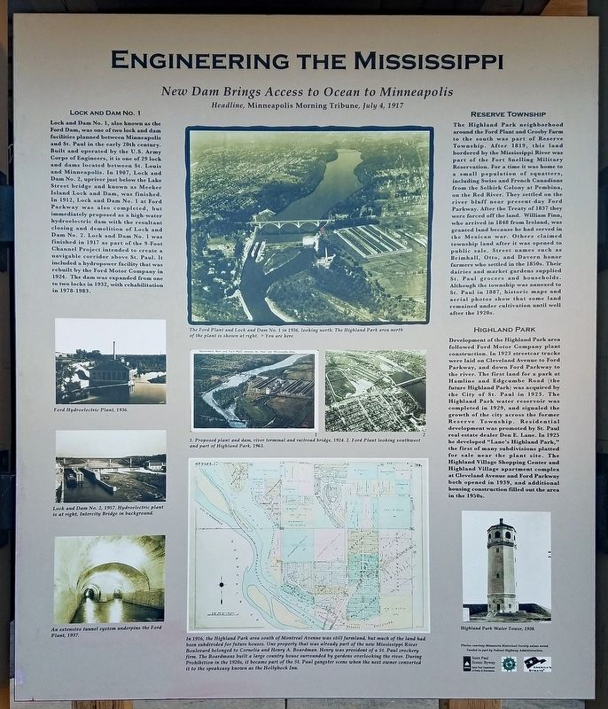
Lock and Dam No. 1
Lock and Dam No. 1, also known as the Ford Dam, was one of two lock and dam facilities planned between Minneapolis and St. Paul in the early 20th century. Built and operated by the U.S. Army Corps of Engineers, it is one of 29 lock and dams located between St. Louis and Minneapolis. In 1907, Lock and Dam No. 2, upriver just below the Lake Street bridge and known as Meeker Island Lock and Dam, was finished. In 1912, Lock and Dam No. 1 at Ford Parkway was also completed, but immediately proposed as a high-water hydroelectric dam with the resultant closing and demolition of Lock and Dam No. 2. Lock and Dam No. 1 was finished in 1917 as part of the 9-Foot Channel Project intended to create a navigable corridor above St. Paul. It included a hydropower facility that was rebuilt by the Ford Motor Company in 1924. The dam was expanded from one to two locks in 1932, with rehabilitation in 1978–1983.
Ford Hydroelectric Plant, 1936.
Lock and Dam No. 2, 1957. Hydroelectric plant is at right, Intercity Bridge in background.
An extensive tunnel system underpins the Ford Plant, 1937.
The Ford Plant and Lock and Dam No. 1 in 1936, looking north. The Highland Park area north of the plant is shown at right.
Proposed plant and dam, river terminal and railroad bridge, 1924.
Ford Plant looking southwest and part of Highland Park, 1963.
In 1916, the Highland Park area south of Montreal Avenue was still farmland, but much of the land had been subdivided for future houses. One property that was already part of the new Mississippi River Boulevard belonged to Cornelia and Henry A. Boardman. Henry was president of a St. Paul crockery firm. The Boardmans built a large country house surrounded by gardens overlooking the river. During Prohibition in the 1920s, it became part of the St. Paul gangster scene when the next owner converted it to the speakeasy known as the Hollyhock Inn.
The Highland Park neighborhood around the Ford Plant and Crosby Farm to the south was part of Reserve Township. After 1819, this land bordered by the Mississippi River was part of the Fort Snelling Military Reservation. For a time it was home to a small population of squatters, including Swiss and French Canadians from the Selkirk Colony at Pembina, on the Red River. They settled on the river bluff near present-day Ford Parkway. After the Treaty of 1837 they were forced off the land. William Finn, who arrived in 1848 from Ireland, was granted land
because he had served in the Mexican war. Others claimed township land after it was opened to public sale. Street names such as Brimhall, Otto, and Davern honor farmers who settled in the 1850s. Their dairies and market gardens supplied St. Paul grocers and households. Although the township was annexed to St. Paul in 1887, historic maps and aerial photos show that some land remained under cultivation until well after the 1920s.
Highland Park
Development of the Highland Park area followed Ford Motor Company plant construction. In 1923 streetcar tracks were laid on Cleveland Avenue to Ford Parkway, and down Ford Parkway to the river. The first land for a park at Hamline and Edgcumbe Road (the future Highland Park) was acquired by the City of St. Paul in 1923. The Highland Park water reservoir was completed in 1929, and signaled the growth of the city across the former Reserve Township. Residential development was promoted by St. Paul real estate dealer Den E. Lane. In 1925 he developed "Lane's Highland Park," the first of many subdivisions platted for sale near the plant site. The Highland Village Shopping Center and Highland Village apartment complex at Cleveland Avenue and Ford Parkway both opened in 1939, and additional housing construction filled out the area in the 1950s.
Highland Park Water Tower, 1930.
Ford
Motor Company
Twin Cities Assembly Plant
The new plant ... is part of a campaign to show the American people what can be done by the use of water power now being permitted to go to waste ...
New York Times, June 9, 1923
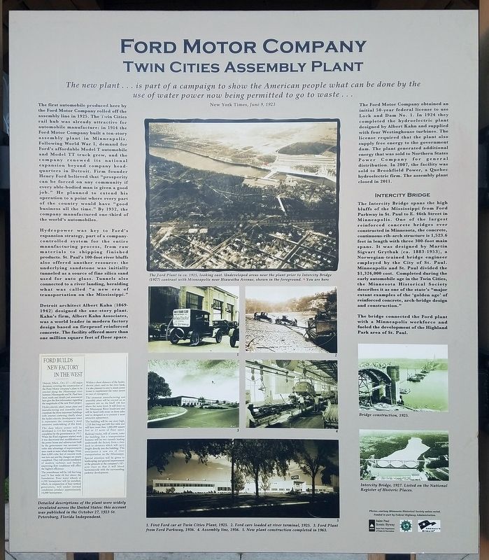
The first automobile produced here by the Ford Motor Company rolled off the assembly line in 1925. The Twin Cities rail hub was already attractive for automobile manufacture: in 1914 the Ford Motor Company built a ten-story assembly plant in Minneapolis. Following World War I, demand for Ford's affordable Model T automobile and Model TT truck grew, and the company renewed its national expansion beyond company headquarters in Detroit. Firm founder Henry Ford believed that "prosperity can be forced on any community if every able-bodied man is given a good job." He planned to extend his operation to a point where every part of the country would have "good business all the time." By 1932, the company manufactured one-third of the world's automobiles.
Hydropower was key to Ford's expansion strategy, part of a company-controlled system for the entire manufacturing process, from raw materials to shipping finished products. St. Paul's 100-foot river bluffs also offered another resource: the underlying sandstone was initially tunneled as a source of fine silica sand used for auto glass. Tunnels also connected to a river landing, heralding what was called "a new era of transportation on the Mississippi."
Detroit architect Albert Kahn (1869-1942) designed the one-story plant. Kahn's firm, Albert Kahn Associates, was a world leader in modern factory design based on fireproof reinforced concrete. The facility offered more that one million square feet of floor space.
Detailed descriptions of the plant were widely circulated across the United States: this account was published in the October 27, 1923 St. Petersburg, Florida Independent.
The Ford Plant in ca. 1925, looking east. Undeveloped areas near the plant prior to Intercity Bridge (1927) contrast with Minneapolis near Hiawatha Avenue, shown in the foreground.
1. First Ford car at Twin Cities Plant, 1925. 2. Ford cars loaded at river terminal, 1925. 3. Ford Plant from Ford Parkway, 1936. 4. Assembly line, 1956. 5. New plant construction completed in 1963.
The Ford Motor Company obtained an initial 50-year federal license to use Lock and Dam No. 1. In 1924 they completed the hydroelectric plant designed by Albert Kahn and supplied with four Westinghouse turbines. The license required that the plant also supply free energy to the government dam. The plant generated additional energy that was sold to Northern States Power Company for general distribution. In 2007, the facility was sold to Brookfield Power, a Quebec hydroelectric firm. The assembly plant closed in 2011.
Intercity Bridge
The Intercity Bridge spans the high bluffs of the Mississippi from Ford Parkway in St. Paul to E. 46th Street in Minneapolis. One of the largest reinforced concrete bridges ever constructed in Minnesota, the concrete, continuous-rib-arch structure in 1,523.6 feet in length with three 300-foot main spans. It was designed by Martin Sigvart Grytbak (ca. 1993–1953), a Norwegian-trained bridge engineer employed by the City of St. Paul. Minneapolis and St. Paul divided the $1,324,000 cost. Completed during the early automobile age in the Twin Cities, the Minnesota Historical Society described it as one of the state's "major extant examples of the 'golden age' of reinforced concrete, arch-bridge design and construction."
The bridge connected the Ford plant with a Minneapolis workforce and fueled the development of the Highland Park area of St. Paul.
Bridge construction, 1925.
Intercity Bridge, 1927. Listed on the National Register of Historic Places.
Erected by Saint Paul Department of Parks & Recreation.
Topics. This historical marker is listed in these topic lists: Bridges & Viaducts • Industry & Commerce • Settlements & Settlers • Waterways & Vessels. A significant historical year for this entry is 1912.
Location. 44° 54.848′ N, 93° 11.878′ W. Marker is in Saint Paul, Minnesota, in Ramsey County. It is in Highland Park. Marker is on Mississippi River Boulevard north of Village Way, on the left when traveling north. Marker is at the south end of the Ford Dam Scenic Overlook. Touch for map. Marker is at or near this postal address: 965 Mississippi River Boulevard S, Saint Paul MN 55116, United States of America. Touch for directions.
Other nearby markers. At least 8 other markers are within walking distance of this marker. Hydro Electric Turbine (within shouting distance of this marker); Wing Dams (approx. 0.2 miles away); The Lock and Dam No. 1 Story (approx. ¼ mile away); Big Water / Stairway of Water (approx. ¼ mile away); Minneapolis Locks and Dams (approx. half a mile away); 3 – Master Map (approx. half a mile away); 1–Main Entrance Minnehaha Lower Glen (approx. half a mile away); Geology of Minnesota (approx. 0.6 miles away).
Credits. This page was last revised on February 12, 2023. It was originally submitted on January 7, 2023, by McGhiever of Minneapolis, Minnesota. This page has been viewed 220 times since then and 65 times this year. Photos: 1, 2, 3. submitted on January 7, 2023, by McGhiever of Minneapolis, Minnesota. • J. Makali Bruton was the editor who published this page.


