Pittsburg Landing near Shiloh in Hardin County, Tennessee — The American South (East South Central)
Army of the Tennessee
Major General U.S. Grant
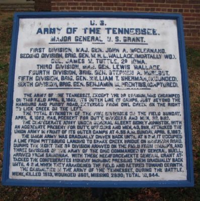
Army of the Tennessee.
Major General U.S. Grant.
First Division, Maj. Gen. John A. McClernand.
Second Division, Brig. Gen. W.H.L. Wallace (mortally wd.),
Col. James M. Tuttle, 2d Iowa.
Third Division, Maj. Gen. Lewis Wallace.
Fourth Division, Brig. Gen. Stephen A. Hurlbut.
Fifth Division, Brig. Gen. William T. Sherman, (wounded).
Sixth Division, Brig. Gen. Benjamin M. Prentiss, (captured).
The Army of the Tennessee, except the 3d Division was encamped on this field April 6, 1862. Its outer line of camps, just beyond the Hamburg and Purdy Road, extended from Owl Creek on the right to Lick Creek on the left.
The total strength of the five divisions on the field Sunday, April 6, 1862, was present for duty, officer and men, 39,830.
The Confederate army under General Albert Sidney Johnston, with an aggregate present for duty, officers and men, 43,968, attacked the Union army in front of its outer camps at 4.55 a.m. Sunday, April 6, 1862.
The Union army was gradually driven back until at 6 p.m. it occupied a line from Pittsburg Landing to Snake Creek Bridge on Savannah Road. During the night the 3d Division arrived on the field from Crump's, and three divisions of the Army of the Ohio commanded by General Buell arrived from Savannah. With these reenforcements General Grant attacked the Confederates Monday morning pressing them gradually back until 4 p.m. when they abandoned the field and retired toward Corinth.
The casualties in the Army of the Tennessee, during the battle, were killed 1513, wounded 6601, missing 2830; Total 10,944.
Erected by Shiloh National Military Park Commission. (Marker Number A 1.)
Topics and series. This historical marker is listed in this topic list: War, US Civil. In addition, it is included in the Former U.S. Presidents: #18 Ulysses S. Grant series list. A significant historical date for this entry is April 6, 1931.
Location. 35° 9.073′ N, 88° 19.329′ W. Marker is near Shiloh, Tennessee, in Hardin County. It is in Pittsburg Landing. Marker is on Pittsburg Landing Road, on the right when traveling west. Located next to the visitor center at Shiloh National Military Park. Touch for map. Marker is in this post office area: Shiloh TN 38376, United States of America. Touch for directions.
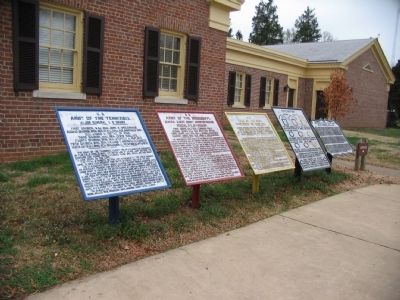
Other nearby markers. At least 8 other markers are within walking distance of this marker. Army of the Mississippi (here, next to this marker); Army of the Ohio (here, next to this marker); Forest, Farms, and Creeks (within shouting distance of this marker); Battlefield Preserved (within shouting distance of this marker); 55th Illinois Infantry (about 300 feet away, measured in a direct line); Battery H, 1st Illinois Light Artillery (about 300 feet away); Illinois Cavalry (about 300 feet away); Fourth Division (about 400 feet away). Touch for a list and map of all markers in Shiloh.
More about this marker. This is one of three duplicated tablets in the park outlining the actions of the Army of the Tennessee.
Also see . . . Battle of Shiloh. Wikipedia entry (Submitted on February 15, 2022, by Larry Gertner of New York, New York.)

Photographed By Craig Swain, March 16, 2009
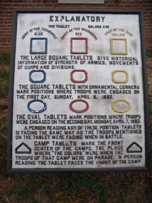
3. Explaination of the Tablet System at Shiloh
Shiloh features a rather complex set of tablets to interpret the movements of the armies. Each army uses a different color scheme - blue for the Army of the Tennessee, yellow for the Army of the Ohio, and red for the Confederate Army of the Mississippi. The different shapes of the tablets indicate which day the action described took place. "House" shaped tablets indicate camp sites.

Photographed By Craig Swain
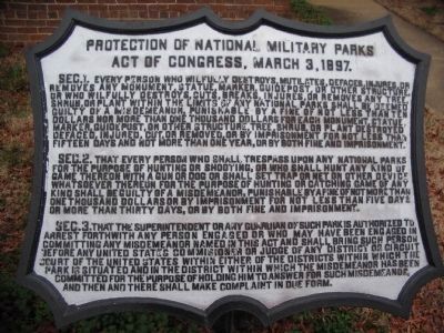
4. Protection of the National Military Parks
A tablet on the end of the cluster provides the full text of an Act passed by Congress on March 3, 1897 which provided for protection of the military parks. The five original parks were Chickamauga-Chattanooga, Shiloh, Gettysburg, Antietam, and Vicksburg.
Credits. This page was last revised on February 7, 2023. It was originally submitted on August 4, 2009, by Craig Swain of Leesburg, Virginia. This page has been viewed 805 times since then and 9 times this year. Photos: 1, 2, 3. submitted on August 4, 2009, by Craig Swain of Leesburg, Virginia. 4. submitted on August 5, 2009, by Craig Swain of Leesburg, Virginia.

