Havre de Grace in Harford County, Maryland — The American Northeast (Mid-Atlantic)
Lapidum - "A Place of Stones"
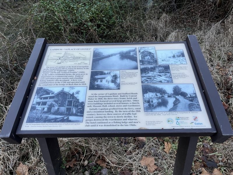
At the corner of Lapidum and Stafford Roads stood the Susquehanna Hotel. Built by Conrad Baker in 1868, the three-story frame, brick and stone hotel featured several large porches. Other town buildings included several houses, a church, mill, Masonic Hall, school, stores and warehouses. Initially Lapidum profited from the ferry, canal and a steamboat landing. By the turn-of-the-20th -century, however, these sources of traffic had ceased, causing the town to slowly decline. Ice gorges destroyed the warehouses and wharves. The hotel continued as a fishing lodge and men' club until it was demolished in the late 1960s.
Erected by Maryland State Parks.
Topics. This historical marker is listed in these topic lists: Bridges & Viaducts • Industry & Commerce • Settlements & Settlers • Waterways & Vessels. A significant historical year for this entry is 1818.
Location. 39° 35.912′ N, 76° 7.772′ W. Marker is in Havre de Grace, Maryland, in Harford County. Marker is on Stafford Road, on the right when traveling south. Touch for map. Marker is at or near this postal address: 401 Lapidum Rd, Havre de Grace MD 21078, United States of America. Touch for directions.
Other nearby markers. At least 8 other markers are within walking distance of this marker. Canal Lock #9 (a few steps from this marker); Susquehanna State Park (about 300 feet away, measured in a direct line); Susquehanna Hotel (about 300 feet away); River Crossing (about 500 feet away); Jacob Tome, Town Father (approx. 0.9 miles away); On Alert (approx. 0.9 miles away); John A. J. Creswell (approx. 0.9 miles away); Snow's Battery (approx. 0.9 miles away). Touch for a list and map of all markers in Havre de Grace.
Credits. This page was last revised on January 18, 2023. It was originally submitted on January 13, 2023, by Adam Margolis of Mission Viejo, California. This page has been viewed 184 times since then and 58 times this year. Photos: 1, 2. submitted on January 13, 2023, by Adam Margolis of Mission Viejo, California. • Bill Pfingsten was the editor who published this page.

