Groningen, Netherlands — Northwestern Europe
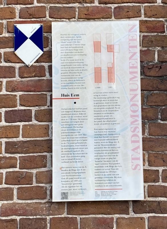
Huis Eem
— Stadsmonumenten —
Hoewel de voorgevel anders doet vermoeden, ligt de oorsprong van het pand ‘Eem’ rond 1330. Het aanvankelijk 17 meter lange huis had als hoofdvertrek een 4,50 meter hoge zaal, met daaronder een kelder en daarboven een verdieping en een zolder. In de 17e eeuw werd in de zaal een tussenverdieping aangebracht voor extra opslag en werd de ruimte in tweeën en later zelfs in drieën gesplitst. Doordat bij de restauratie een van de tussenwanden niet terugkeerde, zitten de bewoners er nu warmpjes bij met een middeleeuwse en een 18e eeuwse haard in één vertrek.
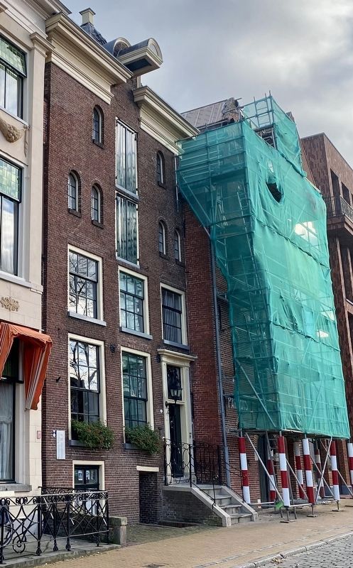
Oorspronkelijk had het pand een topgevel. Blijkens twee zandstenen neuten, links en rechts van de voordeur, werd deze in 1730 naar 18e eeuwse inzichten vervangen door een klokgevel met grote schuiframen. De huidige zware kroonlijst en de pakhuisraampjes zijn overigens pas van 1839. Het vanaf de straat niet zichtbare achterhuis werd op z’n laatst in de 17e eeuw gebouwd als bedrijfsruimte, maar werd in de daaropvolgende eeuw aan de oostkant ingekort. Zo ontstond de ‘keucken met de hoff’. Een overdekte gang, van in totaal 40 meter, verbindt nu beide delen.
Het zuivere water van de A maakte de Hoge der A tot een ideale vestigingsplaats voor bierbrouwerijen. Ook dit pand wordt in een koopakte uit 1695 een ‘brouwerije’ genoemd. Als de eigenaar het na zestien jaar weer verkoopt, is hiervan echter niets meer terug te vinden. De toenmalige gebruiker zag kennelijk meer in zeep dan in gerstenat, want er wordt dan gesproken van een kleine en een grote zeepketel. Na de brouwers en de zeepzieders kwamen er zeilmakers, zaadtelers, graan- en aardappelhandelaren in het pand, dat altijd zowel woon- als pakhuis is geweest.
Een aantal eigenaren en hun buren was ‘mennist’ (doopsgezind). Aangezien zij door hun handel en wandel niet bepaald onbemiddeld waren, werd de Hoge der A wel de ‘Mennistenhemel’ genoemd. Met de aanleg van nieuwe kanalen en havens verplaatste de graanhandel zich vanaf het eind van de vorige eeuw en ging het ‘hemelse’ karakter van de buurt verloren. Veel panden, waaronder ook Hoge der A 6, raakten in verval. Voor dit pand kwam na 1974 het herstel in de vorm van een grondige restauratie. Bij deze verbouwing richtten de bewoners een deel van het voorhuis in als concertruimte.
While the front suggests otherwise, the origin of House “Eem” is from 1330. The original 17-meter-long house had as the main room a 4.50-meter-high room, with beneath it a basement
and above a second floor plus addict. In the 17th century, another floor was built within the main room for extra storage. This floor was divided into two, and later three parts. Because at the restoration one of the intermediate walls was not included, the residents now have a medieval and 18th-century fireplace in one room.
Originally the building had a top gable, supposedly two sandstone seating blocks left and right of the front door. In 1730 these were replaced according to 18th-century perspective by a clock gable with big sliding windows. However, the current heavy crown cornice and warehouse windows date from 1839. The back house which is not visible from the street was constructed at the latest in the 17th century as an office building but was shortened at the east-side in the next century. This is the reason the “keucken met de hoff” (kitchen with courtyard) came to exist. Currently, both parts are connected by a 40 meters long roofed hallway.
The clean water of the A made the “Hoge der A” a great street for beer breweries. This building was also named a brewery in the purchase deed from 1695. However, when the owner sells it again after sixteen years, there was no indication of this at all. The former owner apparently saw more luck in soap than barley beer. Because then you speak of a small and big soap cauldron. After the brewers and soap makers came the sailmakers, seed growers, wheat and potato traders. This building has always been both a residential house and a warehouse at the same time.
A couple of owners and their neighbors were “mennist” (Baptist). Because of the fact that their trades and doings were not without means, the Hoge der A was also called the “mennist heaven”. With the construction of new roads and canals the wheat trade moved elsewhere and from the end of the previous century, this heavenly character of the area was lost. A lot of buildings including Hoge der A 6 fell into disrepair. This house was restored in 1974. When rebuilding, the residents designed a part of the front house as a concert space.
Erected by Gemeente Groningen. (Marker Number 29.)
Topics and series. This historical marker is listed in these topic lists: Architecture • Industry & Commerce. In addition, it is included in the Groningen Stadsmonumenten series list. A significant historical year for this entry is 1330.
Location. 53° 13.024′ N, 6° 33.584′ E. Marker is in Groningen. Marker is on Hoge der A, on the right when traveling north. Touch for map. Marker is at or near this postal address: Hoge der A 6, Groningen 9718 BN, Netherlands. Touch for directions.
Other nearby markers. At least 8 other markers are within walking distance of this marker. H.W. Mesdag and N.E.M. Pareau (a few steps from this marker); Hoge der A 9 (a few steps from this marker); Alida (about 90 meters away, measured in a direct line); A-Kerk / A-Church (about 150 meters away); Postkantoor/ Post Office (about 180 meters away); Evert Jan Thomassen à Thuessink (about 180 meters away); Korenbeurs / Grain Exchange (approx. 0.3 kilometers away); Oprichting van de Loge / Establishment of I.O.O.F. Lodge (approx. 0.3 kilometers away). Touch for a list and map of all markers in Groningen.
Credits. This page was last revised on December 31, 2023. It was originally submitted on January 18, 2023, by Andrew Ruppenstein of Lamorinda, California. This page has been viewed 65 times since then and 12 times this year. Photos: 1, 2. submitted on January 18, 2023, by Andrew Ruppenstein of Lamorinda, California.

